
Sandwich is a town and civil parish in the Dover District of Kent, south-east England. It lies on the River Stour and has a population of 4,985. Sandwich was one of the Cinque Ports and still has many original medieval buildings, including several listed public houses and gates in the old town walls, churches, almshouses and the White Mill. While once a major port, it is now 2 miles (3 km) from the sea due to the disappearance of the Wantsum Channel. Its historic centre has been preserved. Sandwich Bay is home to nature reserves and two world-class golf courses, Royal St George's and Prince's. The town is also home to many educational and cultural events. Sandwich also gave its name to the food by way of John Montagu, 4th Earl of Sandwich, and the word sandwich is now found in several languages.

Kilpeck is a village and civil parish in the county of Herefordshire, England. It is about nine miles (14 km) southwest of Hereford, just south of the A465 road and Welsh Marches Line to Abergavenny, and about five miles (8 km) from the border with Wales. On 1 April 2019 the parishes of Kenderchurch, St Devereux, Treville and Wormbridge were merged with Kilpeck.
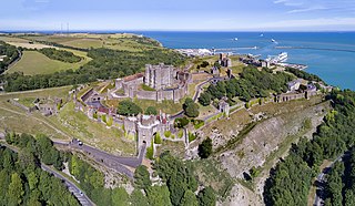
Dover Castle is a medieval castle in Dover, Kent, England and is Grade I listed. It was founded in the 11th century and has been described as the "Key to England" due to its defensive significance throughout history. Some writers say it is the largest castle in England, a title also claimed by Windsor Castle.
Gamlingay is a village and civil parish in the South Cambridgeshire district of Cambridgeshire, England about 14 miles (23 km) west southwest of Cambridge.
Okehampton is a town and civil parish in West Devon in the English county of Devon. It is situated at the northern edge of Dartmoor, and had a population of 5,922 at the 2011 census. Two electoral wards are based in the town. Their joint population at the same census was 7,500.

Fordwich is a market town and a civil parish in east Kent, England, on the River Stour, northeast of Canterbury.

Oxford Castle is a large, partly ruined medieval castle on the western side of central Oxford in Oxfordshire, England. Most of the original moated, wooden motte and bailey castle was replaced in stone in the late 12th or early 13th century and the castle played an important role in the conflict of the Anarchy. In the 14th century the military value of the castle diminished and the site became used primarily for county administration and as a prison. The surviving rectangular St George's Tower is now believed to pre-date the remainder of the castle and be a watch tower associated with the original Saxon west gate of the city.

Buckland Monachorum is a village and civil parish in the West Devon district of Devon, England, situated on the River Tavy, about 10 miles north of Plymouth.

The Priory of St. Mary the Virgin and St. Martin of the New Work, or Newark, commonly called Dover Priory, was a priory at Dover in southeast England. It was variously independent in rule, then occupied by canons regular of the Augustinian rule, then finally monks of the Benedictine rule as a cell of Christchurch Monastery, Canterbury.

Colchester in Essex, England, has a number of notable churches.

Fulbrook is a village and civil parish immediately northeast of Burford in West Oxfordshire. The 2011 Census recorded the parish's population as 437.

Puttenham is a village in Surrey, England, located just south of the Hog's Back which is the narrowest stretch of the North Downs. Puttenham is about midway between the towns of Guildford and Farnham, and can be accessed from the A31 trunk road which runs along the spine of the Hog's Back. Villages nearby include Wanborough, Shackleford and Compton.

Drayton St. Leonard is a village and civil parish on the River Thame in Oxfordshire, about 8 miles (13 km) southeast of Oxford.

Honington is an English village and civil parish in the South Kesteven district of Lincolnshire. It lies just north of the junction between the A153 and A607 roads, about 5.5 miles (8.9 km) north of Grantham and 8 miles (12.9 km) west of Sleaford.
The History of Dover, because of the town's proximity to the Continent begins when Stone Age people crossed what was then a land bridge, before the opening up of the English Channel. Since then, successive invasions of peoples have taken place. Archaeological finds have revealed a great deal, particularly about cross channel trade and the attempts of those various inhabitants to build large-scale defences against European invaders on this part of the English coast.

Whatcote is a village and civil parish in Warwickshire, England, about 4 miles (6.4 km) northeast of Shipston on Stour in the Vale of the Red Horse. The population at the 2011 census was 143.

St John the Baptist's Church is a redundant Anglican church in the centre of the town of Stamford, Lincolnshire, England. It is recorded in the National Heritage List for England as a designated Grade I listed building, and is under the care of the Churches Conservation Trust.
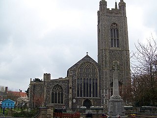
St Mary's Church is a redundant Anglican church in the town of Bungay, Suffolk, England. The church and the ruins of the adjacent priory are recorded in the National Heritage List for England as a designated Grade I listed building, and are under the care of the Churches Conservation Trust. The church stands in the centre of the town on St Mary's Street, the A144 road.

The Church of St Mary the Virgin is a Grade II* listed Anglican church, a parish church in Dover, Kent, and is situated on Cannon Street in the town centre. There was a church on this site in Saxon times. It was largely rebuilt in the 19th century.

Holy Trinity Church in Eccleshall, Staffordshire, England, is a Grade I listed Anglican church.


