
The London Borough of Barnet is a local authority area on the northern outskirts of London. The borough was formed in 1965 from parts of the ceremonial counties of Middlesex and Hertfordshire. It is the second largest London borough by population with 389,344 inhabitants as of 2021, also making it the 17th largest district in England. The borough covers an area of 86.74 square kilometres (33 sq mi), the fourth highest of the 32 London boroughs, and has a population density of 45.8 people per hectare, which ranks it 25th.

Whetstone is a suburb of north London, in the London Borough of Barnet, bearing the postcode N20. It is served by an Underground station called Totteridge and Whetstone. Whetstone is around 7.8 miles North of Charing Cross and is a settlement in the London Borough of Barnet, previously part of the Borough of Finchley prior to the 1960s. The combined areas of Totteridge and Whetstone was, at the outset of the 21st century, found to be the 63rd-richest of the more than 9,000 wards of the United Kingdom.

Chipping Barnet or High Barnet is a suburban market town in north London, forming part of the London Borough of Barnet, England. It is a suburban development built around a 12th-century settlement, and is located 10+1⁄2 miles (17 km) north-northwest of Charing Cross, 3 miles (4.8 km) east from Borehamwood, 5.2 miles (8.4 km) west from Enfield and 3.2 miles (5.1 km) south from Potters Bar. Its population, including its localities East Barnet, New Barnet, Hadley Wood, Monken Hadley, Cockfosters and Arkley, was 47,359 in 2011.

New Southgate is a residential suburb straddling three Outer London Boroughs: a small part of the east of Barnet, a south-west corner of Enfield and in loosest definitions, based on nearest railway stations, a small northern corner of Haringey in North London, England where estates merge into Bounds Green.

Friern Barnet is a suburban area within the London Borough of Barnet, 7.4 miles (11.9 km) north of Charing Cross. Its centre is formed by the busy intersection of Colney Hatch Lane, Woodhouse Road and Friern Barnet Road.
Friern Barnet Urban District was a local government area in Middlesex, England created in 1883 from the civil parish Friern Barnet. It was succeeded by the London Borough of Barnet in 1965 as one of the smaller of its contributory predecessor districts. It was at the local level governed for 11 years by a local board, then by Friern Barnet Urban District Council which operated primarily with separate functions from the County Council, operating occasionally for major planning decisions and major projects together with that body, Middlesex County Council.

Ossulstone is an obsolete subdivision (hundred) covering 26.4% of – and the most metropolitan part – of the historic county of Middlesex, England. It surrounded but did not include the City of London and the area has been entirely absorbed by the growth of London. It now corresponds to the seven London Boroughs of Inner London north of the Thames and, from Outer London, in decreasing order, certain historic parishes of the London boroughs of Ealing, Brent, Barnet, and Haringey.
The Finsbury Division was one of four divisions of the Hundred of Ossulstone, in the historic county of Middlesex, England. The area of the Finsbury Division is now the core of modern north London. The other divisions were named Holborn, Kensington and Tower. Ossulstone hundred was divided in the seventeenth century, with each of the four divisions replacing the hundred for most administrative purposes.

St Peter le Poer was a parish church on the west side of Broad Street in the City of London. Established before the end of the 12th Century, it was rebuilt in 1540, and again in 1792 to a design by Jesse Gibson with a circular nave. It was demolished in 1907.

St John the Evangelist Friday Street was a church in Bread Street Ward of the City of London. It was destroyed in the Great Fire of London of 1666, and not rebuilt, the parish being united with that of All Hallows, Bread Street.

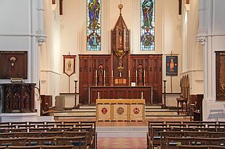
St John the Evangelist is an Anglican church on Friern Barnet Road in north London. It is a late example of the Gothic Revival Style by Victorian architect John Loughborough Pearson, begun in 1890-91 and completed after his death by his son Frank Loughborough Pearson.
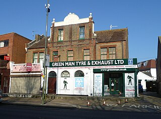
The Green Man was a public house at 1308 High Road, Whetstone, north London, that dated from the 15th century and subsequently redeveloped several times. It closed in the late 20th century and is now a motor repair business.

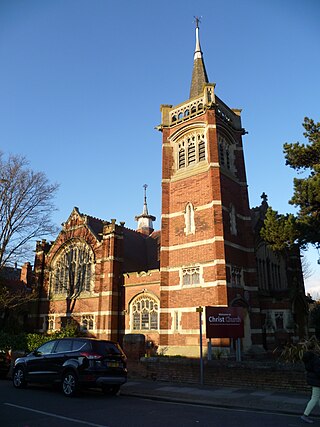
Christ Church Barnet, is a Church of England church in St Albans Road, Chipping Barnet.
The Parish Church of Saint Paul is a Church of England parish church in New Southgate, London Borough of Enfield, London. St Paul's is an inclusive, welcoming church with an all-age community. Service details are available on the church's website: https://stpaulsnewsouthgate.co.uk/. Baptisms, Weddings and Funerals are regularly taken at St Paul's.
Christ Church New Southgate & Friern Barnet is a Baptist United Reform church in Friern Barnet, London. The building is grade II listed with Historic England.

All Saints' Church is a Church of England church in Oakleigh Road North, Oakleigh Park, London. The church is sometimes referred to as All Saints' Friern Barnet. It is a grade II listed building.

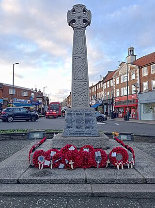
The New Barnet War Memorial stands on a triangular plot at the junction of Station Road and Lyonsdown Road, New Barnet. It is grade II listed with Historic England.
East Barnet War Memorial is a memorial to the dead of the First and Second World Wars from East Barnet, London. It was unveiled on 27 June 1920 and originally stood on the crossroads of East Barnet Road and Church Hill Road, but was later moved a short distance so that it now stands in front of the Brookside Methodist Church.

Friern Barnet Parishioners War Memorial is located in the churchyard of St James the Great, Friern Barnet Lane, London. It commemorates those of the parish who died on active service during the First World War.

St Peter's Church, is an early Victorian Church of England church in Arkley, in the London Borough of Barnet. It is a grade II listed building.
