
Chelsea is a neighborhood on the West Side of the borough of Manhattan in New York City. The area's boundaries are roughly 14th Street to the south, the Hudson River and West Street to the west, and Sixth Avenue to the east, with its northern boundary variously described as near the upper 20s or 34th Street, the next major crosstown street to the north. To the northwest of Chelsea is the neighborhood of Hell's Kitchen, as well as Hudson Yards; to the northeast are the Garment District and the remainder of Midtown South; to the east are NoMad and the Flatiron District; to the southwest is the Meatpacking District; and to the south and southeast are the West Village and the remainder of Greenwich Village. Chelsea is named after the Royal Hospital Chelsea in London, England.
North River is an alternative name for the southernmost portion of the Hudson River in the vicinity of New York City and northeastern New Jersey in the United States.
Henry Morrison Flagler was an American industrialist and a founder of Standard Oil, which was first based in Ohio. He was also a key figure in the development of the Atlantic coast of Florida and founder of the Florida East Coast Railway. He is also known as a founder of the cities of Miami and Palm Beach, Florida.

The Florida East Coast Railway is a Class II railroad operating in the U.S. state of Florida, currently owned by Grupo México.

For the purposes of this article, the Jersey City area extends North to Edgewater, South to Bayonne and includes Kearny Junction and Harrison but not Newark. Many routes east of Newark are listed here.

Prime F. Osborn III Convention Center is a 265,000-square-foot (24,600 m2) convention center located in downtown Jacksonville, Florida. Opened in 1986, it was built incorporating Jacksonville Terminal Complex / Union Station as well as several thousand square feet of newly built structure.

The Journal Square Transportation Center is a multi-modal transportation hub located on Magnolia Avenue and Kennedy Boulevard at Journal Square in Jersey City, New Jersey, United States. Owned and operated by the Port Authority of New York and New Jersey, the complex includes a ten-story tower, a retail plaza, a bus terminal, a two-level parking facility, and the Journal Square station of the PATH rail transit system. The underground station has a high ceiling and a mezzanine level connecting the platforms.

The Meatpacking District is a neighborhood in the New York City borough of Manhattan that runs from West 14th Street south to Gansevoort Street, and from the Hudson River east to Hudson Street. The Meatpacking Business Improvement District along with signage in the area, extend these borders farther north to West 17th Street, east to Eighth Avenue, and south to Horatio Street.


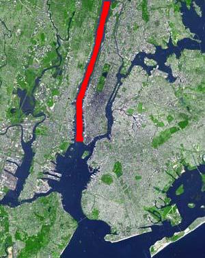
The West Side Line, also called the West Side Freight Line, is a railroad line on the west side of the New York City borough of Manhattan. North of Penn Station, from 34th Street, the line is used by Amtrak passenger service heading north via Albany to Toronto; Montreal; Niagara Falls and Buffalo, New York; Burlington, Vermont; and Chicago. South of Penn Station, a 1.45-mile (2.33 km) elevated section of the line, abandoned since 1980, has been transformed into an elevated park called the High Line. The south section of the park from Gansevoort Street to 20th Street opened in 2009 and the second section up to 30th Street opened in 2011, while the final section to 34th Street opened in 2014.
The New York and Putnam Railroad, nicknamed the Old Put, was a railroad line that operated between the Bronx and Brewster in New York State. It was in close proximity to the Hudson River Railroad and New York and Harlem Railroad. All three came under ownership of the New York Central system in 1894. The railroad was abandoned starting in 1958, and most of the former roadbed has been converted to rail trail use.

Getty Square is the name for downtown Yonkers, New York, centered on the public square. Getty Square is the civic center, central business district, and transit hub of the City of Yonkers. A dense and growing residential area, it is located in southern Westchester County, New York. The square is named after prominent 19th-century merchant Robert Getty.
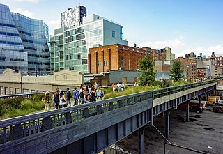
The High Line is a 1.45-mile-long (2.33 km) elevated linear park, greenway and rail trail created on a former New York Central Railroad spur on the west side of Manhattan in New York City. The High Line's design is a collaboration between James Corner Field Operations, Diller Scofidio + Renfro, and Piet Oudolf. The abandoned spur has been redesigned as a "living system" drawing from multiple disciplines which include landscape architecture, urban design, and ecology. The High Line was inspired by the 4.7 km (2.9 mi) long Coulée verte, a similar project in Paris completed in 1993.

The Hudson Line is a commuter rail line owned and operated by the Metro-North Railroad in the U.S. state of New York. It runs north from New York City along the east shore of the Hudson River, terminating at Poughkeepsie. The line was originally the Hudson River Railroad, and eventually became the Hudson Division of the New York Central Railroad. It runs along what was the far southern leg of the Central's famed "Water Level Route" to Chicago.

The Pennsylvania Railroad Station was the intermodal passenger terminal for the Pennsylvania Railroad's (PRR) vast holdings on the Hudson River and Upper New York Bay in Jersey City, New Jersey. By the 1920s the station was called Exchange Place. The rail terminal and its ferry slips were the main New York City station for the railroad until the opening in 1910 of New York Pennsylvania Station, made possible by the construction of the North River Tunnels. It was one of the busiest stations in the world for much of the 19th century.
St. John's Park was a 19th-century park and square, and the neighborhood of townhouses around it, in what is now the Tribeca neighborhood of Lower Manhattan, New York City. The square was bounded by Varick Street, Laight Street, Hudson Street and Beach Street, now also known for that block as Ericsson Place. Although the name "St. John's Park" is still in use, it is no longer a park and is inaccessible to the public.
Harsimus is a neighborhood within Downtown Jersey City, Hudson County, in the U.S. state of New Jersey. The neighborhood stretches from the Harsimus Stem Embankment on the north to Christopher Columbus Drive on the south between Coles Street and Grove Street or more broadly, to Marin Boulevard. It borders the neighborhoods of Hamilton Park to the north, Van Vorst Park to the south, the Village to the west, and the Powerhouse Arts District to the east. Newark Avenue has traditionally been its main street. The name is from the Lenape, used by the Hackensack Indians who inhabited the region and could be translated as Crow’s Marsh. From many years, the neighborhood was part of the "Horseshoe", a political delineation created by its position between the converging rail lines and political gerrymandering.

Spuyten Duyvil and Port Morris Railroad was a railroad built in what is today the West Bronx and South Bronx in New York City, United States. It ran from the junction between the West Side Line and the Hudson River Railroad near Spuyten Duyvil Creek, then along the Harlem River to the northwestern shore of the East River in what is today the Port Morris section of the Bronx.

St. John's Terminal, also known as 550 Washington Street, is a building on Washington Street in the Hudson Square neighborhood of Manhattan in New York City. Designed by Edward A. Doughtery, it was built in 1934 by the New York Central Railroad as a terminus of the High Line, an elevated freight line along Manhattan's West Side used for transporting manufacturing-related goods. The terminal could accommodate 227 train cars. The three floors, measuring 205,000 square feet (19,000 m2) each, were the largest in New York City at the time of their construction.