Related Research Articles
The Brooklyn Rapid Transit Company (BRT) was a public transit holding company formed in 1896 to acquire and consolidate railway lines in Brooklyn and Queens, New York City, United States. It was a prominent corporation and industry leader using the single-letter symbol B on the New York Stock Exchange.

Harlem–125th Street station is a commuter rail stop serving the Metro-North Railroad's Hudson, Harlem, and New Haven Lines. It is located at East 125th Street and Park Avenue in East Harlem, Manhattan, New York City. The station also serves as an important transfer point between the Metro-North trains and the New York City Subway's IRT Lexington Avenue Line for access to the Upper East Side of Manhattan. It is the only station besides Grand Central Terminal that serves all three lines east of the Hudson River. Trains leave for Grand Central Terminal, as well as to the Bronx and the northern suburbs, regularly.

23rd Street is a broad thoroughfare in the New York City borough of Manhattan, one of the major two-way, east-west streets in the borough's grid. As with Manhattan's other "crosstown" streets, it is divided into its east and west sections at Fifth Avenue. The street runs from Avenue C and FDR Drive in the east to Eleventh Avenue in the west.

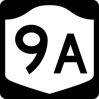
The Joe DiMaggio Highway, commonly called the West Side Highway and formerly the Miller Highway, is a 5.42-mile-long (8.72 km) mostly surface section of New York State Route 9A (NY 9A), running from West 72nd Street along the Hudson River to the southern tip of Manhattan in New York City. It replaced the West Side Elevated Highway, built between 1929 and 1951, which was shut down in 1973 due to neglect and lack of maintenance, and was dismantled by 1989. North of 72nd Street the roadway continues north as the Henry Hudson Parkway.

The Steinway Tunnel is a pair of tubes carrying the IRT Flushing Line of the New York City Subway under the East River between 42nd Street in Manhattan and 51st Avenue in Long Island City, Queens, in New York City. It was originally designed and built as an interurban trolley tunnel, with stations near the current Hunters Point Avenue and Grand Central stations.
The BMT Canarsie Line is a rapid transit line of the B Division of the New York City Subway system, named after its terminus in the Canarsie neighborhood of Brooklyn. It is served by the L train at all times, which is shown in medium gray on the New York City Subway map and on station signs.
The IND Sixth Avenue Line is a rapid transit line of the B Division of the New York City Subway in the United States. It runs mainly under Sixth Avenue in Manhattan, and continues south to Brooklyn. The B, D, F, and M trains, which use the Sixth Avenue Line through Midtown Manhattan, are colored orange. The B and D trains use the express tracks, while the F, <F> and M trains use the local tracks.
The BMT Sea Beach Line is a rapid transit line of the BMT division of the New York City Subway, connecting the BMT Fourth Avenue Line at 59th Street via a four-track wide open cut to Coney Island in Brooklyn. It has at times hosted the fastest express service between Manhattan and Coney Island, since there are no express stations along the entire stretch, but now carries only local trains on the N service, which serves the entire line at all times. During rush hours, several W trains serve the line north of 86th Street.

Tenth Avenue, known as Amsterdam Avenue between 59th Street and 193rd Street, is a north-south thoroughfare on the West Side of Manhattan in New York City. It carries uptown (northbound) traffic as far as West 110th Street, after which it continues as a two-way street.
Eleventh Avenue is a north–south thoroughfare on the far West Side of the borough of Manhattan in New York City, located near the Hudson River. Eleventh Avenue originates in the Meatpacking District in the Greenwich Village and West Village neighborhoods at Gansevoort Street, where Eleventh Avenue, Tenth Avenue, and West Street intersect. It is considered part of the West Side Highway between 22nd and Gansevoort Streets.

The Atlantic Terminal is the westernmost commuter rail terminal on the Long Island Rail Road's (LIRR) Atlantic Branch, located at Flatbush Avenue and Atlantic Avenue in Downtown Brooklyn, New York City. It is the primary terminal for the West Hempstead Branch, and a peak-hour terminal for some trains on the Hempstead Branch, Far Rockaway Branch, and the Babylon Branch; most other service is provided by frequent shuttles to Jamaica station. The terminal is located in the City Terminal Zone, the LIRR's Zone 1, and thus part of the CityTicket program.

The West Side Line, also called the West Side Freight Line, is a railroad line on the west side of the New York City borough of Manhattan. North of Penn Station, from 34th Street, the line is used by Amtrak passenger service heading north via Albany to Toronto; Montreal; Niagara Falls and Buffalo, New York; Burlington, Vermont; and Chicago. South of Penn Station, a 1.45-mile (2.33 km) elevated section of the line, abandoned since 1980, has been transformed into an elevated park called the High Line. The south section of the park from Gansevoort Street to 20th Street opened in 2009 and the second section up to 30th Street opened in 2011, while the final section to 34th Street opened in 2014.
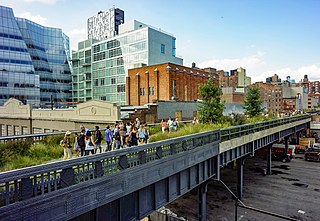
The High Line is a 1.45-mile-long (2.33 km) elevated linear park, greenway, and rail trail created on a former New York Central Railroad spur on the west side of Manhattan in New York City. The High Line's design is a collaboration between James Corner Field Operations, Diller Scofidio + Renfro, and Piet Oudolf. The abandoned spur has been redesigned as a "living system" drawing from multiple disciplines which include landscape architecture, urban design, and ecology. The High Line was inspired by the 4.7 km (2.9 mi) long Coulée verte, a similar project in Paris completed in 1993.
The West Side Elevated Highway was an elevated section of New York State Route 9A running along the Hudson River in the New York City borough of Manhattan to the tip of the island. It was an elevated highway, one of the first urban freeways in the world, and served as a prototype for urban freeways elsewhere, including Boston's Central Artery.
The Main Line is a rail line owned and operated by the Long Island Rail Road in the U.S. state of New York. It begins as a two-track line at Long Island City station in Long Island City, Queens, and runs along the middle of Long Island about 95 miles (153 km) to Greenport station in Greenport, Suffolk County. At Harold Interlocking approximately one mile east of Long Island City, the tracks from the East River Tunnels and 63rd Street Tunnel into Manhattan intersect with the Main Line, which most trains use rather than using the Long Island City station.

The Fifth Avenue Line, also called the Fifth Avenue Elevated or Fifth Avenue–Bay Ridge Line, was an elevated rail line in Brooklyn, New York City, United States. It ran above Hudson Avenue, Flatbush Avenue, Fifth Avenue, 38th Street, and Third Avenue from Downtown Brooklyn south to Bay Ridge. The portion on Third Avenue was called the Third Avenue Elevated to distinguish service from the elevated BMT West End Line; it was separate from the elevated IRT Third Avenue Line in Manhattan and the Bronx.

The Park Avenue main line, which consists of the Park Avenue Tunnel and the Park Avenue Viaduct, is a railroad line in the New York City borough of Manhattan, running entirely along Park Avenue. The line carries four tracks of the Metro-North Railroad as a tunnel from Grand Central Terminal at 42nd Street to a portal at 97th Street, where it rises to a viaduct north of 99th Street and continues over the Harlem River into the Bronx over the Park Avenue Bridge. During rush hours, Metro-North uses three of the four tracks in the peak direction.

The Evergreen Branch was a branch of the Long Island Rail Road (LIRR) that ran in Brooklyn and part of Queens in New York City. The line, at its fullest extent, ran between Greenpoint, Brooklyn and Ridgewood, Queens. The line consisted of two leased portions. The first portion, between Greenpoint and Jefferson Street, was leased from the Glendale and East River Railroad. The second portion, from Jefferson Street to Ridgewood, was leased from the Brooklyn and Rockaway Beach Railroad Company, and was known as the Evergreen Branch, a name later extended to the rest of the line.

The Bushwick Branch, also called the Bushwick Lead Track, is a freight railroad branch in New York City. It runs from the East Williamsburg neighborhood of Brooklyn to Fresh Pond Junction in the Glendale neighborhood of Queens, where it connects with the Montauk Branch of the Long Island Rail Road. It is owned by the LIRR but operated under lease by the New York and Atlantic Railway, which took over LIRR freight operations in May 1997.

St. John's Terminal, also known as 550 Washington Street, is a building on Washington Street in the Hudson Square neighborhood of Manhattan in New York City. Designed by Edward A. Doughtery, it was built in 1934 by the New York Central Railroad as a terminus of the High Line, an elevated freight line along Manhattan's West Side used for transporting manufacturing-related goods. The terminal could accommodate 227 train cars. The three floors, measuring 205,000 square feet (19,000 m2) each, were the largest in New York City at the time of their construction.
References
- 1 2 3 Dunlap, David W. (February 18, 2015). "New York City Rail Crossings Carry a Deadly Past". The New York Times. ISSN 0362-4331 . Retrieved February 12, 2018.
- 1 2 "The Highline: past and present". GeoWeb, Harvard University. May 13, 2010. Archived from the original on October 23, 2014. Retrieved October 23, 2014.
- 1 2 "High Line History". Friends of the High Line. Archived from the original on September 22, 2014. Retrieved August 2, 2009.
- ↑ Gray, Christopher (December 22, 2011). "When a Monster Plied the West Side". The New York Times . Archived from the original on May 17, 2014. Retrieved May 12, 2014.
The New York World referred to the West Side route as Death Avenue in 1892, long after the Park Avenue problem had been solved, saying 'many had been sacrificed' to 'a monster which has menaced them night and day.'
- 1 2 Amateau, Albert. "Newspaper was there at High Line's birth and now its rebirth". The Villager . Vol. 77, no. 48. Archived from the original on July 13, 2011. Retrieved August 12, 2011.
- 1 2 "' Death Ave.' Ends as Last Rusty Rail Goes; Huge West Side Improvement Completed" (PDF). The New York Times. June 26, 1941. ISSN 0362-4331 . Retrieved February 12, 2018.
- ↑ Walsh, Kevin (September 2012). ""High Line"'s Last Frontier". Forgotten NY . Archived from the original on October 24, 2014. Retrieved October 23, 2014.