
Glastonbury is a town and civil parish in Somerset, England, situated at a dry point on the low-lying Somerset Levels, 23 miles (37 km) south of Bristol. The town, which is in the Mendip district, had a population of 8,932 in the 2011 census. Glastonbury is less than 1 mile (2 km) across the River Brue from Street, which is now larger than Glastonbury.

Taunton is a town in Somerset, England, with a 2011 population of 69,570. Its thousand-year history includes a 10th-century monastery. Taunton Castle, risen in the Anglo-Saxon period, later became a priory. The Normans built a castle that belonged to the Bishops of Winchester; reconstructed parts of the inner ward now house the Museum of Somerset and Somerset Military Museum. During the Second Cornish uprising of 1497, Perkin Warbeck marched here an army of 6,000; most surrendered to Henry VII on 4 October 1497. On 20 June 1685 the Duke of Monmouth crowned himself King of England at Taunton in a rebellion defeated at the Battle of Sedgemoor. Judge Jeffreys led the Bloody Assizes in the Great Hall of the Castle. The Grand Western Canal reached Taunton in 1839 and the Bristol and Exeter Railway in 1842. Today it includes Musgrove Park Hospital, Somerset County Cricket Club and the headquarters of 40 Commando, Royal Marines. Taunton flower show has been held in Vivary Park since 1866. The United Kingdom Hydrographic Office is in Admiralty Way.

Glastonbury Abbey was a monastery in Glastonbury, Somerset, England. Its ruins, a grade I listed building and scheduled ancient monument, are open as a visitor attraction.

Froxfield is a village and civil parish in the English county of Wiltshire. The parish is on the Wiltshire-West Berkshire border, and the village lies on the A4 national route about 3 miles (4.8 km) west of Hungerford and 7.5 miles (12 km) east of Marlborough.
Durston is a village and civil parish in Somerset, England, situated on the A361 road 5 miles (8.0 km) north east of Taunton and 6 miles (9.7 km) south of Bridgwater in the Somerset West and Taunton district. The parish lies on undulating ground between the lowest slopes of the Quantock Hills and the valley of the River Tone at the Curry and Hay Moors. The parish has a population of 136.
Tolland is a village and civil parish in Somerset, England, situated 9 miles (14.5 km) north west of Taunton, between the Brendon Hills and Quantock Hills, in the Somerset West and Taunton district. The parish has a population of 81.

Mells is a village and civil parish in Somerset, England, near the town of Frome.
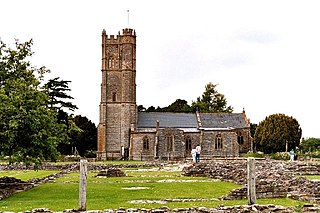
Muchelney Abbey is an English Heritage property in the village of Muchelney in the Somerset Levels, England. The site consists of ruined walls showing the layout of the abbey buildings constructed from the 7th to 16th and the remaining intact Abbott's House. It is next to the parish church in which some of the fabric of the abbey has been reused.
The Somerset Buildings Preservation Trust (SBPT) works to save the architectural heritage of Somerset, England.

Meare is a village and civil parish 3 miles (4.8 km) north west of Glastonbury on the Somerset Levels, in the Mendip district of Somerset, England. The parish includes the village of Westhay.

East Brent is a village and civil parish, on the eastern edge of a hill that dominates the surrounding level countryside—Brent Knoll—close to the M5 motorway, 5 miles (8 km) west of Axbridge, in the Sedgemoor district of the county of Somerset, in the south-west of England. The parish includes the hamlets of Rooksbridge, where the A38 road crosses the Mark Yeo and Edingworth.

The Grade I listed buildings in Somerset, England, demonstrate the history and diversity of its architecture. The ceremonial county of Somerset consists of a non-metropolitan county, administered by Somerset County Council, which is divided into five districts, and two unitary authorities. The districts of Somerset are West Somerset, South Somerset, Taunton Deane, Mendip and Sedgemoor. The two administratively independent unitary authorities, which were established on 1 April 1996 following the breakup of the county of Avon, are North Somerset and Bath and North East Somerset. These unitary authorities include areas that were once part of Somerset before the creation of Avon in 1974.

Gray's Almshouses is a terrace of almshouses in Taunton, Somerset, England, founded in 1635 by the wealthy cloth-merchant Robert Gray, whose monument survives in the Church of St Mary Magdalene. The building is one of the oldest surviving in Taunton and is one of the earliest brick buildings in the county. The Almshouses were designed to provide accommodation for six men and ten women and for a reader who was to act as chaplain and schoolmaster. It is a Grade I listed building as designated by English Heritage. Following renovation in the late twentieth century it now comprises sheltered accommodation of nine flats for the elderly.

The Abbot's Fish House in Meare, Somerset, England, was built in the 14th century and has been designated as a Grade I listed building and Scheduled Ancient Monument. It is the only surviving monastic fishery building in England.

The Manor Farmhouse in Meare, Somerset, England, was built in the 14th century as the summer residence of the Abbots from Glastonbury Abbey and is now a farmhouse. Along with its outbuildings the farmhouse has been designated as a Grade I listed building.
Richard Beere was an English Benedictine abbot of Glastonbury, known as a builder for his abbey, as a diplomat and scholar, and a friend of Erasmus.

St Joseph's Convent is a complex of 18th- and 19th-century buildings in Taunton, Somerset, which were primarily used as a Roman Catholic convent, first by the Franciscans, and then Sisters of St. Joseph of Annecy. The buildings were sold out of the Catholic church in 1976, and were redeveloped as residential flats in 2005. The main building is designated by English Heritage as a Grade II* listed building, while the boundary walls on the west side are Grade II listed.

The Hospital of St Mary Magdalene in Glastonbury, Somerset, England was built around 1310 by Glastonbury Abbey. It is a Grade II* listed building, and part has been scheduled as an ancient monument.
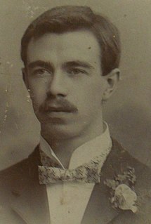
William Edwin Worrall (1877-1940) was a Staffordshire-born designer of fabric, pottery, glass and stoneware. He was the brother of the watercolour painter Thomas Frederick Worrall and shared similar artistic ability.


