
Reading School is a state grammar school for boys with academy status in the English town of Reading, the county of Berkshire. It traces its history back to the school of Reading Abbey and is, thus, one of the oldest schools in England, although it closed for a few years in the 1860s. It is a state boarding school. There are no tuition fees for day pupils, and boarders only pay for food and lodging. Reading is one of the best state schools in the UK according to the GCSE and A-level tables and has consistently ranked in the top ten.
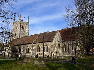
Reading Minster, or the Minster Church of St Mary the Virgin, is the oldest ecclesiastical foundation in the town of Reading, Berkshire, England. Although eclipsed in importance by the later Reading Abbey, Reading Minster regained its status after the destruction of the Abbey and is now an Anglican parish church.

Prospect Park is a public park in the western suburbs of Reading situated north of the Bath Road in the English county of Berkshire. It is the largest park in Reading, and includes a large regency style house, now known as Prospect Park Mansion House and previously as Prospect House. There are also sporting facilities and the Prospect Park Miniature Railway within the 50 hectares of parkland, and a restaurant in the Mansion House.
Oxford Road is an urban street and major arterial road in Reading, Berkshire, England, Beginning near the town centre at the meeting of St. Mary's Butts/West Street/Broad Street. The road leads west to Pangbourne, continuing eventually to the city of Oxford. The road was previously known as Pangbourne Lane.

Greyfriars Church is an evangelical Anglican church, and former Franciscan friary, in the town centre of Reading in the English county of Berkshire. The church forms part of the Church of England's Diocese of Oxford.

Reading Civic Centre was a civic centre in the town of Reading, itself in the English county of Berkshire. The centre dated from the mid-1970s.
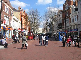
Broad Street is a main pedestrianised thoroughfare and the primary high street in the English town of Reading. The street is situated in the town centre, running for approximately 0.25 miles (0.40 km), from west to east. The western end of the road lies at the crossroads with Oxford Road, West Street and St Mary's Butts. The eastern end continues as King Street after the junction with Minster Street and Butter Market.

Watlington House is a 17th-century building, with a large walled garden, in the town of Reading in the English county of Berkshire. The building is brick built and is reputed to be the oldest surviving secular building in the town. It is a listed building, being listed grade II*. The information on the Historic England website is https://historicengland.org.uk/listing/the-list/list-entry/1321898

Reading Town Hall is the town hall of Reading, Berkshire, England. The town hall was built in several phases between 1786 and 1897, although the principal facade was designed by Alfred Waterhouse in 1875. Situated close to the site of Reading Abbey, it is adjoined to the north by the Hospitium of St John and to the south by St Laurence's Church.

Friar Street is a thoroughfare in the English town of Reading. It runs parallel to Broad Street, connected by Union Street, Queen Victoria Street and Cross Street. At the western end is the Greyfriars Church and at the eastern end are the Town Hall and St Laurence's Church.

Queen Victoria Street is a pedestrianised thoroughfare in the English town of Reading, Berkshire. It connects Broad Street with Friar Street and Station Road.
The Oracle was a workhouse that produced cloth in the English town of Reading, Berkshire. The Oracle shopping centre, which now occupies a small part of the site, takes its name from the Oracle workhouse.

The George Hotel is a hotel and former coaching inn in the town of Reading in the English county of Berkshire. It is situated at the eastern end of the town centre, on the corner of King Street and Minster Street, next to The Oracle shopping mall. It is a Grade II listed building.

The Malmaison Hotel Reading is a grade II listed hotel in the town of Reading in the English county of Berkshire. It is situated at the junction of Blagrave Street and Station Road, directly opposite the main entrance to Reading railway station. It was opened in 1844, shortly after the Great Western Railway opened its line from London, and is thought to be the oldest surviving purpose-built railway hotel in the world.

High Bridge, sometimes known as Duke Street Bridge, is a bridge across the River Kennet in the town centre of Reading in the English county of Berkshire. It links Duke Street, to its north, and London Street, to its south. High Bridge is the oldest surviving bridge across the Kennet, and is a grade II listed building. It comprises a single arch of vermiculated Portland stone, with a plain keystone of ashlar.

St Peter's Church is a Church of England parish church in Caversham, a suburb of Reading in the English county of Berkshire. It is situated close to the River Thames in Caversham Heights.
Occupation at the site of Reading may date back to the Roman period, possibly as either a trading port on the River Thames, or as an intersection on the Roman road connecting London with Calleva Atrebatum near Silchester.
Adam de Lathbury, O.S.B., otherwise known as Adam of Lathbury or Adam Lothbury, was a Benedictine monk who ruled as Abbot of Reading Abbey, in the English county of Berkshire, from 1226 to 1238.
Samuel Watlington was a cloth merchant and leading citizen of the town of Reading in the English county of Berkshire. He held the office of Mayor of Reading in 1695 and 1711. In 1688, he and his wife Anne had Watlington House, reputed to be the oldest surviving secular building in Reading, built.

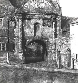
The Hospitium of St John the Baptist was the hospitium, or dormitory for pilgrims, of Reading Abbey, which today is a large, ruined abbey in the centre of the town of Reading, in the English county of Berkshire. The hospitium was founded in 1189, and at its maximum comprised a range of buildings that could accommodate 400 people. The main building has survived, and is grade II listed. Much of the remainder of the original hospitium was located where Reading Town Hall now stands.

