Esholt is a village and former civil parish in the metropolitan district of the City of Bradford, West Yorkshire, England. It is situated 3 miles (4.8 km) east of Shipley town centre, 1.5 miles (2.4 km) south-west of the A65 in Guiseley, 7 miles (11 km) north of Bradford City Centre, and 10 miles (16 km) north-west of Millennium Square, Leeds.

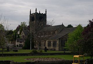
Guiseley is a town in metropolitan borough of the City of Leeds, West Yorkshire, England. Historically part of the West Riding of Yorkshire, it is situated south of Otley and Menston and is now a north-western suburb of Leeds.

Yeadon is a town within the metropolitan borough of the City of Leeds, West Yorkshire, England.
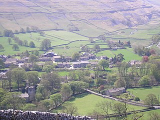
Arncliffe is a small village and civil parish in Littondale, one of the Yorkshire Dales in England. Littondale is a small valley beside Upper Wharfedale, 3 miles (4.8 km) beyond Kilnsey and its famous crag. It is part of the Craven district of the non-metropolitan county of North Yorkshire, but is in the historic West Riding of Yorkshire. The population of the civil parish was estimated at 80 in 2015.

Horsforth is a town and civil parish in the City of Leeds, West Yorkshire, England, five miles north-west of Leeds city centre. Historically a village within the West Riding of Yorkshire, it had a population of 18,895 at the 2011 Census. It became part of the City of Leeds metropolitan borough in 1974. In 1999, a civil parish was created for the area, and the parish council voted to rename itself a town council. The area is within the Horsforth ward of Leeds City Council, which also includes the southern part of Rawdon.

Adel is a suburb of Leeds, West Yorkshire, England. To its immediate south is Weetwood, to the west are Cookridge and Holt Park, to the east are Alwoodley and Moortown, and to the north are Bramhope, Arthington and Eccup.

The Wharfedale line is one of the rail services in the West Yorkshire Metro area of northern England. The service connects Ilkley with Leeds and Bradford, and is operated by Northern Trains. West Yorkshire Metrocards are available for use on the line, covering Zones 3–5. The line is served predominantly by four-coach Class 333 electric multiple units.

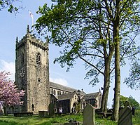
Rawdon is a village and civil parish in the metropolitan borough of the City of Leeds, West Yorkshire, England. It sits on the River Aire and on the A65 south of Yeadon.
Church of All Saints is the Anglican parish church in the town of Bingley, West Yorkshire, England. It is one of two Anglican churches in the town, the other being Holy Trinity. All Saints has existed since Norman times and it is set in the oldest part of the town, near to where the River Aire is crossed by Ireland Bridge.
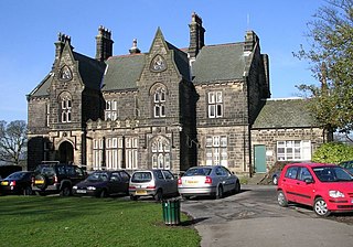
Aireborough was a local government district in the West Riding of Yorkshire, England from 1937 to 1974. It was formed through the abolition of the urban districts of Guiseley, Yeadon and Rawdon and enlarged by the addition of parts of Otley urban district and parts of the civil parishes of Esholt, Hawksworth and Menston in the Wharfedale rural district on 1 April 1937. Aireborough Urban District was administered from Micklefield House in Rawdon which had been acquired by Rawdon UDC in 1930. The district is, since 1974, part of Leeds and Esholt is in Bradford

Burley is an inner city area of Leeds, West Yorkshire, England, 1 mile (1.6 km) north-west of Leeds city centre, between the A65 Kirkstall Road at the south and Headingley at the north, in the Kirkstall ward.

St Chad's Church, Far Headingley is the parish church of Far Headingley in Leeds, West Yorkshire, England. The church is Grade II* listed in Gothic Revival style. The dedication is to Chad of Mercia, who was bishop of York and died in AD 672. It is set back from the busy Otley Road, with a cricket field and the parish war memorial nearer the road.
West Yorkshire is a metropolitan county in the Yorkshire and the Humber region of England. Created as a metropolitan county in 1974 after the passage of the Local Government Act 1972, it consists of five metropolitan boroughs, namely the City of Bradford, Calderdale, Kirklees, the City of Leeds and the City of Wakefield. Its area corresponds approximately with the historic West Riding of Yorkshire, and it contains the major towns of Bradford, Dewsbury, Halifax, Huddersfield, Leeds, and Wakefield.
St Oswald's Church is an active Anglican church in Collingham, West Yorkshire, England. It is in the Harrogate deanery and Diocese of Leeds. The church is on the edge of the village on Wetherby Road.

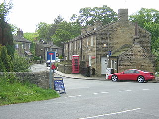
Hawksworth is a village 1 mile (1.6 km) west of the town of Guiseley in West Yorkshire, England. It is located to the south of Menston and north of Baildon.
St Saviour Church in Richmond Hill, Leeds, West Yorkshire, England is an active Anglican parish church in the archdeaconry of Leeds and the Diocese of Leeds.
William Rookes Crompton-Stansfield of Esholt Hall, Yorkshire, and Frimley Park, Surrey, was a British landowner and Whig politician who was MP for Huddersfield, Yorkshire, from 1837 to 1853.

The Church of St Oswald, Filey, is a parish church in the North Yorkshire town of Filey, England. The church dates from the 12th and 13th centuries, with some embattlements added in the 15th century. The building is now grade I listed and was described by Pevsner as "easily the finest church in the north-east corner of the East Riding".
Guiseley and Rawdon is a ward in the metropolitan borough and Rawdon is a civil parish in the City of Leeds, West Yorkshire, England. This list also contains the listed buildings in Otley and Yeadon ward. The wards and parish contain 99 listed buildings that are recorded in the National Heritage List for England. Of these, one is listed at Grade I, the highest of the three grades, three are at Grade II*, the middle grade, and the others are at Grade II, the lowest grade. The wards and parish contain the towns of Guiseley and Yeadon, the villages of Rawdon and Hawksworth, and the surrounding area. Most of the listed buildings are houses, cottages and associated structures, farmhouses and farm buildings. The other listed buildings include churches and items in churchyards, a village cross, a school, a former hospital, a railway bridge, a railway tunnel portal and retaining walls, a former tram shed, a town hall, and a telephone kiosk.