
The Isle of Man is an island in the Irish Sea, between Great Britain and Ireland in Western Europe, with a population of almost 85,000. It is a British Crown dependency. It has a small islet, the Calf of Man, to its south. It is located at 54°15′N4°30′W.

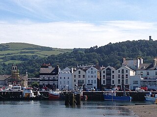
Peel is a seaside town and small fishing port in the Isle of Man, in the historic parish of German but administered separately. Peel is the third largest town in the island after Douglas and Ramsey but the fourth largest settlement, as Onchan has the second largest population but is classified as a village. Until 2016 Peel was also a House of Keys constituency, electing one Member of the House of Keys (MHK), who, from September 2015, was Ray Harmer. Peel has a ruined castle on St Patrick's Isle, and a cathedral, seat of the Diocese of Sodor and Man.
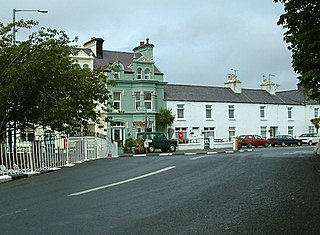
Ramsey is a coastal town in the north of the Isle of Man. It is the second largest town on the island after Douglas. Its population is 7,845 according to the 2016 census. It has one of the biggest harbours on the island, and has a prominent derelict pier, called the Queen's Pier. It was formerly one of the main points of communication with Scotland. Ramsey has also been a route for several invasions by the Vikings and Scots.

Ramsey A.F.C. is a football club from Ramsey on the Isle of Man. They compete in the Isle of Man Football League and they wear a blue and white kit, and a change strip of all red. They play their home games at the Ballacloan Stadium in Ramsey.

St Johns United A.F.C. are a football club from St John's on the Isle of Man. They compete in the Isle of Man Football League. They play in a royal blue and yellow striped kit and play their home games at Mullen-y-Cloie in St John's.
Ballaugh is a small village on the Isle of Man in the parish of the same name, in the sheading of Michael. It is the only village in the parish.

Garff is one of the six sheadings of the Isle of Man.

Lezayre, formally Kirk Christ Lezayre, is one of the seventeen historic parishes of the Isle of Man.
One of the characteristics of the Isle of Man Railway are the numerous level crossings and farm crossings along the various routes; many smaller crossing places are marked only by gates the criss-cross farm land and provide access to individual private roads which connect the farms to the main roads. Being largely rural in nature the railway has many of these scattered along the existing South Line, and there were, as one might expect, many more on the closed sections of the railway. These can be summarised as follows, along with other points of interest along the line not covered in the Isle of Man Railway stations section:-

Lezayre Station was an intermediate stopping place on the Manx Northern Railway, a line that ran between St. John's and Ramsey in the Isle of Man. It was the first halt outside the terminus at Ramsey. It was later owned and operated by the Isle of Man Railway. It served the small village known as Churchtown centred on the parish church, Kirk Christ Lezayre.

Ramsey pier is 2,241 ft long and was built for the Isle of Man Harbour Board for the sum of £40,752 by Head Wrighton of Stockton-on-Tees, England. The designer was Sir John Coode, who later became president of the Institution of Civil Engineers. Construction work began in 1882 and the pier was officially opened on 22 July 1886 by Rowley Hill, Bishop of Sodor and Man, though it had already been in use for about one year whilst being finished. The pier was originally intended as a landing stage to allow Steam Packet ships to pick up or discharge passengers when the tide was low. At low water spring tides you could expect about 16 ft at the pier head, enough for ships of about 250 ft in length to pick up their passengers.

Highroads Course was a road-racing circuit used for the Gordon Bennett British Eliminating Trial held in the Isle of Man for the 1904 and 1905 Tourist Trophy Race involving touring automobiles and cars. The events were held on public roads closed for racing by an Act of Tynwald.
The Isle of Man has had a number of windmills over the centuries. They were mostly threshing mills, with a few corn mills.

Quarterbridge is situated soon after the 1 mile-marker measured from the TT Grandstand, part of the Snaefell Mountain Course used for the Isle of Man TT races, at the junction of the primary A1 Douglas to Peel road, A2 Douglas to Ramsey road and the A5 Douglas to Port Erin road which forms the boundary between the parishes of Braddan and Onchan in the Isle of Man.

The Isle of Man Sea Terminal is the arrival and departure point for all passenger and car ferries operating to and from the Isle of Man, and is located in Douglas, the island's capital. It is one of the two main gateways to the Isle of Man, the other one being the Isle of Man Airport. It is operated by and is the main hub for the Isle of Man Steam Packet Company, which runs year-round sailings to Heysham, and seasonal sailings to Liverpool, Belfast and Dublin in the summer and Birkenhead at weekends in the winter.
This is a list of Registered Buildings and Conservation Areas of the Isle of Man. It includes buildings and structures in the Isle of Man designated by Isle of Man's Department of Environment, Food and Agriculture (DEFA) "as having special architectural or historical interest". Over 250 buildings and structures are listed, and 275 more have been identified as having potential for listing. It also lists the 21 Conservation Areas, historic districts" which protect "period"-type architecture, quality of building materials, relationships of enclosures and open spaces, and other aspects of the look and feel of historic buildings and areas.
The King William Banks are a series of sand banks 14 mi Northeast of Ramsey, Isle of Man.
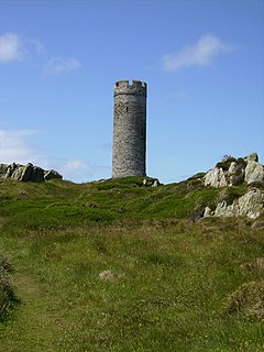
The Herring Tower is situated on the Langness Peninsula in the south of the Isle of Man. It was built by Thomas Brine in 1823. The tower was built as a daymark and was based on the style of the tower of Peel Castle. Since 1991 the Herring Tower has been protected as a registered building.
Onchan Village Hall is one of eleven buildings in the Isle of Man known to have been built by Baillie Scott. The Scottish architect and designer then resident on the Isle of Man had won the commission for the building through a design competition held by Onchan Commissioners for the proposed new hall. The building was constructed in 1897-8 and it is still in regular use today.

The Albert Tower on the Isle of Man is a historic monument which is one of Isle of Man's Registered Buildings. It was registered on 27 January 2003 as number 214.
