St Vincent's Hospital (Brisbane)

Last updated

St. Vincent's Private Hospital (Brisbane)
Sisters of Charity of Australia
St Vincent's Hospital (Brisbane).jpg
St Vincent's Hospital (Brisbane)
Geography
Location Kangaroo Point, Brisbane, QLD, Australia
Services
Beds164
History
Opened1954 (founded), 1957(opened)
Links
Website www.svphb.org.au
Lists Hospitals in Australia

St Vincent's Private Hospital Brisbane (formerly known as Mount Olivet Hospital) is a hospital located in the suburb of Kangaroo Point in Brisbane, Queensland, Australia. [1]

Contents

Mount Olivet Hospital was established in 1957 as a hospice for the terminally ill. It was renamed in 2008 to emphasize its continuity with other hospitals belonging to St Vincent's Health Australia, the largest Catholic non-profit healthcare provider. [2] [3]

The hospital redevelopment to increase its capacity and expand services was completed in 2010.

History

Mary Josephine Bedford, Brisbane, c1954 Josephine Bedford Brisbane, c1954.jpg
Mary Josephine Bedford, Brisbane, c1954

The land on which the hospital stands originally belonged to Dr Lilian Violet Cooper, Queensland's first female doctor and surgeon. After her death in 1947, Dr Cooper's lifelong friend Mary Josephine Bedford donated the land to the Sisters of Charity to establish a hospice for the sick and dying, particularly for those who were poor. [4] [5]

Transport

The hospital is accessible by bus

Related Research Articles

<span class="mw-page-title-main">Kangaroo Point, Queensland</span> Suburb of Brisbane, Queensland, Australia

Kangaroo Point is an inner southern suburb in the City of Brisbane, Queensland, Australia. In the 2021 census, Kangaroo Point had a population of 9,689 people.

<span class="mw-page-title-main">Chermside, Queensland</span> Suburb of Queensland, Australia

Chermside is a suburb in the City of Brisbane, Queensland, Australia. The suburb is situated 9.8 kilometres (6.1 mi) by road north of the Brisbane CBD. It is home to a large Westfield shopping centre. In the 2021 census, Chermside had a population of 11,426 people.

<span class="mw-page-title-main">Herston, Queensland</span> Suburb of Brisbane, Queensland, Australia

Herston is an inner suburb of the City of Brisbane, Queensland, Australia. In the 2021 census, Herston had a population of 2,311 people.

<span class="mw-page-title-main">Coorparoo, Queensland</span> Suburb of Brisbane, Queensland, Australia

Coorparoo is a suburb in the inner City of Brisbane, Queensland, Australia. In the 2021 census, Coorparoo had a population of 18,132 people.

<span class="mw-page-title-main">South Brisbane, Queensland</span> Suburb of Brisbane, Queensland, Australia

South Brisbane is an inner southern suburb in the City of Brisbane, Queensland, Australia. In the 2021 census, South Brisbane had a population of 14,292 people.

<span class="mw-page-title-main">South East Busway</span> Bus-only road in Queensland, Australia

The South East Busway is a grade separated bus-only road running south from the Brisbane central business district to Eight Mile Plains in Queensland, Australia. The busway was completed to Woolloongabba in September 2000 and to Eight Mile Plains in April 2001. An extension of the busway to School Road at Rochedale was completed in 2014 with no additional busway stations. The maximum capacity of the busway is 18,000 commuters an hour during peak periods. The busway carries an estimated 70 million passengers annually.

<span class="mw-page-title-main">Dutton Park, Queensland</span> Suburb of Brisbane, Queensland, Australia

Dutton Park is an inner southern suburb in the City of Brisbane, Queensland, Australia. In the 2021 census, Dutton Park had a population of 2,134 people.

<span class="mw-page-title-main">Sunnybank, Queensland</span> Suburb of Brisbane, Queensland, Australia

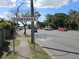
Sunnybank is a suburb in the City of Brisbane, Queensland, Australia. It is known for its many Asian shops and restaurants.

<span class="mw-page-title-main">Woolloongabba</span> Suburb of Brisbane, Queensland, Australia

Woolloongabba is an inner southern suburb in the City of Brisbane, Queensland, Australia. In the 2021 census, Woolloongabba had a population of 8,687 people.

<span class="mw-page-title-main">Camp Hill, Queensland</span> Suburb of Brisbane, Queensland, Australia

Camp Hill is a suburb in the City of Brisbane, Queensland, Australia. In the 2021 census, Camp Hill had a population of 12,254 people.

<span class="mw-page-title-main">Wynnum, Queensland</span> Suburb of Brisbane, Queensland, Australia

Wynnum is a coastal suburb in the City of Brisbane, Queensland, Australia. The suburb is a popular destination in Brisbane due to its coastline, jetty and tidal wading pool. In the 2021 census, Wynnum had a population of 14,036 people.

<span class="mw-page-title-main">Greenslopes, Queensland</span> Suburb of Brisbane, Queensland, Australia

Greenslopes is a southern suburb in the City of Brisbane, Queensland, Australia. It is 6.0 kilometres (3.7 mi) by road south of the Brisbane CBD. In the 2021 census, Greenslopes had a population of 7,941 people.

<span class="mw-page-title-main">Spring Hill, Queensland</span> Suburb of Brisbane, Queensland, Australia

Spring Hill is an inner northern suburb in the City of Brisbane, Queensland, Australia. In the 2021 census, Spring Hill had a population of 6,593 people.

<span class="mw-page-title-main">East Brisbane, Queensland</span> Suburb of Brisbane, Queensland, Australia

East Brisbane is an inner southern suburb of the City of Brisbane, Queensland, Australia. In the 2021 census, East Brisbane had a population of 6,186 people.

<span class="mw-page-title-main">Banyo, Queensland</span> Suburb of Brisbane, Queensland, Australia

Banyo is a northern suburb in the City of Brisbane, Queensland, Australia. In the 2021 census, Banyo had a population of 6,105 people.

<span class="mw-page-title-main">Logan Road</span> Road in Brisbane, Australia

Logan Road, allocated state routes 95 and 30, is a major road in Brisbane, Queensland. It runs 18 kilometres (11 mi) from Springwood in Logan City to Woolloongabba in Brisbane, with most of the route signed as state route 95. The route was formerly the main route to the Gold Coast from Brisbane, until the South East Freeway was built.

<span class="mw-page-title-main">Nudgee, Queensland</span> Suburb of Brisbane, Queensland, Australia

Nudgee is a north-eastern suburb in the City of Brisbane, Queensland, Australia. In the 2021 census, Nudgee had a population of 4,377 people.

<span class="mw-page-title-main">Cannon Hill, Queensland</span> Suburb of Brisbane, Queensland, Australia

Cannon Hill is a suburb in the City of Brisbane, Queensland, Australia. In the 2021 census, Cannon Hill had a population of 6,701 people.

<span class="mw-page-title-main">Coopers Plains, Queensland</span> Suburb of Brisbane, Queensland, Australia

Coopers Plains is a southern suburb in the City of Brisbane, Queensland, Australia. In the 2021 census, Coopers Plains had a population of 5,675 people.

<span class="mw-page-title-main">Salisbury, Queensland</span> Suburb of Brisbane, Queensland, Australia

Salisbury is a southern suburb in the City of Brisbane, Queensland, Australia. In the 2021 census, Salisbury had a population of 6,790 people.

References

  1. "St. Vincent's Hospital Brisbane". St Vincent's Hospital (Brisbane). Archived from the original on 24 July 2009. Retrieved 7 January 2009.
  2. Rosemary Desmond, Upgraded Brisbane hospital gets new name, 'Sydney Morning Herald', February 19, 2008.
  3. "Mission vision values". St Vincent’s Private Hospitals. Archived from the original on 22 March 2022. Retrieved 17 July 2022.
  4. "Our Story". St Vincent's Hospital (Brisbane). Archived from the original on 29 October 2013. Retrieved 28 October 2013.
  5. "Launch £270,000 hospital appeal". The Courier-Mail . Brisbane: National Library of Australia. 22 June 1953. p. 6. Archived from the original on 17 July 2022. Retrieved 28 October 2013.

27°28′24″S153°02′06″E / 27.473356°S 153.0349557°E / -27.473356; 153.0349557