Related Research Articles
el-Djerid, also al-Jarīd, or more precisely the South Western Tunisia Region is a semi-desert natural region comprising three southern Tunisian Governorates, Gafsa, Kebili and Tozeur with adjacent parts of Algeria and Libya.

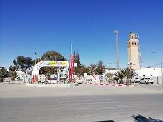
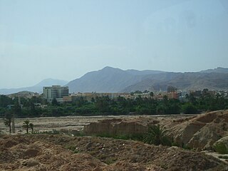
Gafsa is the capital of Gafsa Governorate of Tunisia. With a population of 111,170, Gafsa is the ninth-largest Tunisian city and it is 335 kilometers from the capital Tunis.
Sened is a commune and small town in central Tunisia in Gafsa Governorate, and is also the name of the extinct Berber language (Sened) that was spoken there and at the nearby town of Tmagourt until the mid-twentieth century. At the 2014 census it had a population of 9,581. In 1911, the whole town spoke Berber; by 1968, only the elderly did.
El Gawafel Sportives de Gafsa, known as EGS Gafsa or simply EGSG for short, is a Tunisian football club based in Gafsa. The club was founded in 1967 and its colours are green and yellow. Their home stadium, Gafsa Olympic Stadium, has a capacity of 7,000 spectators. The club is currently playing in the Tunisian Ligue Professionnelle 1.

Gafsa Governorate is one of the 24 governorates of Tunisia. It is situated in central Tunisia, bordering Algeria. It covers an area of 7807 km2 and has a population of 337,331. The capital of the city is Gafsa - ruled by Nader Hamdouni - whom all the heads of local municipalities report to.
The University of Sfax is a university located in Sfax, Tunisia. It was founded in 1986 under the name University of the South with the purpose of covering all academic institutions in Southern Tunisia. It is divided into three universities, including the current University of Sfax, with the creation of the University of Gabes in 2003 and the University of Gafsa in 2004.
Métlaoui is a town and commune in the Gafsa Governorate, Tunisia. In 2014 it had a population of 38,634.
Moularès is a town and commune in the Gafsa Governorate, Tunisia. At the 2004 census, it had a population of 24,487.

Redeyef is a town and commune in the Gafsa Governorate, Tunisia. As of 2004 it had a population of 26,143. City industry is mainly based on mining.
Fériana is a town and commune in the Kasserine Governorate, Tunisia. As of 2004 it had a population of 26,504. It is 35 km from Kasserine and 75 from Gafsa.

Bir El Hafey is a town and commune located at 34°55′48″N 9°12′00″E in the Sidi Bouzid Governorate, in Tunisia. As of 2004 it had a population of 6,405.
Mezzouna is a town and commune in the Sidi Bou Zid Governorate, Tunisia. As of 2004, it had a population of 6,101.
The University of Gafsa is a public university located in Gafsa, Tunisia. The university is oriented primarily toward sciences and information technology
Sidi Aïch is a small town, located at 35° 13′ 47″ N, 9° 07′ 46″ E in south-central Tunisia, it belongs to Gafsa Governorate and it is located in 29 km in the north of Gafsa.
Hassi El Ferid is a town and commune in the Kasserine Governorate, Tunisia. As of 2004 it had a population of 4 711. It is 35 km from Kasserine and 75 from Gafsa.
Lac de Gafsa, also called 'Mysterious Lake', appeared unexpectedly in 2014 alongside Om Laryes Road, 25 kilometers from the town of Gafsa in Tunisia. The origin or formation of the lake is not clear. The most likely explanation is that a minor earthquake had ruptured the rock above the water table sending millions of cubic meters of water up to the surface.
Djebel Bouramli is a mountain located in the governorate of Gafsa, in the south-west of Tunisia.
The Établissement de la Radio Tunisienne is Tunisia's state-owned public radio broadcaster. It was formed in August 2007, when the former national state broadcaster ERTT was split into separate radio and television companies. Tunisian Radio operates ten stations, four nationwide and six regionally. It is an active member of the European Broadcasting Union (EBU).

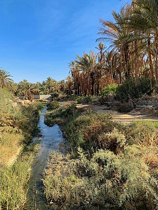
Gafsa Oases are date palm oases at Gafsa in southwestern Tunisia, near the northern edge of the Sahara Desert. The Gafsa Oases were known to the ancient Romans and cover approximately 700 hectares. The oases were designated a Globally Important Agricultural Heritage System in 2011. The individual oases are called Sakdoud, Ksar, Lela, Gafsa and El Guettar.
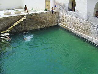
The Roman baths of Gafsa are well-preserved remnants of the Limes Tripolitanus era of North African history, when Gafsa, Tunisia was called Capsa. According to a history of water in the Roman world, "there are two open-air central pools" in part because it was a Trajanic colony. The baths and the nearby Gafsa Oases were both established because of a local spring that emerges from the nearby mountains. Sallust mentioned the oasis/settlement existing circa 100 BC. A "Byzantine fortress" also remains.
References
34°25′21″N8°46′18″E / 34.42250°N 8.77167°E
| | This article about a Tunisian sports venue is a stub. You can help Wikipedia by expanding it. |