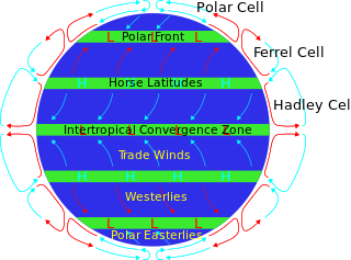
The horse latitudes are the latitudes about 30 degrees north and south of the Equator. They are characterized by sunny skies, calm winds, and very little precipitation. They are also known as subtropical ridges or highs. It is a high-pressure area at the divergence of trade winds and the westerlies.
The North Atlantic Oscillation (NAO) is a weather phenomenon over the North Atlantic Ocean of fluctuations in the difference of atmospheric pressure at sea level (SLP) between the Icelandic Low and the Azores High. Through fluctuations in the strength of the Icelandic Low and the Azores High, it controls the strength and direction of westerly winds and location of storm tracks across the North Atlantic.

Sea surface temperature (SST), or ocean surface temperature, is the ocean temperature close to the surface. The exact meaning of surface varies in the literature and in practice. It is usually between 1 millimetre (0.04 in) and 20 metres (70 ft) below the sea surface. Sea surface temperatures greatly modify air masses in the Earth's atmosphere within a short distance of the shore. Local areas of heavy snow can form in bands downwind of warm water bodies within an otherwise cold air mass. Warm sea surface temperatures can develop and strengthen cyclones over the ocean. Tropical cyclones can also cause a cool wake. This is due to turbulent mixing of the upper 30 metres (100 ft) of the ocean. Sea surface temperature changes during the day. This is like the air above it, but to a lesser degree. There is less variation in sea surface temperature on breezy days than on calm days. The thermohaline circulation has a major impact on average sea surface temperature throughout most of the world's oceans.
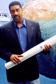
Evan B. Forde is an American oceanographer at the Atlantic Oceanographic & Meteorological Laboratory (AOML) with the National Oceanic & Atmospheric Administration (NOAA). He was the first African-American scientist to perform research in a submersible. Forde is widely considered an expert on the formation of submarine canyons and his recent research uses satellite sensors to analyze atmospheric conditions related to hurricane formation.

Kevin Edward Trenberth worked as a climate scientist in the Climate Analysis Section at the US National Center for Atmospheric Research (NCAR). He was a lead author of the 1995, 2001 and 2007 IPCC assessment reports. He also played major roles in the World Climate Research Programme (WCRP), for example in its Tropical Oceans Global Atmosphere program (TOGA), the Climate Variability and Predictability (CLIVAR) program, and the Global Energy and Water Exchanges (GEWEX) project.

William "Bill" Mason Gray was emeritus professor of atmospheric science at Colorado State University (CSU), and the head of the Tropical Meteorology Project at CSU's Department of Atmospheric Sciences. He is widely regarded as a pioneer in the science of tropical cyclone forecasting and one of the world's leading experts on tropical storms. After retiring as a faculty member at CSU in 2005, Gray remained actively involved in both climate change and tropical cyclone research until his death.

The Western Hemisphere Warm Pool (WHWP) is a region of sea surface temperatures (SST) warmer than 28.5 °C that develops west of Central America in the spring, then expands to the tropical waters to the east.
The Atlantic Oceanographic and Meteorological Laboratory (AOML), a federal research laboratory, is part of the National Oceanic and Atmospheric Administration's (NOAA) Office of Oceanic and Atmospheric Research (OAR), located in Miami in the United States. AOML's research spans tropical cyclone and hurricanes, coastal ecosystems, oceans and human health, climate studies, global carbon systems, and ocean observations. It is one of seven NOAA Research Laboratories (RLs).

Kerry Andrew Emanuel is an American professor of meteorology currently working at the Massachusetts Institute of Technology in Cambridge. In particular he has specialized in atmospheric convection and the mechanisms acting to intensify hurricanes.

An Atlantic hurricane is a type of tropical cyclone that forms in the Atlantic Ocean primarily between June and November. The terms "hurricane", "typhoon", and "cyclone" can be used interchangeably to describe this weather phenomenon. These storms are rotating, organized systems of clouds and thunderstorms that originate over tropical or subtropical waters and have closed low-level circulation, not to be confused with tornadoes. They form over low pressure systems. In the North Atlantic, central North Pacific, and eastern North Pacific, the term "hurricane" is mainly used, whereas "typhoon" is more commonly used for storms originating in the western North Pacific. The term "cyclone" is used in the South Pacific and Indian Ocean.

Christopher William "Chris" Landsea is an American meteorologist, formerly a research meteorologist with the Hurricane Research Division of the Atlantic Oceanographic and Meteorological Laboratory at NOAA, and now the Science and Operations Officer at the National Hurricane Center. He is a member of the American Geophysical Union and the American Meteorological Society.

Tropical cyclogenesis is the development and strengthening of a tropical cyclone in the atmosphere. The mechanisms through which tropical cyclogenesis occurs are distinctly different from those through which temperate cyclogenesis occurs. Tropical cyclogenesis involves the development of a warm-core cyclone, due to significant convection in a favorable atmospheric environment.
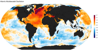
The Atlantic Multidecadal Oscillation (AMO), also known as Atlantic Multidecadal Variability (AMV), is the theorized variability of the sea surface temperature (SST) of the North Atlantic Ocean on the timescale of several decades.

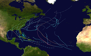
The 2012 Atlantic hurricane season was the final year in a string of three consecutive very active seasons since 2010, with 19 tropical storms. The 2012 season was also a costly one in terms of property damage, mostly due to Hurricane Sandy. The season officially began on June 1 and ended on November 30, dates that conventionally delimit the period during each year in which most tropical cyclones form in the Atlantic Ocean. However, Alberto, the first named system of the year, developed on May 19 – the earliest date of formation since Subtropical Storm Andrea in 2007. A second tropical cyclone, Beryl, developed later that month. This was the first occurrence of two pre-season named storms in the Atlantic basin since 1951. It moved ashore in North Florida on May 29 with winds of 65 mph (105 km/h), making it the strongest pre-season storm to make landfall in the Atlantic basin. This season marked the first time since 2009 where no tropical cyclones formed in July. Another record was set by Hurricane Nadine later in the season; the system became the fourth-longest-lived tropical cyclone ever recorded in the Atlantic, with a total duration of 22.25 days. The final storm to form, Tony, dissipated on October 25 – however, Hurricane Sandy, which formed before Tony, became extratropical on October 29.
Berkeley Earth is a Berkeley, California-based independent 501(c)(3) non-profit focused on land temperature data analysis for climate science. Berkeley Earth was founded in early 2010 to address the major concerns from outside the scientific community regarding global warming and the instrumental temperature record. The project's stated aim was a "transparent approach, based on data analysis." In February 2013, Berkeley Earth became an independent non-profit. In August 2013, Berkeley Earth was granted 501(c)(3) tax-exempt status by the US government. The primary product is air temperatures over land, but they also produce a global dataset resulting from a merge of their land data with HadSST.
The 2021 Atlantic hurricane season was the third-most active Atlantic hurricane season on record in terms of number of tropical cyclones, although many of them were weak and short-lived. With 21 named storms forming, it became the second season in a row and third overall in which the designated 21-name list of storm names was exhausted. Seven of those storms strengthened into a hurricane, four of which reached major hurricane intensity, which is slightly above-average. The season officially began on June 1 and ended on November 30. These dates historically describe the period in each year when most Atlantic tropical cyclones form. However, subtropical or tropical cyclogenesis is possible at any time of the year, as demonstrated by the development of Tropical Storm Ana on May 22, making this the seventh consecutive year in which a storm developed outside of the official season.

The 2022 Atlantic hurricane season was a very destructive and deadly Atlantic hurricane season. Despite having an average number of named storms, it became the third-costliest Atlantic hurricane season on record, behind only 2017 and 2005, mostly due to Hurricane Ian. The season officially began on June 1, and ended on November 30. These dates, adopted by convention, historically describe the period in each year when most subtropical or tropical cyclogenesis occurs in the Atlantic Ocean. This year's first Atlantic named storm, Tropical Storm Alex, developed five days after the start of the season, making this the first season since 2014 not to have a pre-season named storm.
Amy C. Clement is an atmospheric and marine scientist studying and modeling global climate change at the University of Miami's Rosenstiel School of Marine, Atmospheric, and Earth Science.
Rong Zhang is a Chinese-American physicist and climate scientist at the National Oceanic and Atmospheric Administration. Her research considers the impact of Atlantic meridional overturning circulation on climate phenomena. She was elected Fellow of the American Meteorological Society in 2018 and appointed their Bernhard Haurwitz Memorial Lecturer in 2020.

The 2023–2024 El Niño was regarded as the fourth-most powerful El Niño–Southern Oscillation event in recorded history, resulting in widespread droughts, flooding and other natural disasters across the globe. The onset was declared on 4 July 2023 by the World Meteorological Organization (WMO) It was estimated that the most significant meteorological effects would occur between November 2023 and April 2024 and their characteristics would be determined depending on each territory on the planet, within which droughts, heavy rains, wildfires, heat waves, tropical cyclones, flooding and changes in wind patterns. These events have already negatively affected the economic activities of agriculture and fishing, generating shortages and rising prices of food—especially rice, palm oil, sugar cane, soybeans and corn—and, therefore, an increase in food insecurity of the most vulnerable populations.
