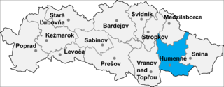
Rovné is a village and municipality in Humenné District in the Prešov Region of north-east Slovakia.
Gmina Konopiska is a rural gmina in Częstochowa County, Silesian Voivodeship, in southern Poland. Its seat is the village of Konopiska, which lies approximately 12 kilometres (7 mi) south-west of Częstochowa and 53 km (33 mi) north of the regional capital Katowice.
Jasiewo is a village in the administrative district of Gmina Gruta, within Grudziądz County, Kuyavian-Pomeranian Voivodeship, in north-central Poland.
Stojeszyn-Kolonia is a village in the administrative district of Gmina Modliborzyce, within Janów Lubelski County, Lublin Voivodeship, in eastern Poland.
Płonka-Kozły is a village in the administrative district of Gmina Łapy, within Białystok County, Podlaskie Voivodeship, in north-eastern Poland.
Piaski is a village in the administrative district of Gmina Tykocin, within Białystok County, Podlaskie Voivodeship, in north-eastern Poland.
Śniadowo-Stara Stacja is a village in the administrative district of Gmina Śniadowo, within Łomża County, Podlaskie Voivodeship, in north-eastern Poland.
Świerże-Kiełcze is a village in the administrative district of Gmina Zaręby Kościelne, within Ostrów Mazowiecka County, Masovian Voivodeship, in east-central Poland.

Kierzkowice is a village in the administrative district of Gmina Chodzież, within Chodzież County, Greater Poland Voivodeship, in west-central Poland. It lies approximately 4 kilometres (2 mi) north-west of Chodzież and 68 km (42 mi) north of the regional capital Poznań.
Słomki is a village in the administrative district of Gmina Chodzież, within Chodzież County, Greater Poland Voivodeship, in west-central Poland. It lies approximately 9 kilometres (6 mi) east of Chodzież and 68 km (42 mi) north of the regional capital Poznań.
Babi Dwór is a settlement in the administrative district of Gmina Okonek, within Złotów County, Greater Poland Voivodeship, in west-central Poland.
Dolinka is a settlement in the administrative district of Gmina Przechlewo, within Człuchów County, Pomeranian Voivodeship, in northern Poland. It lies approximately 4 kilometres (2 mi) west of Przechlewo, 19 km (12 mi) north-west of Człuchów, and 113 km (70 mi) south-west of the regional capital Gdańsk.
Rozogi is a village in the administrative district of Gmina Sorkwity, within Mrągowo County, Warmian-Masurian Voivodeship, in northern Poland. It lies approximately 6 kilometres (4 mi) south of Sorkwity, 15 km (9 mi) south-west of Mrągowo, and 42 km (26 mi) east of the regional capital Olsztyn.
Lipowo is a village in the administrative district of Gmina Biskupiec, within Olsztyn County, Warmian-Masurian Voivodeship, in northern Poland. It lies approximately 5 kilometres (3 mi) east of Biskupiec and 35 km (22 mi) east of the regional capital Olsztyn.
Brzozowo is a village in the administrative district of Gmina Przybiernów, within Goleniów County, West Pomeranian Voivodeship, in north-western Poland. It lies approximately 5 kilometres (3 mi) north of Przybiernów, 28 km (17 mi) north of Goleniów, and 44 km (27 mi) north of the regional capital Szczecin.
Kartlewo is a village in the administrative district of Gmina Przybiernów, within Goleniów County, West Pomeranian Voivodeship, in north-western Poland. It lies approximately 5 kilometres (3 mi) north of Przybiernów, 27 km (17 mi) north of Goleniów, and 44 km (27 mi) north of the regional capital Szczecin.

Brosseau is a hamlet in central Alberta, Canada within the County of Two Hills No. 21. It is located on the north bank of the North Saskatchewan River along the Highway 29 / Highway 36 concurrency, 50 km (31 mi) southwest of St. Paul. The hamlet of Duvernay is located immediately across the river along the south bank.

Kočarim is a village in the municipality of Višegrad, Bosnia and Herzegovina.

The Fugang Fishery Harbor is a harbor in Taitung City, Taitung County, Taiwan.
Varick is a hamlet in the Town of Varick, Seneca County, New York, United States near the former Seneca Army Depot along Reeder Creek. It is located 9 miles southeast of the City of Geneva, at an elevation of 604 feet. The primary intersection in the hamlet is at N.Y. Route 96A and Yale Farm Road.


