
The Catskill Park is in the Catskill Mountains in New York in the United States. It consists of 700,000 acres of land inside a Blue Line in four counties: Delaware, Greene, Sullivan, and Ulster. As of 2005, 287,500 acres (116,300 ha) or 41 percent of the land within, is owned by the state as part of the Forest Preserve; it is managed by the Department of Environmental Conservation (DEC). Another 5% is owned by New York City to protect four of the city's reservoirs in the region that lie partially within the park and their respective watersheds.

The protected areas of the United States are managed by an array of different federal, state, tribal and local level authorities and receive widely varying levels of protection. Some areas are managed as wilderness, while others are operated with acceptable commercial exploitation. As of 2015, the 25,800 protected areas covered 1,294,476 km2 (499,800 sq mi), or 14 percent of the land area of the United States. This is also one-tenth of the protected land area of the world. The U.S. also had a total of 787 National Marine Protected Areas, covering an additional 1,271,408 km2 (490,893 sq mi), or 12 percent of the total marine area of the United States.
The Nature Coast is an informal, unofficial region of the U.S. state of Florida. The broadest definition of the Nature Coast includes the eight counties that abut the Gulf of Mexico along the Big Bend Coast defined by geologists: from west to east, Wakulla, Jefferson, Taylor, Dixie, Levy, Citrus, Hernando, and Pasco counties.
The protected areas of Michigan come in an array of different types and levels of protection. Michigan has five units of the National Park Service system. There are 14 federal wilderness areas; the majority of these are also tribal-designated wildernesses. It has one of the largest state forest systems as well having four national forests. The state maintains a large state park system and there are also regional parks, and county, township and city parks. Still other parks on land and in the Great Lakes are maintained by other governmental bodies. Private protected areas also exist in the state, mainly lands owned by land conservancies.

Pisgah National Forest is a National Forest in the Appalachian Mountains of western North Carolina. It is administered by the United States Forest Service, part of the United States Department of Agriculture. The Pisgah National Forest is completely contained within the state of North Carolina. The forest is managed together with the other three North Carolina National Forests from common headquarters in Asheville, North Carolina. There are local ranger district offices located in Pisgah Forest, Mars Hill, and Nebo.

New York's Forest Preserve, comprises almost all the lands owned by the state of New York within the Adirondack and Catskill parks. It is managed by the state Department of Environmental Conservation (DEC). Of the 4.7 million acres(19,000 km2) of land in the state maintained by DEC, nearly 3 million (12,000 km2) are considered to be Forest Preserve.

The Mountains-to-Sea State Trail (MST) is a long-distance trail for hiking and backpacking, that traverses North Carolina from the Great Smoky Mountains to the Outer Banks. The trail's western endpoint is at Clingman's Dome, where it connects to the Appalachian Trail in the Great Smoky Mountains National Park. Its eastern endpoint is in Jockey's Ridge State Park on the tallest sand dune on the east coast. The trail is envisioned as a scenic backbone of an interconnected trail system spanning the state. As such, the trail's route attempts to connect as many trail systems and natural scenic areas as practicable. A little over half of the trail is complete in multiple segments across the state.

The Slide Mountain Wilderness Area is, at 47,500 acres (19,200 ha), the largest tract of state-owned Forest Preserve in New York's Catskill Park, and the largest area under any kind of wilderness area protection between the Adirondacks and the southern Appalachians. It is located in the towns of Shandaken, Denning and Olive in Ulster County.

The Withlacoochee River originates in central Florida's Green Swamp, east of Polk City. It flows west, then north, and then turns northwest and finally west again before it empties into the Gulf of Mexico near Yankeetown. The river is 141 miles (227 km) long and has a drainage basin of 1,170 square miles (3,000 km2). It is believed to have been named after the Withlacoochee River to the north.
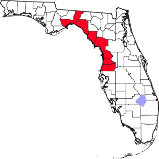
The Southwest Florida Water Management District, is one of five regional agencies directed by Florida state law to protect and preserve water resources. Established in 1961 the agency operates and maintains several large properties and flood protection projects, sometimes with other agencies. The District's responsibilities have expanded to include managing water supply and protecting water quality and the natural systems — rivers, lakes, wetlands and associated uplands.
In 1999, the Guana Tolomato Matanzas National Estuarine Research Reserve was designated in St. Johns and Flagler counties, Florida as a part of the National Oceanic and Atmospheric Administration (NOAA) National Estuarine Research Reserve (NERR) system. The GTM Research Reserve represents the east Florida sub-region of the Carolinian bioregion. It is one of 29 NERRs in 23 states and one territory. GTM is one of three NERRs in Florida, and is administered on behalf of the state by the Florida Department of Environmental Protection's Florida Coastal Office as part of a network that includes forty-one aquatic preserves, three NERRs, a National Marine Sanctuary, the Coral Reef Conservation Program and the Florida Oceans and Coastal Council.

According to the California Protected Areas Database (CPAD), in the state of California, United States, there are over 14,000 inventoried protected areas administered by public agencies and non-profits. In addition, there are private conservation areas and other easements. They include almost one-third of California's scenic coastline, including coastal wetlands, estuaries, beaches, and dune systems. The California State Parks system alone has 270 units and covers 1.3 million acres (5,300 km2), with over 280 miles (450 km) of coastline, 625 miles (1,006 km) of lake and river frontage, nearly 18,000 campsites, and 3,000 miles (5,000 km) of hiking, biking, and equestrian trails.

Hal Scott Regional Preserve and Park is a 9,515-acre (38.51 km2) nature preserve located along the banks of the Econlockhatchee River in east Orange County, Florida, United States. The Preserve is bordered by the Econlockhatchee on the West and Wedgefield, Florida on the East. It is managed by the St. Johns River Water Management District and Orange County Parks and Recreation. Recreational amenities include camping, hiking, horseback riding, mountain biking, fishing, and wildlife viewing.
Crews Lake Wilderness Park is located off Shady Hills Road in Pasco County, Florida. The park includes hiking trails, a short paved bike trail, playground, wooden tower, athletic fields, and the 7 1⁄2 in gauge Central Pasco & Gulf Railroad. Rides on the miniature railroad are offered the second Saturday of every month. The lake is the source for the Pithlachascotee River. Jumping Gully Preserve is adjacent to the park.
Conner Preserve is a natural area in central Pasco County, Florida preserved for water management since 2003. The landscape includes steep sandhill ridges, marshes, cypress sloughs and pine flatwoods and is "part of a wildlife habitat corridor envisioned by Pasco County and the Southwest Florida Water Management District that will eventually connect the Starkey Wilderness Preserve to the Cypress Creek Preserve, making a continuous corridor of several thousands of acres in this region." It is used recreationally for bicycling, horseback riding, hiking, camping, and model airplane flying. The park is located at 22500 on State Road 52 in Land O' Lakes, Florida. It is 2,980 acres (12.1 km2) and open from sunrise to sunset.
The Green Swamp is a swamp in Florida. It lies west of Highway 27 and east of Interstate 75 in Polk, Lake, Sumter, Hernando and Pasco Counties. The headwaters of the Peace River, Withlacoochee River, Ocklawaha River, and Hillsborough River are located here.
Green Swamp Wilderness Preserve is a 110,000 acre preserve in the four-corner area of Lake County, Pasco County, Polk County and Sumter County, east of Dade City, Florida. It includes a 36-mile section of the Withlacoochee River and offers hiking trails. It is managed by the Southwest Florida Water Management District. It includes various habitats and is home to a wide array of wildlife. The preserve is divided into five areas: 5,067 acre Colt Creek State Park, the 51,149 acre East Tract; the 11,052 acre Hampton Tract; the 4,446 acre Little Withlacoochee Tract; and the 37,350 acre West Tract.

The Balm-Boyette Scrub Nature Preserve is a 5,723-acre (2,316 ha) preserve located in Hillsborough County, Florida. It was purchased through joint funding from the County's Environmental Lands Acquisition and Protection Program (ELAPP) and the State of Florida's Conservation and Recreation Lands (CARL) Program. While it consists largely of abandoned phosphate pits, it has a large area of undisturbed scrub habitat. Natural habitats within the site include sand pine scrub, xeric oak scrub, pine flatwoods, hardwood hammock, wet prairie, freshwater marsh, cypress swamp, and hardwood swamp. During the 1960s the land was pitted with phosphate mines. The natural waterflow had been altered from its original state into a series of stagnant pools. In 2016, a project was undertaken under the umbrella of Swiftmud's Surface Water Improvement and Management, or SWIM, program. The project will create a "habitat mosaic" with habitat for wading birds as well as upland creatures.
The SouthWest Association of Mountain Bike Pedalers (SWAMP) club is an association of mountain bikers that creates, and maintains mountain biking trails in Florida. The organization has built and maintains trails in several parks, including Alafia River State Park, Balm-Boyette Scrub Nature Preserve, Croom Trail, Santos Trail and the Jay B. Starkey Wilderness Park Trail in Pasco County. Many of the trails are built on the remains of abandoned phosphate mines, which allows for a great variation in difficulty from easy to extremely advanced.
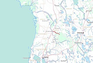
The Little Withlacoochee River is a 16-mile long river with its headwaters starting in the Richloam Wildlife Management Area in Sumter County, Florida. The Little Withlacoochee River ends near River Junction Campground just east of Silver Lake in the Croom Wildlife Management Area. It makes up a portion of the Hernando-Sumter County border. Its drainage basin covers 145 mi² (376 km²) of Hernando County and Sumter County.
