Related Research Articles

Wyoming County is a county located in the U.S. state of Pennsylvania. As of the 2010 census, the population was 28,276. Its county seat is Tunkhannock. It was created in 1842 from part of Luzerne County.

Oktibbeha County is a county located in the east central portion of the U.S. state of Mississippi. As of the 2010 census the population was 47,671. The county seat is Starkville. The county's name is derived from a local Native American word meaning either "bloody water" or "icy creek". The Choctaw had long occupied much of this territory prior to European exploration and United States acquisition.

Nicholson is a borough in Wyoming County, Pennsylvania, United States. The population was 767 at the 2010 census.

Tunkhannock is a borough in Wyoming County, Pennsylvania, 31 miles (50 km) northwest of Wilkes-Barre. In the past, lumbering was carried on extensively. Today, many residents are employed by the Procter & Gamble plant in nearby Washington Township. As of the 2010 census, the borough population was 1,836. It is the county seat of Wyoming County. Tunkhannock is in the Scranton–Wilkes-Barre–Hazleton, PA Metropolitan Statistical Area.
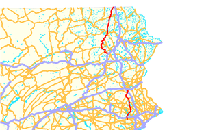
Pennsylvania Route 29 is a 118-mile-long (190 km) north–south state highway that runs through most of eastern Pennsylvania. The route currently exists in two segments, a southern segment and a northern segment. The southern segment runs from U.S. Route 30 near Malvern north to Interstate 78 (I-78)/PA 309 near Allentown. The northern segment runs from I-81 in Ashley north to the New York-Pennsylvania border near Brookdale, where the road becomes New York State Route 7.

Tunkhannock Creek is a 42.3-mile-long (68.1 km) tributary of the Susquehanna River in northeastern Pennsylvania, United States.

Martins Creek is a 20.4-mile-long (32.8 km) tributary of Tunkhannock Creek in northeastern Pennsylvania in the United States.

Pennsylvania Route 92 is a 66-mile-long (106 km) north–south state highway located in northeast Pennsylvania. The southern terminus of the route is at U.S. Route 11 in West Pittston. The northern terminus is at the New York-Pennsylvania border in Oakland Township, where PA 92 continues northward as New York State Route 79 (NY 79).
Tunkhannock Creek is a 19.2-mile-long (30.9 km) tributary of Tobyhanna Creek in the Poconos of eastern Pennsylvania in the United States.
Salt Lick Creek is an 11.1-mile-long (17.9 km) tributary of the Susquehanna River in Susquehanna County, Pennsylvania in the United States.

Osterhout Mountain is a summit located in Wyoming County, Pennsylvania. Osterhout is located on the east bank of the Susquehanna River opposite its sister peak Miller Mountain. The mountain has communication towers on its summit and rises over the town of Tunkhannock Pennsylvania.

Starkville is hamlet located west of Fort Plain on NY 80, in the eastern part of the town of Stark in southern Herkimer County, New York, United States. Established in the late 18th century, at one time the hamlet had a post office, three churches, two hotels, a store, several mills, a cheese factory, a number of shops and about 40 homes. In 2014, many of these structures are gone, but several remain, including an old carriage house factory and two churches on Rt. 80, one of which is in private ownership as an art studio.

Oxbow Creek is a tributary of Tunkhannock Creek in Wyoming County, Pennsylvania, in the United States. It is approximately 2.5 miles (4.0 km) long and flows through Lemon Township. The watershed of the creek has an area of 8.56 square miles (22.2 km2). The creek has two named tributarie: Horton Creek and Oxbow Inlet. It is not designated as an impaired waterbody. The surficial geology in its vicinity mostly consists of Wisconsinan Till, alluvium, Wisconsinan Ice-Contact Stratified Drift, and bedrock.
Horton Creek is a tributary of Oxbow Creek in Susquehanna County and Wyoming County, in Pennsylvania, in the United States. It is approximately 3.3 miles (5.3 km) long and flows through Springville Township in Susquehanna County and Lemon Township and Nicholson Township in Wyoming County. The watershed of the creek has an area of 3.60 square miles (9.3 km2). The creek is not designated as an impaired waterbody. The surficial geology in its vicinity mainly consists of alluvium, Wisconsinan Till, Wisconsinan Ice-Contact Stratified Drift, alluvial terrace, and wetlands.

Monroe Creek is a tributary of Tunkhannock Creek in Susquehanna County and Wyoming County, in Pennsylvania, in the United States. It is approximately 6.1 miles (9.8 km) long and flows through Springville Township in Susquehanna County and Nicholson Township in Wyoming County. The watershed of the creek has an area of 6.64 square miles (17.2 km2). The creek is not designated as an impaired waterbody. The surficial geology in its vicinity consists mostly of alluvium, Wisconsinan Till, and other things. Its watershed is designated as a Coldwater Fishery and a Migratory Fishery.

Field Brook is a tributary of Tunkhannock Creek in Susquehanna County and Wyoming County, in Pennsylvania, in the United States. It is approximately 5.8 miles (9.3 km) long and flows through Lathrop Township in Susquehanna County and Nicholson Township in Wyoming County. The watershed of the stream has an area of 7.41 square miles (19.2 km2). The stream has one named tributary, which is known as East Branch Field Brook. The surficial geology in the vicinity of Field Brook consists of alluvium, Wisconsinan Till, alluvial terrace, alluvial fan, bedrock, wetlands, and a lake. The watershed of the stream is designated as a Coldwater Fishery and a Migratory Fishery.

Horton Creek is a tributary of Tunkhannock Creek in Susquehanna County and Wyoming County, in Pennsylvania, in the United States. It is approximately 11 miles (18 km) long and flows through Brooklyn Township and Lathrop Township in Susquehanna County and Nicholson Township and Nicholson in Wyoming County. The watershed of the creek has an area of 16.9 square miles (44 km2). The creek is not designated as an impaired waterbody and has no named tributaries. The topography of the creek's watershed has been described as "rough and hilly" and its channel is sinuous.
Utley Brook is a tributary of Tunkhannock Creek in Susquehanna County and Wyoming County, in Pennsylvania, in the United States. It is approximately 4.5 miles (7.2 km) long and flows through Lenox Township in Susquehanna County and Nicholson Township in Wyoming County. The stream is in the United States Geological Survey quadrangles of Hop Bottom and Lenoxville. The surficial geology in its vicinity consists of Wisconsinan Till, alluvium, bedrock, wetlands, and lakes. The creek is a Coldwater Fishery and a Migratory Fishery. It has one named tributary, which is known as Willow Brook.
Nine Partners Creek is a tributary of Tunkhannock Creek in Susquehanna County, Pennsylvania, in the United States. It is approximately 10 miles (16 km) long and flows through New Milford Township, Harford Township, and Lenox Township. The watershed of the creek has an area of 38.6 square miles (100 km2). The creek has two named tributaries: Butler Creek and Leslie Creek. The surficial geology in the vicinity of Nine Partners Creek includes Wisconsinan Till, alluvium, bedrock, alluvial fan, and wetlands. The creek's drainage basin is designated as a Coldwater Fishery and a Migratory Fishery.
References
- ↑ "GNIS". Geographic Names Information System. US Geological Survey. Retrieved 16 November 2017.
- ↑ Josh Mrozinski (August 23, 2006), "$200k slated for stream bank work", Wyoming County Press Examiner, retrieved November 16, 2017
Coordinates: 41°36′21″N75°50′04″W / 41.60583°N 75.83444°W
| | This Wyoming County, Pennsylvania state location article is a stub. You can help Wikipedia by expanding it. |