Starr Hill, Juneau

Last updated

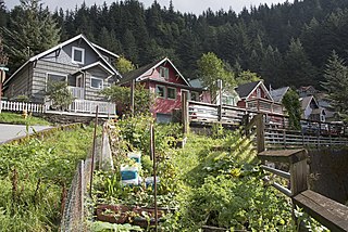
Starr Hill is a populated place in Juneau, Alaska, United States. It is named for Frank Starr (1849-1898), a soldier from Maine who arrived shortly after the discovery of the Juneau gold fields in 1880, staked some claims but mainly found work in construction. Starr also staked land on the hill near the road leading to the Silver Bow Basin gold fields. The Hill saw significant development beginning in 1913 when Conrad Fries (d. 1922) built six miners’ cabins on the 500 block of Kennedy Street, buildings which are now listed on the National Register of Historic Places. A few years later Juneau businessman Bernard (B.M.) Behrends (b. 1862) built five smaller cabins on the 400 block of Kennedy. Starr Hill now includes several dozen private homes which overlook upper Juneau and the Alaska State Capitol, and a trailhead to the Mount Roberts Trail. [1]

Juneau, Alaska State capital city and borough in Alaska, United States

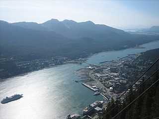
The City and Borough of Juneau, commonly known as Juneau, is the capital city of Alaska. It is a unified municipality on Gastineau Channel in the Alaskan panhandle, and it is the second largest city in the United States by area. Juneau has been the capital of Alaska since 1906, when the government of what was the District of Alaska was moved from Sitka as dictated by the U.S. Congress in 1900. The municipality unified on July 1, 1970, when the city of Juneau merged with the city of Douglas and the surrounding Greater Juneau Borough to form the current municipality, which is larger by area than both Rhode Island and Delaware.

Alaska State of the United States of America

Alaska is a U.S. state in the northwest extremity of North America, just across the Bering Strait from Asia. The Canadian province of British Columbia and territory of Yukon border the state to the east, its most extreme western part is Attu Island, and it has a maritime border with Russia to the west across the Bering Strait. To the north are the Chukchi and Beaufort seas—southern parts of the Arctic Ocean. The Pacific Ocean lies to the south and southwest. It is the largest state in the United States by area and the seventh largest subnational division in the world. In addition, it is the 3rd least populous and the most sparsely populated of the 50 United States; nevertheless, it is by far the most populous territory located mostly north of the 60th parallel in North America: its population—estimated at 738,432 by the United States Census Bureau in 2015— is more than quadruple the combined populations of Northern Canada and Greenland. Approximately half of Alaska's residents live within the Anchorage metropolitan area. Alaska's economy is dominated by the fishing, natural gas, and oil industries, resources which it has in abundance. Military bases and tourism are also a significant part of the economy.

United States federal republic in North America

The United States of America (USA), commonly known as the United States or America, is a country composed of 50 states, a federal district, five major self-governing territories, and various possessions. At 3.8 million square miles, the United States is the world's third or fourth largest country by total area and is slightly smaller than the entire continent of Europe's 3.9 million square miles. With a population of over 327 million people, the U.S. is the third most populous country. The capital is Washington, D.C., and the largest city by population is New York. Forty-eight states and the capital's federal district are contiguous in North America between Canada and Mexico. The State of Alaska is in the northwest corner of North America, bordered by Canada to the east and across the Bering Strait from Russia to the west. The State of Hawaii is an archipelago in the mid-Pacific Ocean. The U.S. territories are scattered about the Pacific Ocean and the Caribbean Sea, stretching across nine official time zones. The extremely diverse geography, climate, and wildlife of the United States make it one of the world's 17 megadiverse countries.

The name was published in 1957 by R. N. DeArmond and entered into the Geographic Names Information System on July 12, 2000. [2]

Robert Neil "Bob" DeArmond was an American historian who specialized in the history of Alaska, especially the Alaska Panhandle. Throughout the 1970s and 1980s, DeArmond wrote several historical columns for southeast Alaska publications; these included Days of Yore, Gastineau Bygones, and News of the Gold Camp. He lived in Sitka, Alaska, and continued to write until his death.

Geographic Names Information System geographical database

The Geographic Names Information System (GNIS) is a database that contains name and locative information about more than two million physical and cultural features located throughout the United States of America and its territories. It is a type of gazetteer. GNIS was developed by the United States Geological Survey in cooperation with the United States Board on Geographic Names (BGN) to promote the standardization of feature names.

Related Research Articles

Douglas Island A tidal island in Alaska, just west of downtown Juneau and east of Admiralty Island

Douglas Island is a tidal island in the U.S. state of Alaska, just west of downtown Juneau and east of Admiralty Island. It is separated from mainland Juneau by the Gastineau Channel.

The Juneau Empire is a newspaper in Juneau, Alaska, United States.

Mendenhall Valley, Juneau

The Mendenhall Valley is the drainage area of the Mendenhall River in the U.S. state of Alaska. The valley contains a series of neighborhoods, comprising the largest populated place within the corporate limits of the City and Borough of Juneau, Alaska's capital.

White Pass mountain pass

White Pass, also known as the Dead Horse Trail, is a mountain pass through the Boundary Ranges of the Coast Mountains on the border of the U.S. state of Alaska and the province of British Columbia, Canada. It leads from Skagway, Alaska, to the chain of lakes at the headwaters of the Yukon River, Crater Lake, Lake Lindeman, and Bennett Lake.

Admiralty Island island in the United States of America

Admiralty Island is an island in the Alexander Archipelago in Southeast Alaska, at 57°44′N134°20′W. It is 145 km (90 mi) long and 56 km (35 mi) wide with an area of 4,264.1 km2 (1,646.4 sq mi), making it the seventh largest island in the United States and the 132nd largest island in the world. It is one of the ABC islands of Alaska. The island is nearly cut in two by the Seymour Canal; to its east is the long, narrow Glass Peninsula. Most of Admiralty Island—more than 955,000 acres (3,860 km2)—is occupied by the Admiralty Island National Monument - a federally protected wilderness area administered by the Tongass National Forest. The Kootznoowoo Wilderness encompasses vast stands of old growth temperate rainforest. These forests provide some of the best habitat available to species such as brown bears, bald eagles, and Sitka black-tailed deer.

Mount Roberts Tramway aerial tramway

The Mount Roberts Tramway is an aerial tramway located just south of downtown Juneau in the U.S. state of Alaska. In operation since 1996, the tram makes a six-minute ascent of 3,819-foot (1,164 m) Mount Roberts from the cruise ship docks to a height of about 1,800 feet (550 m). A restaurant, theater, nature center and retail shops are located at the top of the tramway, as well as connections to trails leading both up and down the mountain. One trail up the mountain leads to a large cross erected by Roman Catholic Father Brown in the early 1900s.

Adair-Kennedy Memorial Park is a sports facility complex in Juneau, Alaska, and adjacent to Floyd Dryden Middle School. It was named after Richard James Adair and Jimmy Earl Kennedy, two Juneau Police Department officers who died in the line of duty on April 17, 1979.

Treadwell gold mine mine on Douglas Island, AK active 1881-1922

The Treadwell gold mine was on the south side of Douglas Island, .5-mile (0.80 km) east of downtown Douglas and southeast of downtown Juneau, owned and operated by John Treadwell. Composed of four sub-sites, Treadwell was in its time the largest hard rock gold mine in the world, employing over 2,000 people. Between 1881 and 1922, over 3 million troy ounces of gold were extracted. Not much remains today except for a few crumbling buildings and a "glory hole". Although John Treadwell had twelve years of experience in both placer and lode mines, he was a carpenter and builder by trade who had come to Alaska prior to the Klondike Gold Rush.

Quartz Gulch was a small gulch on the eastern side of Mount Roberts, about 2.5 miles (4 km) east of Juneau, Alaska. The gulch flowed into Silver Bow Basin. Richard Harris and Joe Juneau, with Chief Kowee, discovered gold in the gulch on October 3, 1880. Harris mined the gulch from 1880 to 1886, taking at least $75,000 in gold.

The gulch I named from the fact that it contained the most gold bearing quartz I had ever seen in one gulch.

<i>Rosalie</i> (steamship) 1893 teamboat

The steamboat Rosalie operated from 1893 to 1918 as part of the Puget Sound Mosquito Fleet, also operating out of Victoria, B.C. In 1898, Rosalie went north with many other Puget Sound steamboats to join the Klondike Gold Rush.

Lemon Creek is a neighborhood in Juneau, Alaska, United States. The name was entered into the Geographic Names Information System on January 1, 2000. It is 5 miles (8 km) northwest of downtown Juneau. It is the site of the Lemon Creek Correctional Center. The neighborhood is bisected by the namesake Lemon Creek, which provides runoff for local glaciers.

Lena Beach is a populated place in Juneau, Alaska, United States. The name was first published by the Bureau of the Census in 1940 and entered into the Geographic Names Information System on March 23, 2001. It is 14 miles (23 km) northwest of the city of Juneau.

Vanderbilt Hill, Juneau human settlement in United States of America

Vanderbilt Hill is a populated place in Juneau, Alaska, United States. Located on the eastern shore of Gastineau Channel, it is named for John W. Vanderbilt, a local businessman who lived in the area between 1906 and 1907.

West Juneau, Alaska human settlement in United States of America

West Juneau is a populated place in Juneau, Alaska, United States. It is located on Douglas Island 1.8 miles (2.9 km) northwest of Douglas. The name was first published by the United States Geological Survey in 1948 and entered into the Geographic Names Information System on March 31, 1981. Despite its location on Douglas Island, the neighborhood was juridically a part of the City of Juneau, rather than the City of Douglas, prior to municipal unification in 1970.

Kowee Creek

Kowee Creek is a river on Douglas Island in the City and Borough of Juneau, Alaska, United States. Its origin is southeast of Mount Troy and it flows north-northeast to Gastineau Channel near West Juneau; it is 0.5 miles (0.80 km) southwest of the city of Juneau. Kowee Creek is nearly 10 miles (16 km) long. It has a drainage basin of about 50 square miles (130 km2) and two transverse tributaries.

Elevenmile Creek is a river on Douglas Island in the City and Borough of Juneau (CBJ), Alaska, United States. Its origin is in hills to the southeast and it flows northwest to Fritz Cove, a part of Stephens Passage; it is 1.6 miles (2.6 km) southwest of Entrance Point and 8.6 miles (13.8 km) west of the city of Juneau.

Gold Creek (Juneau, Alaska)

Gold Creek is a waterway in the southeastern section of the U.S. state of Alaska. It is located in Silver Bow Basin at the edge of Juneau. In 1880, Chief Kowee revealed to prospectors Joe Juneau and Richard Harris the presence of gold in Gold Creek; the city of Juneau was founded in the same year. Named by miners, it was first published in 1883.

Fries Miners Cabins

The Fries Miners' Cabins are a group of six small houses located on the 500 block of Kennedy Street, in the Starr Hill neighborhood adjacent to downtown Juneau, Alaska. The six were built as essentially identical structures in 1913 to house miners working in the local gold mines. The houses are 1-1/2 story structures of wood frame construction, and are in the Craftsman style popular at the time. Of the more than 200 miner houses built during Juneau's gold boom, these are among the few that survive.

Amalga is a former gold-mining town outside of Juneau, Alaska. The area is now part of the Tongass National Forest. The Library of Congress has a photograph of Amalga by Winter & Pond in its collection. The area was once homesteaded and farmed. A horse tram brought goods delivered by steamship to the mine.

References

  1. Juneau's Historic Neighborhoods, Volume One Starr Hill, City and Borough of Juneau Community Development Department, 1986
  2. USGS GNIS Feature Detail Report: Starr Hill

Coordinates: 58°18′15″N134°24′15″W / 58.30417°N 134.40417°W / 58.30417; -134.40417

Geographic coordinate system Coordinate system

A geographic coordinate system is a coordinate system that enables every location on Earth to be specified by a set of numbers, letters or symbols. The coordinates are often chosen such that one of the numbers represents a vertical position and two or three of the numbers represent a horizontal position; alternatively, a geographic position may be expressed in a combined three-dimensional Cartesian vector. A common choice of coordinates is latitude, longitude and elevation. To specify a location on a plane requires a map projection.