Complexe Sportif d'El Alia is a multi-use stadium in Biskra, Algeria. It is currently used mostly for football matches and is the home ground of US Biskra. The stadium holds 30,000 people.
Illingworth St Mary's Cricket Club is a cricket club based in Illingworth, 3 miles (5 km) north of Halifax in West Yorkshire, England. They play in the Spenser Wilson Halifax Cricket League, as well as the Halifax League Sunday Section.

Rajbari Sadar is an Upazila of Rajbari District in the Division of Dhaka, Bangladesh.
Mohammadpur is a thana of Dhaka District in the division of Dhaka, Bangladesh. Although initially Mohammadpur had grown as a residential area subsequently commercial places also developed. Its post code of Mohammadpur is 1207.
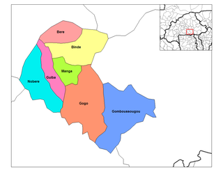
Binde is a department or commune of Zoundwéogo Province in central Burkina Faso.
Roszki-Chrzczony is a village in the administrative district of Gmina Sokoły, within Wysokie Mazowieckie County, Podlaskie Voivodeship, in north-eastern Poland.
Żukowo is a village in the administrative district of Gmina Bielsk, within Płock County, Masovian Voivodeship, in east-central Poland.

Kosewo is a village in the administrative district of Gmina Żuromin, within Żuromin County, Masovian Voivodeship, in east-central Poland. It lies approximately 6 kilometres (4 mi) east of Żuromin and 116 km (72 mi) north-west of Warsaw.
Daisyfield railway station was a railway station that served the Daisyfield area of Blackburn, Lancashire.
Fajhan Hilal Al-Mutairi Court is an indoor sporting arena located in Kuwait City, Kuwait. The capacity of the arena is 5,000 spectators. It hosts indoor sporting events such as basketball and hosts the home matches of Al Qadisiya Kuwait. It also hosted the FIBA Asia Champions Cup 2006 and FIBA Asia Champions Cup 2008 championships.

Nagaura Station is a railway station operated by Meitetsu's Tokoname Line located in Chita, Aichi Prefecture, Japan. It is located 18.7 rail kilometers from the terminus of the line at Jingū-mae Station.
Dar Sad District is a district of the Aden Governorate, Yemen. As of 2003, the district had a population of 79,712 inhabitants.

Seremuk River is a river in West Papua province, Indonesia.
Murrell's Row was a red-light district of Atlanta "starting at the juncture of Line, Decatur and Peachtree streets" (i.e. at today's Five Points "and running back towards Pryor on Decatur street". According to Archival Atlanta:
Named for the notorious Tennessee murderer, John A. Murrell, this section of town was a favorite hangout for thieves, gamblers, cutthroats, and prostitutes. Drunken brawls and cockfights were common and expected here. Before the Civil War, Murrell’s Row was the preferred meeting place for those who wanted to fight and concoct schemes. This notorious area north of Decatur Street between Peachtree and Pryor faded away shortly before the Civil War.
Elmrahu is an island belonging to the country of Estonia. The island is located west of the island Külalaid and is just off the coast of the much larger island Hiiumaa
Kösreli is a village in the District of Ceyhan, Adana Province, Turkey.

Jajpur Airstrip is a private airstrip located at Sukinda in the Jajpur district of Odisha. Nearest airport to this airstrip is Savitri Jindal Airport in Angul, Odisha.
Kanje is a village in Bijelo Polje Municipality, in northern Montenegro. According to the 2003 census, the village had a population of 389 people.
The Thunderbird Country Club is an 18-hole golf course designed by Lawrence Hughes in Rancho Mirage in California's Coachella Valley. It has hosted the Ryder Cup and the Palm Springs Golf Classic. Opened in 1951, the country club has been a favorite of many celebrities including Bing Crosby and Bob Hope as well as US Presidents Gerald Ford and Barack Obama

Fikri Alican was a Turkish scientist and physician with various contributions to medical science, ranging from organ transplantation to physiology.


