
The geography of France consists of a terrain that is mostly flat plains or gently rolling hills in the north and west and mountainous in the south and the east.

The Jubilee line is a London Underground line that runs between Stratford in east London and Stanmore in the suburban north-west, via the Docklands, South Bank and West End. Opened in 1979, it is the newest line on the network, although some sections of track date back to 1932 and some stations to 1879.

The Piccadilly line is a London Underground line that runs between Cockfosters in suburban north London and Acton Town in the west, where it divides into two branches: one of these runs to Heathrow Airport and the other to Uxbridge in northwest London, with some services terminating at Rayners Lane.
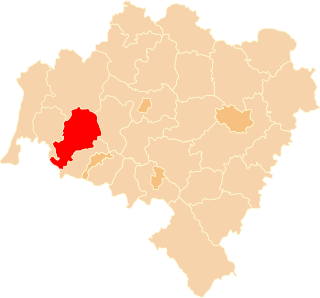
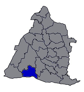
Lwówek Śląski County is a unit of territorial administration and local government (powiat) in Lower Silesian Voivodeship, south-western Poland. It came into being on January 1, 1999, as a result of the Polish local government reforms passed in 1998. The county covers an area of 709.9 square kilometres (274.1 sq mi). Its administrative seat is the town of Lwówek Śląski, and it also contains the towns of Gryfów Śląski, Mirsk, Wleń and Lubomierz.

A spiral is a technique employed by railways to ascend steep hills.
Articles in economics journals are usually classified according to the JEL classification codes, a system originated by the Journal of Economic Literature. The JEL is published quarterly by the American Economic Association (AEA) and contains survey articles and information on recently published books and dissertations. The AEA maintains EconLit, a searchable data base of citations for articles, books, reviews, dissertations, and working papers classified by JEL codes for the years from 1969. A recent addition to EconLit is indexing of economics-journal articles from 1886 to 1968 parallel to the print series Index of Economic Articles.

The European route E 22 is one of the longest European routes. It has a length of about 5,320 km (3,310 mi). Many of the E-roads have been extended into Asia since the year 2000; the E 22 was extended on 24 June 2002.
Shuswap Lake Marine Provincial Park is an 896-hectare provincial park in British Columbia, Canada, comprising 991 ha. The Park has a variety of amenities including boat launch ramps, picnic areas, and 27 campsites around the perimeter of Shuswap Lake. The lake's name and that of the surrounding Shuswap Country is from the Shuswap people (Secwepemc), the most northern of the Salishan speaking people.

Crystal Palace Ladies Football Club is a football club based in south-east London and playing in the FA Women's Championship. The club, known as the "Eagles", branches off from Crystal Palace F.C., the men's equivalent. The Ladies section offer female football from under-9s through to senior level, including an academy at The Priory School in Orpington.

Advanced Landing Grounds (ALGs) were temporary advance airfields constructed by the Allies during World War II during the liberation of Europe. They were built in the UK prior to the invasion and thereafter in northwest Europe from 6 June 1944 to V-E Day, 7 May 1945.
"Chanson d'automne" is a poem by Paul Verlaine, one of the best known in the French language. It is included in Verlaine's first collection, Poèmes saturniens, published in 1866. The poem forms part of the "Paysages tristes" section of the collection.

The 1981 Open Championship was a men's major golf championship and the 110th Open Championship, held from 16–19 July at Royal St George's Golf Club in Sandwich, England. Bill Rogers won his only major championship, four strokes ahead of runner-up Bernhard Langer. The Open returned to Royal St. George's for the first time since 1949, making it a new venue for all; no former champions finished in the top ten.

Lućmierz is a settlement in the administrative district of Gmina Zgierz, within Zgierz County, Łódź Voivodeship, in central Poland. It lies approximately 7 kilometres (4 mi) north of Zgierz and 15 km (9 mi) north of the regional capital Łódź.

Amchitka Air Force Base is an abandoned Air Force Base located on Amchitka, in the Rat Islands group of the Aleutian Islands in southwest Alaska.

The 12th European Cross Country Championships were held at Tilburg in Netherlands on 11 December 2005. Serhiy Lebid won the men's competition for the sixth time and Lornah Kiplagat won the women's race.
Zhutang Township is a rural township in Changhua County, Taiwan. It has a population total of 15,863 and an area of 42.1662 square kilometres.
Bardhamanbhukti was an ancient and medieval region/ territory spread across what are now Purba Bardhaman, Paschim Bardhaman and Bankura districts in the Indian state of West Bengal.

Down Bank is a 5.9-hectare (15-acre) biological Site of Special Scientific Interest south-west of Canterbury in Kent.


