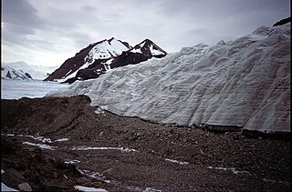
The Ohio Range is a range in the Transantarctic Mountains of Antarctica. It is about 30 nautical miles long and 10 nautical miles wide, extending west-southwest – east-northeast from Eldridge Peak to Mirsky Ledge. The range forms the northeast end of the Horlick Mountains and consists primarily of a large snow-topped plateau with steep northern cliffs and several flat-topped ridges and mountains. The highest point, 2,990 metres (9,810 ft), is the summit of Mount Schopf.
Kohler Range is a mountain range in Marie Byrd Land, Antarctica. The range is about 40 nautical miles long and stands between the base of Martin Peninsula and Smith Glacier. The range consists of two ice-covered plateaus punctuated by several rock peaks and bluffs. The plateaus are oriented East-West and are separated by the Kohler Glacier, a distributary which flows north from Smith Glacier.
Mikkelsen Bay is a bay, 15 nautical miles wide at its mouth and indenting 10 nautical miles, entered between Bertrand Ice Piedmont and Cape Berteaux along the west coast of Graham Land, Antarctica.
Northeast Glacier is a steep, heavily crevassed glacier, 13 nautical miles long and 5 nautical miles wide at its mouth, which flows from McLeod Hill westward and then south-westwards into Marguerite Bay between the Debenham Islands and Roman Four Promontory, on the west coast of Graham Land, Antarctica.
The Scott Mountains are a large number of isolated peaks lying south of Amundsen Bay in Enderby Land of East Antarctica, Antarctica. Discovered on 13 January 1930 by the British Australian New Zealand Antarctic Research Expedition (BANZARE) under Sir Douglas Mawson. He named the feature Scott Range after Captain Robert Falcon Scott, Royal Navy. The term mountains is considered more appropriate because of the isolation of its individual features.
The Hays Mountains are a large group of mountains and peaks of the Queen Maud Mountains of Antarctica, surmounting the divide between the lower portions of Amundsen Glacier and Scott Glacier and extending from the vicinity of Mount Thorne on the northwest to Mount Dietz on the southeast.

Shoesmith Glacier is the largest glacier on Horseshoe Island, flowing westward into both Lystad Bay and Gaul Cove. Named by United Kingdom Antarctic Place-Names Committee (UK-APC) in 1958 in association with Horseshoe Island.
The Mariner Glacier is a major glacier over 60 nautical miles long, descending southeast from the plateau of Victoria Land, Antarctica, between Mountaineer Range and Malta Plateau, and terminating at Lady Newnes Bay, Ross Sea, where it forms the floating Mariner Glacier Tongue.
Simpson Glacier is a glacier, 6 nautical miles, in the Admiralty Mountains, Antarctica. It flows northward to the coast between Nelson Cliff and Mount Cherry-Garrard where it forms the Simpson Glacier Tongue.
The Latady Mountains are a group of mountains rising west of Gardner Inlet and between Wetmore Glacier and Ketchum Glacier, in southeastern Palmer Land, Antarctica.
Black Pass is a pass trending northeast–southwest, 3 nautical miles (6 km) west of Mount Arronax, Pourquoi Pas Island, in northeast Marguerite Bay. It was named by the UK Antarctic Place-Names Committee after Stanley E. Black (1933–58), a Falkland Islands Dependencies Survey meteorological assistant on Signy Island, 1957–58, and on Horseshoe Island, 1958, who, with D. Statham and G. Stride, was lost between the Dion Islands and Horseshoe Island in May 1958, in a breakup of the sea ice.
Cugnot Ice Piedmont is an ice piedmont in Trinity Peninsula, Antarctica. It is about 15 nautical miles long and between 3 and 6 nautical miles wide, extending from Russell East Glacier to Eyrie Bay and bounded on the landward side by Louis Philippe Plateau.
Stride Peak is a peak rising to 675 m at the head of Dalgliesh Bay, Pourquoi Pas Island, in Marguerite Bay. Named by United Kingdom Antarctic Place-Names Committee (UK-APC) in 1979 after Geoffrey A. Stride (1927–58), Falkland Islands Dependencies Survey (FIDS) diesel mechanic, Horseshoe Island, 1958, who, with S.E. Black and D. Statham, was lost between Dion Islands and Horseshoe Island in May 1958, in a breakup of the sea ice.
Trifid Peak is a peak at the head of Shoesmith Glacier in western Horseshoe Island. Named by United Kingdom Antarctic Place-Names Committee (UK-APC) in 1958. The name is descriptive of this three-sided matterhorn-type peak.

Point Martin is a point on the east side of Mossman Peninsula, 1.5 km (0.93 mi) north-west of Cape Murdoch, on the south coast of Laurie Island in the South Orkney Islands of Antarctica. It was charted in 1903 by the Scottish National Antarctic Expedition under Bruce, who named it for J. Martin, an able seaman on the expedition ship Scotia.
Matthews Peak is a prominent peak, rising to 1,100 metres (3,600 ft) northwest of Statham Peak in the southwest part of Perplex Ridge, Pourquoi Pas Island, in Marguerite Bay, Antarctica. It was named by the UK Antarctic Place-Names Committee in 1979 after David W. Matthews, a British Antarctic Survey geologist on Stonington Island, 1965–67, who worked in the area.
The Mackin Table is an ice-topped, wedge-shaped plateau, about 20 nautical miles long, standing just north of Patuxent Ice Stream in the Patuxent Range of the Pensacola Mountains, Antarctica.
Hoskins Peak is a peak 3 nautical miles (6 km) west of Contact Peak in southern Pourquoi Pas Island, Graham Land, Antarctica. It was mapped by the Falkland Islands Dependencies Survey (FIDS) from surveys, 1956–59, and named by the UK Antarctic Place-Names Committee for Arthur K. Hoskins, a FIDS geologist at Stonington Island in 1958 and Horseshoe Island in 1959.
![]() This article incorporates public domain material from "Statham Peak". Geographic Names Information System . United States Geological Survey.
This article incorporates public domain material from "Statham Peak". Geographic Names Information System . United States Geological Survey. 
