
Sandnes (help·info) is a city and municipality in Rogaland county, Norway. It is the 8th largest city in Norway and it lies immediately south of the city of Stavanger, the 4th largest city in Norway. Together, the Stavanger/Sandnes area is the 3rd largest urban area in Norway.

Sveio is a municipality in Hordaland county, Norway. Sveio is a border district that is sometimes considered to be located in the traditional district of Haugalandet since it is located on the Haugalandet peninsula, but it is also considered to be in the traditional district of Sunnhordland since it is located in southern Hordaland county. The administrative centre of the municipality is the village of Sveio. Other villages in the municipality include Auklandshamn, Førde, Våga, and Valevåg.

Bindal is a municipality in the Helgeland region in the extreme southwest part of Nordland county, Norway. The administrative centre is the village of Terråk. Other villages include Bindalseidet, Holm, Vassås, Horsfjord and Åbygda.
Bø is a municipality in Nordland county, Norway. It is part of the Vesterålen region. The administrative centre of the municipality is the village of Straume. Other villages in the municipality include Auvåg, the village of Bø, Eidet, Guvåg, Hovden, Klakksjorda, Malnes, Nykvåg, Utskor, and Vågen. The Litløy Lighthouse is located on the tiny island of Litløya off the coast of Bø.

European highway E 134 is a European highway that crosses Norway starting near the city of Haugesund on the west coast, heading over Haukeli, passing the city of Drammen, and ending in the municipality of Frogn near the national capital of Oslo.

Våvatnet is a lake on the border of the municipalities of Snillfjord and Orkdal in Trøndelag county, Norway. The lake was dammed in 1910 and is used as the main reservoir for the municipality of Orkdal. The water flows into the lake Songsjøen and then into the lake Gagnåsvatnet.
Sørungen is a lake in the municipality of Selbu in Trøndelag county, Norway. The 7.24-square-kilometre (2.80 sq mi) lake is located about 8 kilometres (5.0 mi) south of the village of Vikvarvet, about 18 kilometres (11 mi) west of the village of Flora, and about 10 kilometres (6.2 mi) northeast of the lake Samsjøen in the neighboring municipality of Midtre Gauldal.

Bru is a former municipality in Sogn og Fjordane county, Norway. It is part of the present-day municipality of Flora in the traditional district of Sunnfjord. The administrative center of Bru was the village of Stavang. The municipality existed from 1923 until 1964 and it was made up of parts of the mainland along with several islands including Svanøya, Askrova, and Stavøya. It also included the Solheimsdalen valley, east of the village of Norddalsfjord.

Kinn is a former municipality in the Sunnfjord district of Sogn og Fjordane county, Norway. The parish of Kinn has existed for centuries and in 1838, the large parish was established as a municipality that existed from then until 1964. The municipality was centered at the island of Kinn where the main Kinn Church is located. The municipality encompassed all of the present-day municipality of Flora as well as parts of Askvoll and the southwestern part of Bremanger. Upon its dissolution in 1964, it covered 159 square kilometres (61 sq mi).

Breimsvatn or Breimsvatnet is a lake in the municipalities of Gloppen and Jølster in Sogn og Fjordane county, Norway. At 22.52 square kilometres (8.70 sq mi), it is the largest lake in Gloppen. The European route E39 highway runs along the north end of the lake, connecting the two nearby areas of Sandane and Byrkjelo. On the shores of the 17-kilometre (11 mi) long lake lie several villages including Re and Kandal. The lake flows into the Gloppenelva river which flows into the Gloppefjorden, an arm of the Nordfjorden. Historically, the area surrounding the lake was part of the municipality of Breim, which existed from 1886 until 1964.

Straumsfjorden or Straumfjorden is a lake that is located along the border of the municipalities of Bygland and Valle in Aust-Agder county, Norway. The lake has a dam on the south end which discharges into the Hjellevatn lake and eventually travels to the lake Topsæ and the Tovdalselva river drainage basin. The lake sits in the southeastern part of the municipality, about 11 kilometres (6.8 mi) southeast of the village of Rysstad and about 10 kilometres (6.2 mi) northeast of Besteland.
Nelaug is a lake in the municipalities of Froland and Åmli in Aust-Agder county, Norway. The 10 kilometres (6.2 mi) lake is formed by a dam which regulates a hydroelectric power plant on the Nidelva river. The village of Nelaug is located near the dam in Froland municipality. The lake is located about 11 kilometres (6.8 mi) south of the village of Åmli, about 15 kilometres (9.3 mi) southeast of the village of Dølemo, and about 20 kilometres (12 mi) north of Blakstad.

Førde Fjord is a fjord in Sogn og Fjordane county, Norway. It is the longest of all the fjords in the traditional district of Sunnfjord. Førdefjorden passes through the municipalities of Førde, Naustdal, Askvoll, and Flora. The fjord begins at the town of Førde, at the estuary of the river Jølstra, which comes from the lake Jølstravatn. The island of Svanøya lies just outside the mouth of Førdefjorden. There are roads along the shoreline on both the north and south sides of the fjord, and the European route E39 highway runs past the town of Førde, near Førdefjorden.
Einar Magnus Henriksson Stavang was a Norwegian lawyer and politician for the Labour Party.

Svanøy is an island in the municipality of Flora in Sogn og Fjordane county, Norway. The island is located in the Sunnfjord district of the county. The island lies just to the west of the mainland, in the mouth of the Førdefjorden. The Brufjorden runs along the north and east sides of the island and the Stavfjorden runs along the south side of the island. The island of Askrova lies about 4 kilometres (2.5 mi) northwest of Svanøy. The 10-square-kilometre (3.9 sq mi) island of Svanøy is heavily forested with lots of hills and small mountains. On Svanøy, there are plants and trees that usually are not found on the west coast of Norway, such as holly. The 235-metre (771 ft) tall mountain Vågsfjellet is the highest mountain on the island. The boat to Florø runs several times every day from Svanøybukt.
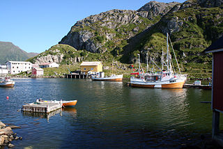
Stavang Church is a parish church in Flora Municipality in Sogn og Fjordane county, Norway. It is located in the village of Stavang. The church is part of the Bru parish in the Sunnfjord deanery in the Diocese of Bjørgvin. The whitewashed brick church was built in 1957 by the architect Ole Halvorsen. The church, with a seating capacity of 312, was consecrated on 16 June 1957, by Bishop Ragnvald Indrebø.

Indrevevring is a village in Naustdal Municipality in Sogn og Fjordane county, Norway. The village is located on the northern shore of the Førdefjorden, about 20 kilometres (12 mi) southeast of the village of Stavang and about 10 kilometres (6.2 mi) northwest of the village of Helle. The village of Kvammen lies directly south, across the fjord. The village of Indrevevring had a population (2001) of 143 residents.
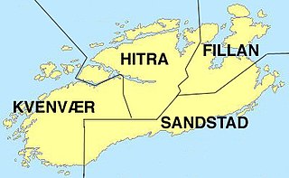
Fillan is a former municipality in the old Sør-Trøndelag county, Norway. The former municipality is now part of the municipality of Hitra in Trøndelag county. The municipality included the northeastern part of the island of Hitra surrounding the Fillfjorden, plus about 100 islands, islets, and skerries—including Fjellværsøya and Ulvøya. The administrative centre of the municipality was the village of Fillan. Other villages in the municipality included Ansnes, Nordbotn, and Ulvan.


