
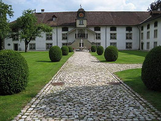
Steinbrugg Castle is a castle in the municipality of Solothurn of the Canton of Solothurn in Switzerland. It is a Swiss heritage site of national significance. [1]
Steinbrugg Castle is a castle in the municipality of Solothurn of the Canton of Solothurn in Switzerland. It is a Swiss heritage site of national significance. [1]

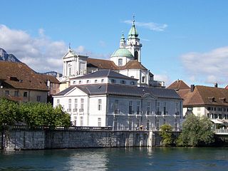
Solothurn is a town, a municipality, and the capital of the canton of Solothurn in Switzerland. It is located in the north-west of Switzerland on the banks of the Aare and on the foot of the Weissenstein Jura mountains.

The Battle of Dornach was fought on 22 July 1499 between the troops of Emperor Maximilian I and the Old Swiss Confederacy, close to the Swiss village of Dornach. The battle ended in a decisive defeat for Maximilian, and concluded the Swabian War between the Swiss and the Swabian League.
Beinwil Abbey was a Benedictine monastery in Beinwil in the Canton of Solothurn in Switzerland.

Altstadt is the German language word for "old town", and generally refers to the historical town or city centre within the old town or city wall, in contrast to younger suburbs outside. Neustadt, the logical opposite of Altstadt, mostly stands for a part of the "Altstadt" in modern sense, sometimes only a few years younger than the oldest part, e. g. a late medieval enlargement.

Utzenstorf is a municipality in the administrative district of Emmental in the canton of Bern in Switzerland. It is regionally famous for its medieval castle, Landshut Castle.

Wasseramt District is one of the ten districts of the canton of Solothurn in Switzerland, situated to the south of the canton. Together with the Bucheggberg District, it forms the Amtei of Wasseramt-Bucheggberg. It has a population of 52,949.

Northwestern Switzerland, as defined by the Federal Statistical Office for statistical purposes, is a NUTS-2 region of Switzerland. As it encompasses the entire cantons of Basel-Stadt, Basel-Landschaft, and Aargau, it does not cover the same area as the traditional region of the same name, which also includes Basel-Stadt and Basel-Landschaft, but also certain northern parts of the canton of Solothurn and only parts of the canton of Aargau.

Petinesca is an archeological site on the territory of Studen, a community of the Canton of Bern, in Switzerland, where Celtic and Roman vestiges were found.
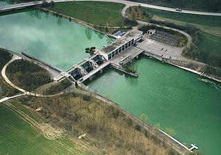
The Flumenthal Dam is a regulating dam at Flumenthal, Switzerland, which was erected as the most important element of all the works of the Second Jura water correction. It was built to regulate the outflow of Seeland's three-lake hydrologic system as far downstream as Solothurn and the confluence with the river Emme River. It works in conjunction with the Regulating Dam Port at Seeland. The works started in 1966, and the dam and adjoining downstream hydroelectric power station were commissioned in 1970.
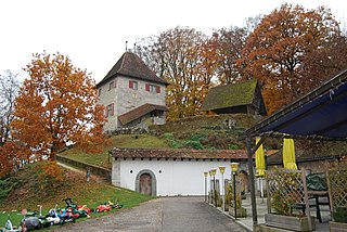
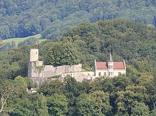
Buchegg Castle is a castle in the Swiss municipality of Kyburg-Buchegg in the canton of Solothurn, Switzerland.
Stadion FC Solothurn is a football stadium in Solothurn, Switzerland. It is the home ground of FC Solothurn and has a capacity of 6,750.
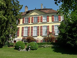
Blumenstein Castle is an estate house in the municipality of Solothurn of the Canton of Solothurn in Switzerland. It is a Swiss heritage site of national significance. In 1952 it became the home of the Historical Museum of Solothurn.

The Kunstmuseum Solothurn or Art Museum Solothurn is an art museum in the Swiss town Solothurn.
Fraubrunnen Abbey is a former Cistercian nunnery in the municipality of Fraubrunnen in the canton of Bern, Switzerland.

Aargauische Kantonalbank is a cantonal bank based in the canton of Aargau, Switzerland. Its head office is situated at Aarau (AG). Founded in 1913, Aargau Cantonal Bank in 2021 had 832 employees and 32 offices in Switzerland, total assets were 31 777.48 mln CHF.
The capture of Porrentruy was a siege of the Swiss town of Porrentruy. The town was held by Austria and attacked by the French. The event occurred on 28 April 1792 and resulted in victory for the French forces. This engagement marked the commencement of the War of the First Coalition.
Bipp Castle is a partially ruined castle in the municipality of Oberbipp of the Canton of Bern in Switzerland.

The Aarewaage is a whirlpool phenomenon in the Swiss river Aare at Aarburg, canton of Aargau. In 1996, it was added to the Federal Inventory of Landscapes and Natural Monuments.
The Kantonales Kulturzentrum Palais Besenval was a state cultural center in the Swiss town of Solothurn that existed from 1990 to 2000. It was located in the Palais Besenval at Kronengasse 1 and served mainly as a Kunsthalle.
The University of Applied Sciences and Arts Northwestern Switzerland is a university of applied sciences in Switzerland. It is one of the largest universities in the country in terms of student enrollment. It is an inter-cantonal public law institution with its own legal personality. The cantons are Aargau, Basel-Landschaft, Basel-Stadt, and Solothurn.
47°12′44″N7°32′48″E / 47.212217°N 7.546575°E
| | This article about a castle in Switzerland is a stub. You can help Wikipedia by expanding it. |