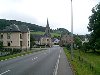
Steinheim (Luxembourgish : Steenem) is a town in the commune of Rosport-Mompach, in eastern Luxembourg. As of 2024 [update] , the town has a population of 654. [1]

Steinheim (Luxembourgish : Steenem) is a town in the commune of Rosport-Mompach, in eastern Luxembourg. As of 2024 [update] , the town has a population of 654. [1]
This is a list of the extreme points of the United Kingdom: the points that are farther north, south, east or west than any other location. Traditionally the extent of the island of Great Britain has stretched "from Land's End to John o' Groats".

Wasserbillig is a town in the commune of Mertert, in eastern Luxembourg. As of 2024, Wasserbillig has 3,485 inhabitants, which makes it the largest town in Mertert. Wasserbillig is the administrative seat of the commune of Mertert.

Caleruega is a small town and municipality in the autonomous community of Castile-Leon, Spain. It is part of the Province of Burgos. The town is a few miles south of the Monastery of Santo Domingo de Silos.

Remerschen is a former commune and small wine-growing town in south-eastern Luxembourg, belonging to the commune of Schengen, near the point where the borders of Germany, France and Luxembourg come together.
Nuevo Edén de San Juan is a municipality in the San Miguel department of El Salvador.

Howald is a town in the commune of Hesperange, in southern Luxembourg. The town merges almost seamlessly with Luxembourg City's south-eastern suburban quarter of South Bonnevoie, which lies to the north of Howald. As of 2024, the town has a population of 5,815, making it the most populous town in the commune and the 22nd-most populous in Luxembourg.

Gilsdorf is a small town in the commune of Bettendorf, in north-eastern Luxembourg. As of 2024, the town has a population of 1,145.
Tétange is a town in the commune of Kayl, in south-western Luxembourg. As of 2024, the town has a population of 4,033. Schlager singer Camillo Felgen and Olympic cyclist Roger Thull were born here.

Kockelscheuer is a small town in the commune of Roeser, in southern Luxembourg. As of 2024, the town has a population of 284. The Fortis Championships Luxembourg are held at the Kockelscheuer Sport Centre, just to the north of the town. The 2014 IIHF World Championship Division III were held at the Kockelscheuer Ice Rink in April 2014. Each year Kockelscheuer held sponsored by BGL a tennis tournament, part of WTA.

Colpach-Haut is a village in the commune of Ell, in western Luxembourg. As of 2024, the village has a population of 329.
Bilsdorf is a village in the commune of Rambrouch, in western Luxembourg. As of 2024, the village had a population of 179. Olympian Nico Klein was born here.

Folschette is a small town in the commune of Rambrouch, in western Luxembourg. As of 2024, the town has a population of 490.
Perlé is a small town in the commune of Rambrouch, in western Luxembourg. As of 2024, the town has a population of 912.
Michelbouch is a village in the commune of Vichten, in central Luxembourg. As of 2024, the village has a population of 179.

Wintrange is a small town in the commune of Schengen, in southeastern Luxembourg. As of 2024, the town has a population of 483.
Layang-Layang is a town in Kluang District, Johor, Malaysia. It is situated within the parliamentary constituency of Simpang Renggam.

Brehov is a village and municipality in the Trebišov District in the Košice Region of eastern Slovakia.

Tori is a municipality located in Pärnu County.
Nyírvasvári is a village in Szabolcs-Szatmár-Bereg county, in the Northern Great Plain region of eastern Hungary.

This is a list of the extreme points of Luxembourg, the points that are farther north, south, east or west, higher or lower than any other location in the territory of the state.
49°49′N6°29′E / 49.817°N 6.483°E