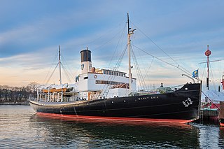
SS Sankt Erik is an icebreaker and museum ship attached to the Vasa Museum in Stockholm, Sweden.

Kotayk, formerly known as Yelgovan, is a village in the Kotayk Province of Armenia.

Dambulaq is a village in the Lachin District of Azerbaijan.
Əli Bayramlı is a village in the Qakh Rayon of Azerbaijan.

Jaksice is a village in the administrative district of Gmina Miechów, within Miechów County, Lesser Poland Voivodeship, in southern Poland. It lies approximately 5 kilometres (3 mi) south-west of Miechów and 30 km (19 mi) north of the regional capital Kraków.
Dwory II is a village in the administrative district of Gmina Oświęcim, within Oświęcim County, Lesser Poland Voivodeship, in southern Poland.
Kobylniki is a village in the administrative district of Gmina Wiślica, within Busko County, Świętokrzyskie Voivodeship, in south-central Poland. It lies approximately 4 kilometres (2 mi) north of Wiślica, 11 km (7 mi) south-west of Busko-Zdrój, and 56 km (35 mi) south of the regional capital Kielce.
Koniecmosty is a village in the administrative district of Gmina Wiślica, within Busko County, Świętokrzyskie Voivodeship, in south-central Poland. It lies approximately 2 kilometres (1 mi) south-west of Wiślica, 15 km (9 mi) south of Busko-Zdrój, and 61 km (38 mi) south of the regional capital Kielce.

Pingyuan County is a county in the northeast of Guangdong Province, People's Republic of China. It is under the administration of Meizhou City.
Kolonia Pęcławska is a village in the administrative district of Gmina Bogoria, within Staszów County, Świętokrzyskie Voivodeship, in south-central Poland. It lies approximately 6 kilometres (4 mi) east of Bogoria, 15 km (9 mi) north-east of Staszów, and 57 km (35 mi) south-east of the regional capital Kielce.
Honoratka is a village in the administrative district of Gmina Ślesin, within Konin County, Greater Poland Voivodeship, in west-central Poland.
Różki is a village in the administrative district of Gmina Kołczygłowy, within Bytów County, Pomeranian Voivodeship, in northern Poland. It lies approximately 8 kilometres (5 mi) north-east of Kołczygłowy, 20 km (12 mi) north-west of Bytów, and 86 km (53 mi) west of the regional capital Gdańsk.
Piotrowo is a settlement in the administrative district of Gmina Nowa Wieś Lęborska, within Lębork County, Pomeranian Voivodeship, in northern Poland. It lies approximately 12 kilometres (7 mi) north of Nowa Wieś Lęborska, 13 km (8 mi) north of Lębork, and 65 km (40 mi) north-west of the regional capital Gdańsk.
Tolpity is a settlement in the administrative district of Gmina Pasłęk, within Elbląg County, Warmian-Masurian Voivodeship, in northern Poland. It lies approximately 6 kilometres (4 mi) south of Pasłęk, 20 km (12 mi) south-east of Elbląg, and 61 km (38 mi) north-west of the regional capital Olsztyn.

An Ninh is a commune (xã) and village in Quảng Ninh District, Quảng Bình Province, Vietnam.

Buenos Aires is a city located in the state of Pernambuco, Brazil. Located 78 km from the state capital of Recife, it has an estimated population of 13,190 people.

Bubušinac is a village in the municipality of Požarevac, Serbia. According to the 2002 census, the village has a population of 844 people.
Axaxdərə is a village in the Zaqatala Rayon of Azerbaijan. The village forms part of the municipality of Car.

Eynali Cable is a gondola lift in Mount Eynali at North of Tabriz, Iran. The lift is designed to be a three stage lift and the first phase is operational since Fall 2010. The first station is in the foothills of the Eynali and it goes up to Zoroasterian temple at the local peak of Eynali.

Carrizo Gorge is a valley in the Jacumba Mountains, in San Diego County, California. Its mouth is at an elevation of 1,411 feet / 430 meters, where it widens out to become Carrizo Canyon, 1 mile northeast of Palm Grove. Its head is located in the Jacumba Mountains, 1.5 miles north of Round Mountain, at and elevation of 2,600 feet, at 32°39′38″N116°11′28″W.
