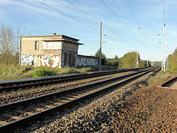
Stellwerk Fichtengrund is a decommissioned railway signal box on the outskirts of Berlin in Oranienburg, Germany, formerly in the GDR. It was built in 1964 by the GDR railway Deutsche Reichsbahn to operate the connection to, what was at the time, a secret rail track connecting the Prussian Northern Railway with the Heidekrautbahn. The track, which was omitted from maps during the GDR period, was used to test a new Telescopic Axle to allow train coaches to easily change from European to Russian track gauge. [1] The prototype worked but was never put into mass production.
Berlin is the capital and largest city of Germany by both area and population. Its 3,748,148 (2018) inhabitants make it the second most populous city proper of the European Union after London. The city is one of Germany's 16 federal states. It is surrounded by the state of Brandenburg, and contiguous with its capital, Potsdam. The two cities are at the center of the Berlin-Brandenburg capital region, which is, with about six million inhabitants and an area of more than 30,000 km², Germany's third-largest metropolitan region after the Rhine-Ruhr and Rhine-Main regions.
Oranienburg is a town in Brandenburg, Germany. It is the capital of the district of Oberhavel.
East Germany, officially the German Democratic Republic, was a country that existed from 1949 to 1990, when the eastern portion of Germany was part of the Eastern Bloc during the Cold War. It described itself as a socialist "workers' and peasants' state", and the territory was administered and occupied by Soviet forces at the end of World War II — the Soviet Occupation Zone of the Potsdam Agreement, bounded on the east by the Oder–Neisse line. The Soviet zone surrounded West Berlin but did not include it; as a result, West Berlin remained outside the jurisdiction of the GDR.
The Stellwerk [2] operated a type GS II DR [3] point control system and the structure was designed by the building department of the Deutsche Reichsbahn. [4] The building consists of a block containing the control centre with radial viewing windows and a separate part containing the electrical relay rooms. The construction of all walls, floors and roofs is predominantly from pre-cast or in-situ cast steel reinforced concrete with a rendered outer coating on the walls; building materials and method which were fashionable during that period in the GDR.
The Reichsbahn built several virtually identical buildings situated in Birkenwerder, [5] Satzkorn, [6] Hohen-Neuendorf-West [7] and Schönfließ. [8]
On 20 March 2012 the exterior of the building was awarded protected building status - added to the "Denkmalliste des Landes Brandenburg".
West Berlin was a political enclave which comprised the western part of Berlin during the years of the Cold War. There was no specific date on which the sectors of Berlin occupied by the Western Allies became "West Berlin", but 1949 is widely accepted as the year in which the name was adopted. West Berlin aligned itself politically with the Federal Republic of Germany and was directly or indirectly represented in its federal institutions.
The Berlin S-Bahn[ɛs.baːn] is a rapid transit railway system in and around Berlin, the capital city of Germany. It has been in operation under this name since December 1930, having been previously called the special tariff area Berliner Stadt-, Ring- und Vorortbahnen. It complements the Berlin U-Bahn and is the link to many outer-Berlin areas, such as Berlin Schönefeld Airport.
U9 is a line on the Berlin U-Bahn. The line was opened on 28 August 1961 as Line G.
Berlin Jungfernheide is a railway station located at Charlottenburg-Nord, in the Charlottenburg-Wilmersdorf district of Berlin, served by the S-Bahn lines S 41 and S 42, the U-Bahn line U 7 and Regional-Express trains of the Deutsche Bahn. Its name literally translates into "maidens' heathland"; it was named after the Jungfernheide, a former large forest in the proximity of this station.
The Deutsche Bundesbahn or DB was formed as the state railway of the newly established Federal Republic of Germany (FRG) on 7 September 1949 as a successor of the Deutsche Reichsbahn-Gesellschaft (DRG). The DB remained the state railway of West Germany until after German reunification, when it was merged with the former East German Deutsche Reichsbahn (DR) to form Deutsche Bahn AG, which came into existence on 1 January 1994.
The Berliner Verkehrsbetriebe is the main public transport company of Berlin, the capital city of Germany. It manages the city's U-Bahn underground railway, tram, bus, replacement services (EV) and ferry networks, but not the S-Bahn urban rail system.
The Deutsche Reichsbahn or DR(German Reich Railways) was the operating name of state owned railways in the German Democratic Republic, and after German reunification until 31 December 1993.
Tempelhof is a railway station in the district of Berlin with the same name. It is served by the S-Bahn lines S 41, S 42, S 45 and S 46 and the U-Bahn line U 6. The S-Bahn station is on an embankment at the junction of Tempelhofer Damm and Bundesautobahn 100, about 1 km south of the entrance to the former Tempelhof Airport. The U-Bahn station, officially called Tempelhof (Südring), is under Tempelhofer Damm immediately south of the S-Bahn station.
Berlin Hermannstraße is a railway station in the Neukölln district of Berlin. It is served by the S-Bahn lines S 41, S 42, S 45, S 46 and S 47 and the U-Bahn line U 8, of which it is the southern terminus. It was formerly also possible to transfer there to the Neukölln-Mittenwalde railway line, which is now only used for goods traffic.
The Berlin Stadtbahn is a major railway thoroughfare in the German capital Berlin, which runs through Berlin from east to west. It connects the eastern district of Friedrichshain with Charlottenburg in the west via 11 intermediate stations including Hauptbahnhof. The Berlin Stadtbahn is often also defined as the slightly longer route between Ostkreuz and Westkreuz, although this is not technically correct.
Berlin-Charlottenburg is a railway station in the Charlottenburg district of Berlin. The station is located on the Stadtbahn line, served by the S 3, S 5, S 7, and S 9 lines of the Berlin S-Bahn, as well as by Regional-Express and Regionalbahn trains operated by Deutsche Bahn. The U-Bahn station Wilmersdorfer Straße (U7) can be reached via short footpath.
Berliner Tor is a transport hub in Hamburg, Germany, served by the Hamburg U-Bahn and the Hamburg S-Bahn. The station is located in St. Georg, part of the borough of Hamburg-Mitte.
Hof Hauptbahnhof is the main railway station in Hof in southern Germany and is situated at the intersection of the Saxon-Franconian trunk line (Magistrale) and the Munich–Regensburg–Leipzig–Berlin line. When it was opened it formed the boundary between the former Bavarian Ludwig South-North Railway Lindau–Hof to the Saxon-Bavarian Railway on the Saxon side from Hof–Leipzig.
Berlin-Lichterfelde Ost station is on the Anhalt Suburban Line in Lichterfelde in the Berlin borough of Steglitz-Zehlendorf. It is served by S-Bahn line S25, S-Bahn line S26, and Regional-Express lines 3, 4 and 5.
Berlin Albrechtshof is a railway station located in Staaken, a locality in the Spandau district of Berlin. It is, also with Berlin Staaken, the only Berliner DB station not served by the S-Bahn.
The Berlin outer ring is a 125 km (78 mi) long double track electrified railway, originally built by the German Democratic Republic to bypass West Berlin in preparation for the building of the Berlin Wall during the division of Germany. It was developed by East Germany for economic, transport policy, and military reasons between 1951 and 1961 and included parts of some older lines.
Potsdam Park Sanssouci is a German railway station located in Potsdam, the Brandenburger capital city on the Berlin–Magdeburg railway. Named Potsdam Wildpark until 1999, it serves the Sanssouci Park and is famous for the Kaiserbahnhof building.
Berlin Brandenburg Airport is a future railway station located under the terminal of Berlin Brandenburg Airport, Germany. The train services will be operated by Deutsche Bahn.
The Woltersdorf Tramway is a standard gauge tramway, located in Woltersdorf, Brandenburg, Near Berlin, Germany. The line is notable for its use of historic vehicles, using 4 wheeled trams, built in the early 1960s. The line was constructed in 1913, to connect Woltersdorf to the Berlin Suburban railways. It is one of the smallest tram operators in Germany, and has not expanded beyond its 1913 route.
Coordinates: 52°46′35″N13°15′13″E / 52.7764°N 13.2535°E
A geographic coordinate system is a coordinate system that enables every location on Earth to be specified by a set of numbers, letters or symbols. The coordinates are often chosen such that one of the numbers represents a vertical position and two or three of the numbers represent a horizontal position; alternatively, a geographic position may be expressed in a combined three-dimensional Cartesian vector. A common choice of coordinates is latitude, longitude and elevation. To specify a location on a plane requires a map projection.