Bethnal Green is an area in the East End of London 3 miles (4.8 km) northeast of Charing Cross. The area emerged from the small settlement which developed around the Green, much of which survives today as Bethnal Green Gardens, beside Cambridge Heath Road. By the 16th century the term applied to a wider rural area, the Hamlet of Bethnal Green, which subsequently became a Parish, then a Metropolitan Borough before merging with neighbouring areas to become the north-western part of the new London Borough of Tower Hamlets.

Stepney is a district in the East End of London in the London Borough of Tower Hamlets. The district is no longer officially defined, and is usually used to refer to a relatively small area. However, for much of its history the place name applied to a much larger manor and parish. Stepney Green is a remnant of a larger area of Common Land formerly known as Mile End Green.

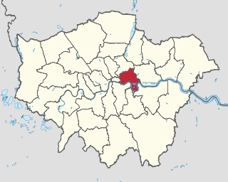
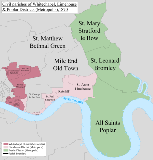
The London Borough of Tower Hamlets is a London borough covering much of the traditional East End. It was formed in 1965 from the merger of the former metropolitan boroughs of Stepney, Poplar, and Bethnal Green. 'Tower Hamlets' was originally an alternative name for the historic Tower Division; the area of south-east Middlesex, focused on the area of the modern borough, which owed military service to the Tower of London.

Bethnal Green was a civil parish and a metropolitan borough in the East End of London, England.

The Metropolitan Borough of Stepney was a Metropolitan borough in the County of London created in 1900. In 1965 it became part of the London Borough of Tower Hamlets.

Brick Lane is a street in the East End of London, in the borough of Tower Hamlets. It runs from Swanfield Street in Bethnal Green in the north, crosses the Bethnal Green Road before reaching the busiest, most commercially active part which runs through Spitalfields, or along its eastern edge. Brick Lane’s southern end is connected to Whitechapel High Street by a short extension called Osborn Street.

Mile End is a district of the London Borough of Tower Hamlets in the East End of London, England, 4.2 miles (6.8 km) east-northeast of Charing Cross. Situated on the London-to-Colchester road, it was one of the earliest suburbs of London. It became part of the metropolitan area in 1855, and is connected to the London Underground.

Bow Church is the parish church of St Mary and Holy Trinity, Stratford, Bow. It is located on a central reservation site in Bow Road, in Bow, in the London Borough of Tower Hamlets. There has been a church on the same site for approximately 700 years. The church was bombed in the Second World War, and the bell tower was reconstructed just after the war.

Lakeview Estate is a housing estate in Old Ford, east London designed by Berthold Lubetkin. It was built on a site damaged by bombing in World War II, on Grove Road between Old Ford Road and the Hertford Union Canal. The estate opened in 1958. It overlooks the lake in Victoria Park.

Eastminster, also known as New Abbey, St Mary Graces, and other variants, was a Cistercian abbey on Tower Hill at East Smithfield in London. It was founded by Edward III in 1350 immediately outside the Roman London Wall in what is now the London Borough of Tower Hamlets. It stood just to the north of an older royal foundation, the Hospital and Collegiate Church of St Katharine by the Tower.

Rainham Hall is a Grade II* listed Georgian house, owned by the National Trust, in Rainham, in the London Borough of Havering. Built in 1729 for Captain John Harle, the house was transferred to the National Trust in 1949; let to a number of private tenants, it remained closed to the public until late 2015. Of note is that Rainham Hall recently appeared as a location in the 2019 BBC production of A Christmas Carol.

Mile End New Town is a former hamlet and then civil parish in the East End of London. Its former area is now part of the London Borough of Tower Hamlets.

Stepney was an ancient civil and ecclesiastical parish in the historic county of Middlesex to the east and north east of the City of London, England.

St Barnabas Bethnal Green is a late 19th-century church in Bow in London, England. It is an Anglican church in the Diocese of London. The church is at the junction of Roman Road and Grove Road in the Bow West ward of London Borough of Tower Hamlets.

Stepney City Farm is a city farm in Stepney, London, England. It is situated on Stepney Way with its entrance on the roundabout leading onto Stepney High Street and Belgrave Street towards Limehouse. The land is owned by Tower Hamlets Council through a trust, "The King George's Fields Trust" chaired by the Mayor of Tower Hamlets.

The Oregonian Printing Press Park, or simply Printing Press Park, is a triangular 1,000-square-foot park on the southeastern corner of the intersection of Southwest First Avenue and Morrison Street in Portland, Oregon, United States. The green space marks where editor Thomas J. Dryer operated a small press to publish Portland's weekly newspaper, which would become The Oregonian, beginning on December 4, 1850.

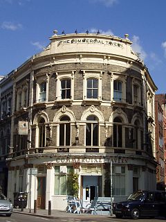
The Commercial Tavern is a pub at 142 Commercial Street, Spitalfields, Shoreditch, London E1.

The Baptist College, Stepney, was opened in Stepney in the East End of London in 1810 by the Particular Baptists. Its buildings included rooms for tutors and students, a refectory, a library and a chapel. The college relocated to larger premises at Holford House in 1856 and became Regent's Park College.

Stepney Green cavern is an underground junction which contains the junction where Crossrail divides into two branches: one to Shenfield and one to Abbey Wood. It is located below Stepney Green Park. At the time of its completion in 2017, Stepney Green cavern was claimed to have been one of the largest mined caverns in Europe.

The Bethnal Green mulberry tree is an ancient black mulberry tree, in the grounds of the former London Chest Hospital, at Bethnal Green in the London Borough of Tower Hamlets.


