
Monterey Bay is a bay of the Pacific Ocean located on the coast of the U.S. state of California, south of the San Francisco Bay Area. San Francisco itself is further north along the coast, by about 75 miles, accessible via CA 1 and US 101.

The Central Coast is an area of California, roughly spanning the coastal region between Point Mugu and Monterey Bay. It lies northwest of Los Angeles and south of the San Francisco Bay Area, and includes the rugged, rural, and sparsely populated stretch of coastline known as Big Sur.

Asilomar State Beach, officially Asilomar State Beach and Conference Grounds State Park, is a state park unit of California, United States. It provides public access to rocky coast and dune habitat on the Monterey Peninsula. The property includes the Asilomar Conference Grounds, a conference center built by the YWCA in 1913 that is now a National Historic Landmark. The 107-acre (43 ha) site is located in Pacific Grove and offers overnight lodging and views of the forest, surf and sand.

Pebble Beach is an unincorporated community on the Monterey Peninsula in Monterey County, California, United States. The small coastal residential community of mostly single-family homes is also notable as a resort destination, and the home of the golf courses of Cypress Point Club, Monterey Peninsula Country Club, and Pebble Beach Golf Links. Nonresidents are charged a toll to use 17-Mile Drive, the main road through Pebble Beach, making it a de-facto gated community.
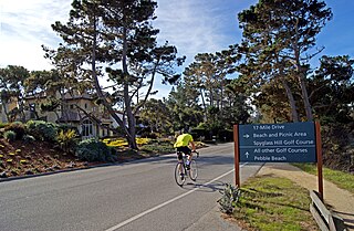
17-Mile Drive is a scenic road through Pebble Beach and Pacific Grove on the Monterey Peninsula in California, much of which hugs the Pacific coastline and passes famous golf courses, mansions and scenic attractions, including the Lone Cypress, Bird Rock and the 5,300-acre Del Monte Forest of Monterey Cypress trees.

Fitzgerald Marine Reserve is a marine reserve in California on the Pacific Ocean, located just north of Pillar Point Harbor and Mavericks in the San Mateo County community of Moss Beach. Moss Beach is located approximately 20 miles (32 km) south of San Francisco and 50 miles (80 km) north of Santa Cruz. The reserve is a 32-acre (0.13 km2) holding which extends from Montara light station at the north to Pillar Point on the south. The reserve consists of a three-mile stretch of beach, tidepool habitat, marsh, erosive bluffs, clifftop trail and cypress and eucalyptus forests. The property is owned by the State of California and managed by San Mateo County as a county park and nature preserve. The reserve is administratively assigned to be part of the Monterey Bay National Marine Sanctuary. Adjacent to and possibly within the reserve is an endangered species of butterfly, the San Bruno elfin butterfly.

Pescadero is an unincorporated town and census-designated place (CDP) in San Mateo County, California, two miles (3 km) east of State Route 1 and Pescadero State Beach. The town is 14.4 miles (23.2 km) south of Half Moon Bay. The ZIP Code is 94060 and the community is inside area code 650. The population was 595 at the 2020 census.

The Monterey Bay National Marine Sanctuary (MBNMS) is a federally protected marine area offshore of California's Big Sur and central coast in the United States. It is the largest US national marine sanctuary and has a shoreline length of 276 miles (444 km) stretching from just north of the Golden Gate Bridge at San Francisco to Cambria in San Luis Obispo County. Supporting one of the world's most diverse marine ecosystems, it is home to numerous mammals, seabirds, fishes, invertebrates and plants in a remarkably productive coastal environment. The MBNMS was established in 1992 for the purpose of resource protection, research, education, and public use.
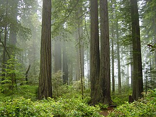
The Northern California coastal forests are a temperate coniferous forests ecoregion of coastal Northern California and southwestern Oregon.

Point Lobos and the Point Lobos State Natural Reserve is a state park in California. Adjoining Point Lobos is "one of the richest marine habitats in California." The ocean habitat is protected by two marine protected areas, the Point Lobos State Marine Reserve and Point Lobos State Marine Conservation Area. The sea near Point Lobos is considered one of the best locations for scuba diving on the Monterey Peninsula and along the California coast.

New Brighton State Beach is a 95 acres (38 ha) beach park on Monterey Bay in Santa Cruz County, California, consisting of a beach and campgrounds. The park is located east of Santa Cruz in Capitola, on Park Avenue off of Highway 1. The park is adjacent to Seacliff State Beach, which is known for its fishing pier and sunk concrete freighter, The Palo Alto. The beach overlooks Soquel Cove and Monterey Bay.
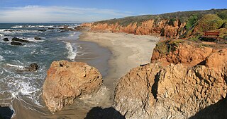
Pescadero State Beach is alongside State Route 1, located 14.5 miles (23.3 km) south of Half Moon Bay and 1.5 miles (2.4 km) west of the city of Pescadero, in San Mateo County, California. The beach has a 1 mile (1.6 km)-long shoreline with sandy coves, rocky cliffs, tide pools, fishing spots and picnic facilities.
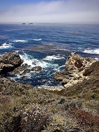
Garrapata State Park is a state park of California, United States, located on California State Route 1 6.7 miles (10.8 km) south of Carmel-by-the-Sea and 18 miles (29 km) north of Big Sur Village on the Monterey coast. The 2,939-acre (1,189 ha) park was established in 1979. California sea lions, harbor seals and sea otters frequent the coastal waters while gray whales pass close by during their yearly migration.
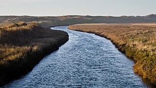
Pescadero Creek is a major stream in Santa Cruz and San Mateo counties in California, United States. At 26.6 miles (42.8 km), it is the longest stream in San Mateo County and flows all year from springs in the Santa Cruz Mountains. Its source is at 1,880 feet (570 m) above sea level on the western edge of Castle Rock State Park, with additional headwaters in Portola Redwoods State Park, and its course traverses Pescadero Creek County Park and San Mateo County Memorial Park before entering Pescadero Marsh Natural Preserve at Pescadero State Beach and thence to the Pacific Ocean 14.4 miles (23 km) south of Half Moon Bay.

Butano Creek, name is a 15 miles (24 km) stream in San Mateo County, California, and carries a large amount of the runoff of the Santa Cruz Mountains into the Pacific Ocean after joining the Pescadero Creek delta at Pescadero Marsh in San Mateo County, California.
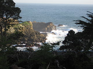
Stillwater Cove Regional Park is a regional park north of Jenner, California, U.S.A. that is maintained by the Sonoma County Regional Parks Department. It is located near the mouth of Stockhoff Creek. Access is by means of State Route 1. It was one of the filming locations for 20th Century Fox's 1947 fantasy film, The Ghost and Mrs. Muir.

Rancho San José y Sur Chiquito was a 8,876-acre (35.92 km2) Mexican land grant in present-day Big Sur, in Monterey County, California, given in 1835 to Teodoro Gonzalez and re-granted by Governor Juan Alvarado the same year to Marcelino Escobar. The grant, including Point Lobos, was located south of the Carmel River, extending inland along the coastal mountains, and south along the Pacific coast. It included San Jose Creek, Malpaso Creek, Soberanes Creek, Tres Pinos Creek, Garrapata Creek, and ended on the north side of Palo Colorado Canyon. A hand-drawn map created c. 1853 accompanying the grant indicated a road or trail was already present along the coast.

Lovers Point State Marine Reserve (SMR) is one of four small marine protected areas located near the cities of Monterey and Pacific Grove, at the southern end of Monterey Bay on California’s central coast. The four MPAs together encompass 2.96 square miles (7.7 km2). The SMR protects all marine life within its boundaries. Fishing and take of all living marine resources is prohibited.


