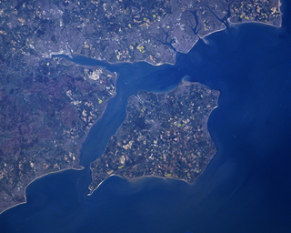
The Solent is a strait between the Isle of Wight and mainland Great Britain; the major historic ports of Southampton and Portsmouth lie inland of its shores. It is about 20 miles long and varies in width between 2+1⁄2 and 5 mi, although the Hurst Spit which projects 1+1⁄2 mi (2.4 km) into the Solent narrows the sea crossing between Hurst Castle and Colwell Bay to just over 1 mi (1.6 km).

Gosport is a town and non-metropolitan borough, on the south coast of Hampshire, South East England. At the 2021 Census, its population was 81,952. Gosport is situated on a peninsula on the western side of Portsmouth Harbour, opposite the city of Portsmouth, to which it is linked by the Gosport Ferry. Gosport lies south-east of Fareham, to which it is linked by a Bus Rapid Transit route and the A32. Until the last quarter of the 20th century, Gosport was a major naval town associated with the defence and supply infrastructure of His Majesty's Naval Base (HMNB) Portsmouth. As such over the years extensive fortifications were created.

Lee-on-the-Solent, often referred to as Lee-on-Solent, is a seaside district of the borough of Gosport in Hampshire, England, about five miles (8 km) west of Portsmouth. The area is located on the coast of the Solent. It is primarily a residential area, with an upsurge of mostly local visitors in summer, but was also the former home to the Royal Naval Air Station HMS Daedalus.

Fort Gilkicker is a historic Palmerston fort built at the eastern end of Stokes Bay, Gosport, Hampshire England to dominate the key anchorage of Spithead. It was erected between 1863 and 1871 as a semi-circular arc with 22 casemates, to be armed with five twelve-inch guns, seventeen ten-inch guns and five nine-inch guns. The actual installed armament rather differed from this. In 1902 the RML guns were replaced by two 9.2-inch and two six-inch BL guns, and before the First World War the walls were further strengthened with substantial earthwork embankments. The fort was disarmed in 1956 and used for storage until 1999. On 28th July 2022, the fort was sold at auction for just under £1.4M and planning has been granted for 26 homes. Since then a massive restoration project has been underway.

Ryde Pier is an early 19th century pier serving the town of Ryde, on the Isle of Wight, off the south coast of England. It is the world's oldest seaside pleasure pier. Ryde Pier Head railway station is at the sea end of the pier, and Ryde Esplanade railway station at the land end, both served by Island Line trains.

Portsmouth Harbour is a 1,264.2-hectare (3,124-acre)/12.6 km2 (4.9 sq mi) biological Site of Special Scientific Interest between Portsmouth and Gosport in Hampshire. It is a Ramsar site and a Special Protection Area.

Portsmouth Harbour railway station serves the city of Portsmouth, in Hampshire, England. It is situated in Portsmouth Harbour, between the Gunwharf Quays shopping centre and the Historic Dockyard. It is an important transport terminal, with a bus interchange and ferry services to Gosport and the Isle of Wight. Unusually for a main line railway station, it is built over water as the station was originally constructed on wooden piles, which were later replaced by iron supports.

Fareham railway station is on the West Coastway Line, situated about 0.62 miles (1 km) from the town of Fareham in Hampshire, England. It is 84 miles 21 chains (135.6 km) down the line from London Waterloo.

Ryde Pier Head railway station is one of three stations in the town of Ryde on the Isle of Wight. Situated at the end of the town's pier, it is adjacent to the terminal for the Wightlink fast catamaran service connecting the island with Portsmouth on the English mainland. Passengers can use this to connect with the rest of the National Rail network at Portsmouth Harbour station, which is adjacent to the Portsmouth terminal. Through rail tickets for travel via Pier Head station are available to and from other stations on the Isle of Wight. These include travel on the catamaran service to or from Portsmouth as appropriate.

Alverstoke is a village in the borough of Gosport, on the south coast of Hampshire, England. It stretches east–west from Fort Blockhouse, Haslar to Browndown Battery, and is centred 0.5 miles (0.80 km) east of the shore of Stokes Bay and near the head of a creek which extends a mile westward from Portsmouth Harbour.

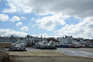
There are currently three different ferry companies that operate vessels carrying passengers and, on certain routes, vehicles across the Solent, the stretch of sea that separates the Isle of Wight from mainland England. These are Wightlink, Red Funnel and Hovertravel.
The Gosport and Cosham lines were a collection of railway lines in southern Hampshire. Most of the lines are now closed but some elements are still in use, forming part of the West Coastway line. The lines originally linked to the main London to Southampton line via the Eastleigh–Fareham line and subsequently with a line from Southampton via Bursledon, both of which are still in use.

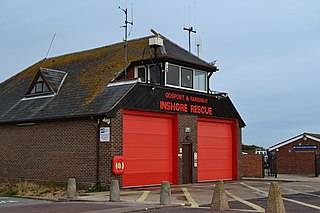
Gosport Lifeboat Station is a volunteer-operated independent lifeboat station charity located in the village of Alverstoke on the peninsula of Gosport in the English county of Hampshire. Owned and operated by Gosport and Fareham Inshore Rescue Service (GAFIRS), it operates free lifeboat services in the Solent from Portsmouth Harbour to Titchfield Haven, on the approaching shores of Southampton Water. GAFIRS is a charity registered in England and Wales (1159681).
The Stokes Bay line was a short railway branch line in Hampshire, England, near Gosport. Associated with a new pier, it was intended to give direct and easy access from trains to steamers to the Isle of Wight in comparison to the conventional route through Portsmouth, which required a road transport connection though the town. Railway operation to the Stokes Bay pier started in 1863.

The Funtley Deviation was a 2-mile long double track railway opened as a single line in 1904 and as a double line in 1906 to provide an alternative to the 1841 railway line north of Fareham which traversed the precarious Fareham tunnel. Unfortunately the deviation line suffered from stability problems of its own and it was eventually closed on 6 May 1973, in favour of the original route, and is now a nature walk with a small car park at the Highlands Road end. The route south of Highlands Road was sold for housing.

The Stokes Bay Lines were part of the great Victorian fortification of Portsmouth Harbour under Lord Palmerston. In 1857 Major Jervois had proposed a complex system of moats (ditches), ramparts and batteries to close off the gap between the new fort at Fort Gomer, and the earlier fort at Fort Gilkicker, and Fort Monckton. This defensive moat was to become the ‘Stokes Bay Lines’.

Defence Munitions Gosport is a defence munitions site situated on the southwestern shores of Portsmouth harbour, southeast of Fareham in Hampshire, England. The site occupies about 470 acres. Its facilities include two Integrated Weapon Complexes (IWCs), 24 processing rooms and 26 explosives stores. The site employs some 270 staff.

The Portsmouth and Ryde Joint Railway was a group of three railway lines in Southern England that were jointly owned and operated by the London and South Western Railway and the London, Brighton and South Coast Railway. The main line was between Cosham and Portsmouth Harbour; there was a branch from Fratton to East Southsea; and a line between Ryde Pier Head and Ryde St John's Road. The last-named section was isolated from the others, being on the Isle of Wight. The first section of line opened in 1847 and the last in 1885; the Southsea branch closed in 1914 but all of the other routes have since been electrified and remain open.

South Hampshire is the term used to refer to the conurbation formed by the city of Portsmouth, city of Southampton and the non-metropolitan boroughs between them. As a result of the area's high population density, it has a developed public transport network. However, due to the area being controlled by different Authorities, most notably Southampton City Council, Portsmouth City Council and Hampshire County Council, there is little coordination of the system.


