Træna is a municipality in Nordland county, Norway. It is part of the Helgeland traditional region. The administrative centre of the municipality is the island/village of Husøya. Other population centres include Selvær and Sanna.

Vesterålen is a district and archipelago in Nordland county, Norway. It is located just north of the Lofoten district and archipelago and west of the town of Harstad. It is the northernmost part of Nordland county, including the municipalities of Andøy, Bø, Hadsel, Sortland, and Øksnes.
Husøya is a small island and the administrative centre of Træna Municipality in Nordland county, Norway. It is located just east of the island of Sanna in the Trænfjorden, about 20 kilometres (12 mi) northwest of the island of Lovund and about 12 kilometres (7.5 mi) south of Selvær. The Træna Lighthouse lies south of the island. The island is only accessible by boat, and there is regular ferry service from Husøya to the island of Selvær and to Stokkvågen on the mainland.

Tonnes is a village in Lurøy Municipality in Nordland county, Norway. It is located on the mainland coast, about 100 kilometres (62 mi) northwest of the town of Mo i Rana. It lies on a peninsula in the far northern edge of the municipality, to the north of the islands of Aldra and Lurøya, east of Storselsøya, and south of Rangsundøya.

Drag (Norwegian) or Ájluokta (Lule Sami) or Áiluokta (Northern Sami) is a village in the municipality of Tysfjord in Nordland county, Norway. It is located along the Tysfjorden, about 180 kilometres (110 mi) northeast of the town of Bodø and about 110 kilometres (68 mi) south of the town of Narvik. The 0.44-square-kilometre (110-acre) village has a population (2018) of 319 which gives the village a population density of 725 inhabitants per square kilometre (1,880/sq mi).

Oldervika or Oldervik is a village in the municipality of Rødøy in Nordland county, Norway. The village is located on the eastern shore of the Sørfjorden, just north of the village of Sørfjorden. Although it is located on the mainland, there are no road connections to the rest of Norway. It has a ferry connection to Kilboghamn to the west and Jektvika to the north.

Aldra is an island in the municipality of Lurøy in Nordland county, Norway. It is located just off the mainland coast, north of the village of Haugland and west of Brattland. The island is separated from the mainland by the Aldersundet. The islands of Stigen and Lurøya lie to the west. The village of Aldra lies on the southeastern side of the island.
Ågskardet is a village in the municipality of Meløy in Nordland county, Norway. It is located on the southern side of the Holandsfjorden, about 3.5 kilometres (2.2 mi) north of the village of Tjong. There were 127 inhabitants in 2008.

Handnesøya is an island in the municipality of Nesna in Nordland county, Norway. The 34.4-square-kilometre (13.3 sq mi) island lies between the islands of Tomma and Hugla and the mainland, along the Sjona fjord. The mountainous island has a very narrow flat area on the east and west sides where the island's residents live. There is a ferry connection from the village of Handnesneset on the southern tip of the island to the village of Nesna on the mainland and to the island of Tomma. Handnesøya Chapel is located in the village of Saura on the western side of the island.

Lovund Church is a chapel of the Church of Norway in Lurøy Municipality in Nordland county, Norway. It is located in the island village of Lovund. It is an annex chapel in the Lurøy parish which is part of the Nord-Helgeland prosti (deanery) in the Diocese of Sør-Hålogaland. The white, wooden chapel was built in a long church style in 1960. The building was consecrated on 11 September 1960 by the Bishop Hans Edvard Wisløff.
Lurøy Church is a parish church of the Church of Norway in Lurøy Municipality in Nordland county, Norway. It is located on the south side of the village of Lurøy on the island of Lurøya. It is the main church for the Lurøy parish which is part of the Nord-Helgeland prosti (deanery) in the Diocese of Sør-Hålogaland. The white, wooden church was built in a cruciform style in 1812. The church seats about 375 people.
Moflag Church is a chapel of the Church of Norway in Lurøy Municipality in Nordland county, Norway. It is located in the island village of Moflaget. It is an annex chapel in the Lurøy parish which is part of the Nord-Helgeland prosti (deanery) in the Diocese of Sør-Hålogaland. The white, wooden chapel was built in a long church style in 1921 by the architect Harald J. Hansen. The chapel seats about 150 people.

Aldersund Church is a parish church of the Church of Norway in Lurøy Municipality in Nordland county, Norway. It is located in the village of Haugland. It is the church for the Aldersund parish which is part of the Nord-Helgeland prosti (deanery) in the Diocese of Sør-Hålogaland. The white, wooden church was built in a long church style in 1971 by the architect John Egil Tverdahl. The church seats about 230 people.
Haugland is a village in the municipality of Lurøy in Nordland county, Norway. The village is located on the mainland coast, along the Aldersundet strait between the mainland and the island of Aldra. Norwegian County Road 17 passes through the village. Aldersund Church is located in Haugland, and it serves the eastern part of the municipality.
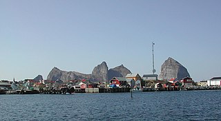
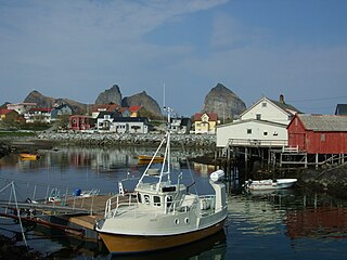
The Solvær islands are a group of islands in the municipality of Lurøy in Nordland county, Norway. They are located between the islands of Lovund to the west and Onøya to the east. The islands are located about a 90-minute ferry ride west of the mainland. Due to the Gulf Stream, the climate is mild, with little snow despite its northern location.

Lurøya is an island in the municipality of Lurøy in Nordland county, Norway. The 14.2-square-kilometre (5.5 sq mi) island is located just west of the island of Stigen and just north of the island of Onøya. Lurøya has a bridge connection to Onøya. The village of Lurøy is located on Lurøya, and that is the administrative centre of the municipality. Lurøy Church is located on the southwest side of the island. The highest point on the island is the 685-metre (2,247 ft) tall mountain Lurøyfjellet. In 2017, there were 138 residents of the island.

Storselsøya is an island in Nordland county, Norway. The island is divided between two municipalities: Rødøy in the north and Lurøy in the south. The island of Nesøya lies to the west, the island of Lurøya lies to the south, and the mainland village of Tonnes lies to the east.
Tranøy or Tranøya may refer to:

Nesna is the administrative centre of Nesna Municipality in Nordland county, Norway. The village is located on a peninsula on the mainland of Norway, along the Nesnakroken strait, just north of the Ranfjorden and south of the Sjona fjord. The Norwegian County Road 17 crosses the Ranfjorden on a ferry which docks in the village before heading north along the coastline. Nesna also has regular ferry connections to the nearby islands of Handnesøya, Hugla, and Tomma.


