Sogn og Fjordane is a county in western Norway, bordering Møre og Romsdal, Oppland, Buskerud, and Hordaland. The county administration is in the village of Hermansverk in Leikanger municipality. The largest town in the county is Førde.

Troms (pronounced [trʊms] or Romsa or Tromssa is a county in northern Norway. It borders Finnmark county to the northeast and Nordland county in the southwest. Norrbotten Län in Sweden is located to the south and further southeast is a shorter border with Lapland Province in Finland. To the west is the Norwegian Sea.

Nesna is a municipality in Nordland county, Norway. It is part of the Helgeland traditional region. The administrative centre of the municipality is the village of Nesna. Other villages in Nesna include Handnesneset, Husby, Saura, and Vikholmen.

The Oslofjord is an inlet in the south-east of Norway, stretching from an imaginary line between the Torbjørnskjær and Færder lighthouses and down to Langesund in the south to Oslo in the north. It is part of the Skagerrak strait, connecting the North Sea and the Kattegat sea area, which leads to the Baltic Sea. The Oslofjord is not a fjord in the geological sense — in Norwegian the term fjord can refer to a wide range of waterways. The bay is divided into the inner and outer Oslofjord at the point of the 17 by 1 kilometre Drøbak Sound.

The Sognefjord or Sognefjorden, nicknamed the King of the Fjords, is the largest and deepest fjord in Norway. Located in Sogn og Fjordane county in Western Norway, it stretches 205 kilometres (127 mi) inland from the ocean to the small village of Skjolden in the municipality of Luster. The fjord takes its name from the traditional district of Sogn, which covers the southern part of the county.

Nordhordland is a traditional district in the western part of Norway. The district consists of the northern portion of Hordaland county, north of the city of Bergen. It includes the municipalities Austrheim, Fedje, Lindås, Masfjorden, Meland, Modalen, Osterøy, Radøy and Vaksdal. The district roughly corresponds to the Nordhordland prosti, a Church of Norway deanery and to the municipalities in the Nordhordland District Court. Historically, the municipality of Gulen in Sogn og Fjordane county to the north was included in the district.

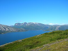
Ofotfjord is a fjord in Nordland county, Norway. It is an inlet of the Norwegian Sea, located about 200 kilometres (120 mi) north of the Arctic Circle. The 78-kilometre (48 mi) long Ofotfjord is Norway's 12th longest fjord and it is also the 18th deepest, with a maximum depth of 553 metres (1,814 ft). In the English language and in many historical documents, this fjord is often referred to as the Narvik Fjord because the town of Narvik is located on the inner shores of the fjord, but this is not an official name of the fjord.

Flostrand is a village in the municipality of Rana in Nordland county, Norway. It is located along Norwegian County Road 17 on the northern bank of the Sjona fjord.
Myklebustad or Myklebostad is a village in the municipality of Rana in Nordland county, Norway. It is located along Norwegian County Road 17 on the southern bank of the Sjona fjord, just west of the villages of Mæla and Utskarpen. Sjona Church is located in the western part of Myklebustad, serving the western part of Rana municipality.
Mæla is a village in the municipality of Rana in Nordland county, Norway. It is located along Norwegian County Road 17 at the eastern end of the Sjona fjord, about 2 kilometres (1.2 mi) north of the villages of Utskarpen and Myklebustad.

Førde Fjord is a fjord in Sogn og Fjordane county, Norway. It is the longest of all the fjords in the traditional district of Sunnfjord. Førdefjorden passes through the municipalities of Førde, Naustdal, Askvoll, and Flora. The fjord begins at the town of Førde, at the estuary of the river Jølstra, which comes from the lake Jølstravatn. The island of Svanøya lies just outside the mouth of Førdefjorden. There are roads along the shoreline on both the north and south sides of the fjord, and the European route E39 highway runs past the town of Førde, near Førdefjorden.

Tomma is an island in the municipality of Nesna in Nordland county, Norway. The 47.3-square-kilometre (18.3 sq mi) island sits to the west of the islands of Handnesøya and Hugla. The island is at the southern entrance to the Sjona fjord. The main settlement on this island is the village of Husby, where the old Husby Estate and the Husby Chapel are located.
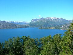
Storfjorden or Storfjord is a 110-kilometre (68 mi) long fjord in the Sunnmøre region of Møre og Romsdal county, Norway. It stretches from the village of Hareid in the west to the villages of Tafjord and Geiranger in the east. The Storfjorden system branches off into several smaller fjords including the famous Geirangerfjord and Tafjorden. At the village of Stranda, the main fjord branches off into the Sunnylvsfjorden-Geirangerfjorden to the west and the Norddalsfjorden-Tafjorden to the east.

Sogn is a traditional district in Western Norway (Vestlandet). It is located in the county of Sogn og Fjordane, surrounding the Sognefjord, the largest/longest fjord in Norway. The district of Sogn consists of the municipalities of Aurland, Balestrand, Hyllestad, Høyanger, Gulen, Leikanger, Luster, Lærdal, Sogndal, Solund, Vik, and Årdal. The district covers 10,675 square kilometres (4,122 sq mi) and contains about 35% of the county's population. The largest urban area in Sogn is the village of Sogndalsfjøra, with 3,455 residents. The second largest urban area is the village Øvre Årdal, with 3,397 people.

Handnesøya is an island in the municipality of Nesna in Nordland county, Norway. The 34.4-square-kilometre (13.3 sq mi) island lies between the islands of Tomma and Hugla and the mainland, along the Sjona fjord. The mountainous island has a very narrow flat area on the east and west sides where the island's residents live. There is a ferry connection from the village of Handnesneset on the southern tip of the island to the village of Nesna on the mainland and to the island of Tomma. Handnesøya Chapel is located in the village of Saura on the western side of the island.

Hugla is an island in the municipality of Nesna in Nordland county, Norway. The 17.9-square-kilometre (6.9 sq mi) island lies south of the islands of Tomma and Handnesøya, west of the mainland of Nesna, east of the island of Løkta, and north of the Ranfjorden. The residents of the island live mostly on the eastern coast, across the fjord from the village of Nesna.

Eidsfjorden is a fjord in Nordland county, Norway. The 25-kilometre (16 mi) long fjord cuts into the island of Langøya in the Vesterålen archipelago and it is located in the municipalities of Bø, Hadsel, and Sortland. It branches off of the main Vesterålsfjorden which is part of Norwegian Sea. The innermost part of the fjord is part of Sortland Municipality. The outer part of the fjord is split with the western coast belonging to Bø Municipality and the eastern coast belonging to Hadsel Municipality.

Vanylvsfjorden is a fjord in western Norway, on the border of Sogn og Fjordane and Møre og Romsdal counties. The 30-kilometre (19 mi) long fjord runs between the mainland of Vanylven Municipality and the Stad peninsula of Selje Municipality, with the islands of Sande Municipality lying in the mouth of the fjord. The inner part of the fjord branches into the Syltefjorden and Kjødepollen. The deepest part of the fjord reaches about 252 metres (827 ft) below sea level, just northeast of Borgundvåg.

Fensfjorden is a fjord on the border of Hordaland and Sogn og Fjordane counties in Norway. The 30-kilometre (19 mi) long fjord begins in the North Sea at Holmengrå Lighthouse and flows to the southeast through the municipalities of Austrheim, Gulen, Lindås, and Masfjorden. The fjord ends on the Masfjorden-Lindås border where it splits into two fjords: Masfjorden and Austfjorden.
Nesna is the administrative centre of Nesna Municipality in Nordland county, Norway. The village is located on a peninsula on the mainland of Norway, along the Nesnakroken strait, just north of the Ranfjorden and south of the Sjona fjord. The Norwegian County Road 17 crosses the Ranfjorden on a ferry which docks in the village before heading north along the coastline. Nesna also has regular ferry connections to the nearby islands of Handnesøya, Hugla, and Tomma.