Related Research Articles

The Arctic Archipelago, also known as the Canadian Arctic Archipelago, is an archipelago lying to the north of the Canadian continental mainland, excluding Greenland and Iceland

Kincardineshire or the County of Kincardine, also known as the Mearns, is a historic county, registration county and lieutenancy area on the coast of north-east Scotland. It is bounded by Aberdeenshire on the north, and by Angus on the south-west.

USS Card was an American Bogue-class escort carrier that saw service in World War II. She was named for Card Sound, a continuation of Biscayne Bay, south of Miami, Florida. She was the flagship of Task Group 21.14, a hunter-killer group formed to destroy German submarines in the North Atlantic.
Hope Bay is a bay 3 nautical miles long and 2 nautical miles wide, indenting the tip of the Antarctic Peninsula and opening on Antarctic Sound.

Ury House is a large ruined mansion in Aberdeenshire, Scotland, built in the Elizabethan style in 1885 by Sir Alexander Baird, 1st Baronet. It is situated on the north-east coast about 1 mile (1.6 km) north of Stonehaven in the former county of Kincardineshire.

Glenbervie is located in the north east of Scotland in the Howe o' the Mearns, one mile from the village of Drumlithie and eight miles south of Stonehaven in Aberdeenshire. The river Bervie runs through the village. The rural area is the location of Glenbervie House and estate. The parish was formerly named Overbervie.
The Fetteresso Forest is a woodland that is principally coniferous situated in the Mounth range of the Grampian Mountains in Aberdeenshire, Scotland. The forest has a number of prominent mountain peaks including the Hill of Blacklodge and Craiginour peak. A good overlook for viewing the forest from the north side lies on an unnamed tarmack road which leads north from the Slug Road to the Raedykes Roman site. The Cowie Water flows through and drains much of the forest. To the north of the easternmost part of the forest is the archaeological site Raedykes Roman Camp, as well as Cowton Burn. The Slug Road runs along much of the northeast perimeter of Fetteresso Forest.
Megray Hill is a low-lying coastal mountainous landform in Aberdeenshire, Scotland within the Mounth Range of the Grampian Mountains. The peak elevation of this mountain is 120 metres above mean sea level. This hill has been posited as a likely location for the noted Battle of Mons Graupius between the Romans and the indigenous Caledonians. The major Roman Camp of Raedykes is situated about three kilometres to the west. From Megray Hill there are expansive views to the North Sea facing east. The summit affords scenic views of the historic harbour of Stonehaven.

The Chapel of St. Mary and St. Nathalan is a ruined chapel overlooking the North Sea immediately north of Stonehaven, in the Mearns of Scotland, along the northern shoreline of Stonehaven Bay. The founding of this Christian place of worship is associated with St. Nathalan. who lived circa 650 AD. The structure is alternatively known as Cowie Chapel. The chapel is at the point where the Highland Boundary Fault meets the sea and so is on the dividing line between the highlands and lowlands of Scotland.

Cowie Bridge is a roadway bridge which carries the B979 across the mouth of the Cowie Water in Stonehaven, Aberdeenshire, Scotland.

The Kirktown of Fetteresso is a well-preserved village near Stonehaven, Scotland. In the planning area of Kincardine and Mearns, Aberdeenshire, this village contains many very old stone residential structures as well as the Church of St. Ciarans and its associated graveyard. The Carron Water winds through the Kirktown of Fetteresso, and Fetteresso Castle, a listed building, lies at the northwestern verge. Some of the earliest area prehistory has been found nearby on the Fetteresso Estate grounds, where there have been archaeological finds from the Bronze Age.

Bowdun Head is a headland landform on the North Sea coast approximately one kilometre south of Stonehaven, Scotland.(Ordnance Survey, 2004) Slightly to the north is another headland, Downie Point. Somewhat to the south along the coast is Dunnottar Castle on the far side of the bay of Castle Haven. Other historic structures in the general vicinity include the Stonehaven Tolbooth, Fetteresso Castle, the Chapel of St. Mary and St. Nathalan and Muchalls Castle. There is considerable prehistory associated with the local area including a Pictish hill fort on the sea stack of Dunnicaer immediately to the north, and Bronze Age archaeological sites at Fetteresso and Spurryhillock, both somewhat inland of Bowdun Head.

Rickarton House is a 19th-century country house in Kincardineshire, Scotland. It lies approximately three-and-a-half miles northwest of Stonehaven in the former county of Kincardineshire. The house is situated on the north banks of the Cowie Water slightly upstream of the confluence with Cowton Burn. Rickarton is a category B listed building. Rickarton House was constructed in the first decade of the 19th century for William Rickart Hepburn. He commissioned the City Architect of Aberdeen, John Smith, to undertake the work.

Downie Point is a prominent headland located at the southern edge of Stonehaven Bay in Aberdeenshire, Scotland. From the Stonehaven Harbour, there is a panoramic view of this cliff landform, especially from the tip of Bellman's Head.
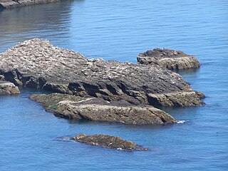
Craiglethy is a small island/skerry off Fowlsheugh on the east coast of Aberdeenshire, Scotland in the North Sea. As it is part of Fowlsheugh, it is an SSSI, with many seabirds and seals living on it. It is also one of the few islands on the east coast of Scotland, along with Mugdrum Island and Inchcape, apart from the Islands of the Forth.
Thornyhive Bay is an embayment along the North Sea coast in Aberdeenshire, Scotland. This bay is situated approximately 2.5 miles south of the town of Stonehaven and approximately 2.5 miles north of the Fowlsheugh Nature Reserve. The steep cliffs afford sightings of certain seabirds.

Largo Bay is a bay on the northern shore of the Firth of Forth, on the coast of Fife, Scotland.
Nunatarsuaq is a nunatak in Avannaata municipality in northwestern Greenland.
Strathlethan Bay is on the North Sea coast of Aberdeenshire, Scotland just south of Stonehaven. To the north is Downie Point near which lies Stonehaven's Black Hill war memorial – the popular walk from Stonehaven to Dunnottar Castle runs along this part of the trail. On the other side of the bay is Dunnicaer, an inaccessible sea stack just offshore of Bowdun Head. The long-distance Aberdeenshire Coastal Trail runs around the bay at the top of steep cliffs. On 19 November 1916 the wreckage of the Norwegian steamer Isa Fiord was washed ashore in the bay and on 8 October 1940 the Danish ship Bellona II came aground after it had suffered bombing damage off Gourdon.

The Stonehaven derailment was a fatal railway accident that occurred at 09:38 BST on 12 August 2020, when a passenger train returning to Aberdeen hit a landslip, near Carmont, west of Stonehaven in Aberdeenshire, Scotland, following severe rain. Of the nine people aboard, three were killed, and six were injured.
References
56°58′N2°12′W / 56.967°N 2.200°W
| | This Aberdeenshire location article is a stub. You can help Wikipedia by expanding it. |