
Oxfordshire is a ceremonial county in South East England. The county is bordered by Northamptonshire and Warwickshire to the north, Buckinghamshire to the east, Berkshire to the south, and Wiltshire and Gloucestershire to the west. The city of Oxford is the largest settlement and county town.
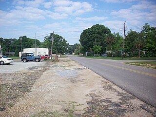
Napier Field is a town in Dale County, Alabama. At the 2020 census, the population was 409. It is part of the Ozark micropolitan statistical area. The town was originally constructed as a military air base during the Second World War. It is currently adjacent to Dothan Regional Airport. While the airport itself lies within Dothan's city limits, the adjacent housing units and other buildings constitute the incorporated town of Napier Field.

Stratford-on-Avon is a local government district in Warwickshire, England. The district is named after its largest town of Stratford-upon-Avon, but with a change of preposition; the town uses "upon" and the district uses "on". The council is based in Stratford-upon-Avon and the district, which is predominantly rural, also includes the towns of Alcester, Shipston-on-Stour and Southam, and the large villages of Bidford-on-Avon, Studley and Wellesbourne, plus numerous other smaller villages and hamlets and surrounding rural areas. The district covers the more sparsely populated southern part of Warwickshire, and contains nearly half the county's area. The district includes part of the Cotswolds, a designated Area of Outstanding Natural Beauty.
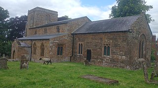
Wormleighton is a village in Warwickshire, England. It sits on Wormleighton Hill overlooking the River Cherwell. The population taken at the 2011 census was 183.
Wightwick is a part of Tettenhall Wightwick ward in Wolverhampton, West Midlands, England. It is named after an ancient local family the "de Wightwicks". It is on the western fringe of Wolverhampton and borders the rural South Staffordshire area that includes neighbourhoods such as Perton.
Southam Rural District was a rural district in the county of Warwickshire, England. It was created in 1894 and consisted of 26 parishes, a further six parishes were added in 1932, when the Farnborough Rural District was disbanded. It was named after and administered from Southam.

Toddington is a large village and civil parish in the county of Bedfordshire, England. It is situated 5 miles north-north-west of Luton, 4 miles (6 km) north of Dunstable, 6 miles (10 km) south-west of Woburn, and 35 miles north-north-west of London on the B5120 and B579. It is 0.5 miles from Junction 12 of the M1 motorway and lends its name to the nearby motorway service station. The hamlet of Fancott also forms part of the Toddington civil parish.
Lapworth is a village and civil parish in Warwickshire, England, which had a population of 2,100 according to the 2001 census; this had fallen to 1,828 at the 2011 Census. It lies seven miles (11 km) south of Solihull and ten miles (16 km) northwest of Warwick, and incorporates the hamlet of Kingswood. Lapworth boasts a historic church, the Church of St Mary the Virgin, a chapel. Two National Trust sites are nearby: Baddesley Clinton, a medieval moated manor house and garden located in the village of Baddesley Clinton; and Packwood House, a Tudor manor house and yew garden with over 100 trees in Packwood.

Cheswick Green is a village and civil parish within the Metropolitan Borough of Solihull in the English county of West Midlands, incorporating the nearby hamlet of Illshaw Heath. The settlement lies approximately 3 miles (4.8 km) south west of Solihull town centre. The civil parish population as taken at the 2011 census was 2,197. It borders Dickens Heath and Monkspath to the north, and Earlswood and Warings Green to the south. The northernmost part of Warings Green lies in the parish of Cheswick Green.

Chelveston is a small village in North Northamptonshire. It is about 2 miles (3.2 km) east of Higham Ferrers and 7 miles (11.3 km) east of Wellingborough on the B645 from Higham Ferrers to St Neots. To the south is the hamlet of Caldecott and the settlement of Chelston Rise which together comprise the civil parish of Chelveston cum Caldecott. The population is now included in the civil parish of Chelveston cum Caldecott.

Norton Bridge railway station was a railway station located on the West Coast Main Line and served both the village of Norton Bridge and the town of Eccleshall in Staffordshire, England.
Rowington is a village and civil parish in the English county of Warwickshire. It is five miles north-west of the town of Warwick and five miles south-west of the town of Kenilworth. The parish, which also includes Lowsonford, Pinley and Mousley End, had a population of 925 according to the 2001 UK Census, increasing to 944 at the 2011 Census. The Grand Union Canal runs just south of the village and the M40 motorway is also close by. The Heart of England Way for long-distance walkers passes through the village. The parish church of St. Laurence which dates from medieval times is found on a hill in the centre of the village. In the Tudor era Rowington manor was owned by Queen Catherine Parr.
Hinwick House is a Grade I-listed Queen Anne country house located about 90 minutes from Central London, near Podington in North Bedfordshire. The estate consists of the Queen Anne main house, the Victorian wing, the Victorian wing extension, garage block, stables, three cottages attached to a clock tower, a walled garden and a period dovecote. The house and estate has a total of 50 rooms. Hinwick House underwent a two-year restoration programme that concluded in 2016.

Bayble Island lies at the southern end of Bayble Bay. It consists of two islands, but these appear as a single island from most directions. The hamlets of Upper and Lower Bayble overlook the island and bay.

The Augustine Band of Cahuilla Indians is a federally recognized Cahuilla band of Native Americans based in Coachella, California. They are one of the smallest tribal nations in the United States, consisting of only 16 members, seven of whom are adults.

Highlander is situated between the 5th and 6th Milestone road-side markers on the Snaefell Mountain Course used for the Isle of Man TT races on the primary A1 Douglas to Peel road in the parish of Marown in the Isle of Man.

Fred Hayes State Park at Starvation is a state park in Duchesne County, Utah, United States, featuring the 3,495-acre (1,414 ha) Starvation Reservoir. The park is 4 miles (6.4 km) northwest of the city of Duchesne.

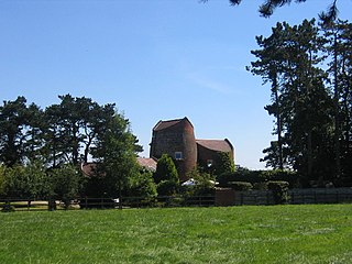
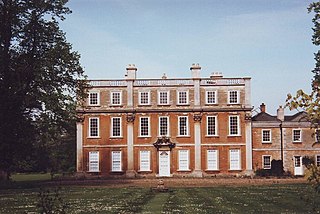
Wormleighton Manor is a manor house in the civil parish of Wormleighton in the historic county of Warwickshire, England. It belonged to the wealthy Spencer family during the 16th and 17th century. Much of the house was burned down by Royalists during the English Civil War in 1645 and abandoned by the Spencers in favour of Althorp in Northamptonshire, which contains some materials salvaged from Wormleighton to this day. Today, all that is left of the manor, which was once four times the size of Althorp, is the Wormleighton Manor Gatehouse and Tower Cottage which is a Grade II listed building, and the northern range of the manor.
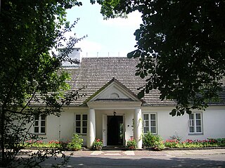
The Birthplace of Frédéric Chopin is a "dworek" surrounded by a large natural park at the banks of Utrata River in Żelazowa Wola near Sochaczew in Poland – presently museum of the composer, department of the Fryderyk Chopin Museum in Warsaw.
Kern Island Canal is an irrigation canal in Kern County, California. It primarily irrigates farmland located on the Kern Lakebed, south of Bakersfield. It originates from a common diversion at Manor Street in Bakersfield, which also supplies the Carrier Canal and Eastside Canal. The common diversion originates from the Kern River about 1 mile (1.6 km) south of Gordon's Ferry.
