
Traffic comprises pedestrians, vehicles, ridden or herded animals, trains, and other conveyances that use public ways (roads/sidewalks) for travel and transportation.

A roundabout, a rotary and a traffic circle are all, with certain distinctions between them, a type of circular intersection or junction in which road traffic is permitted to flow in one direction around a central island, and priority is typically given to traffic already in the junction.

An intersection or an at-grade junction is a junction where two or more roads converge, diverge, meet or cross at the same height, as opposed to an interchange, which uses bridges or tunnels to separate different roads. Major intersections are often delineated by gores and may be classified by road segments, traffic controls and lane design.

A pedestrian crossing is a place designated for pedestrians to cross a road, street or avenue. The term "pedestrian crossing" is also used in the Vienna and Geneva Conventions, both of which pertain to road signs and road traffic.

Traffic lights, traffic signals, or stoplights – also known as robots in South Africa and Namibia – are signalling devices positioned at road intersections, pedestrian crossings, and other locations in order to control the flow of traffic.
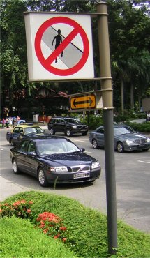
Jaywalking is the act of pedestrians walking in or crossing a roadway if that act contravenes traffic regulations. The term originated in the United States as a derivation of the phrase jay-drivers, people who drove horse-drawn carriages and automobiles on the wrong side of the road, before taking its current meaning. Jaywalking was coined as the automobile arrived in the street in the context of the conflict between pedestrian and automobiles, more specifically the nascent automobile industry.
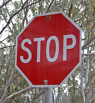
A stop sign is a traffic sign designed to notify drivers that they must come to a complete stop and make sure the intersection is safely clear of vehicles and pedestrians before continuing past the sign. In many countries, the sign is a red octagon with the word STOP, in either English or the national language of that particular country, displayed in white or yellow. The Vienna Convention on Road Signs and Signals also allows an alternative version: a red circle with a red inverted triangle with either a white or yellow background, and a black or dark blue STOP. Some countries may also use other types, such as Japan's inverted red triangle stop sign. Particular regulations regarding appearance, installation, and compliance with the signs vary by some jurisdictions.

Road surface marking is any kind of device or material that is used on a road surface in order to convey official information; they are commonly placed with road marking machines. They can also be applied in other facilities used by vehicles to mark parking spaces or designate areas for other uses. In some countries and areas, road markings are conceived as horizontal traffic signs, as opposed to vertical traffic signs placed on posts.

An advanced stop line (ASL), also called advanced stop box or bike box, is a type of road marking at signalised road junctions allowing certain types of vehicle a head start when the traffic signal changes from red to green. Advanced stop lines are implemented widely in Denmark, the United Kingdom, and other European countries but the idea was first conceptualized by transportation planner Michael Lynch for the city of Portland, Oregon, in response to numerous bike crashes at intersections.
For driving in the United States, each state and territory has its own traffic code or rules of the road, although most of the rules of the road are similar for the purpose of uniformity, given that all states grant reciprocal driving privileges to each other's licensed drivers. There is also a "Uniform Vehicle Code" which was proposed by a private, non-profit group, based upon input by its members. The UVC was not adopted in its entirety by any state. As with uniform acts in general, some states adopted selected sections as written or with modifications, while others created their own sui generis statutes touching upon the same subject matter. As required by the federal Highway Safety Act of 1966, all states and territories have adopted substantially similar standards for the vast majority of signs, signals, and road surface markings, based upon the Manual on Uniform Traffic Control Devices from the U.S. Department of Transportation. Many of the standard rules of the road involve consistent interpretation of the standard signs, signals, and markings such as what to do when approaching a stop sign, or the driving requirements imposed by a double yellow line on the street or highway. In order to implement their own traffic laws on the property of their own facilities, several federal agencies have also developed their own traffic laws.

In traffic engineering, there are regional and national variations in traffic light operation. This may be in the standard traffic light sequence or by the use of special signals.

An all-way stop – also known as a four-way stop – is a traffic management system which requires vehicles on all the approaches to a road intersection to stop at the intersection before proceeding through it. Designed for use at low traffic-volume locations, the arrangement is common in the United States, Canada, Mexico, South Africa, and Liberia, as well as in a number of, usually rural, locations in Australia where visibility on the junction approaches is particularly poor. The stop signs at such intersections may be supplemented with additional plates stating the number of approaches.

A HAWK beacon is a traffic control device used to stop road traffic and allow pedestrians to cross safely. It is officially known as a pedestrian hybrid beacon. The purpose of a HAWK beacon is to allow protected pedestrian crossings, stopping vehicular traffic only as needed. The HAWK beacon is a type of traffic control alternative to traffic control signals and/or where an intersection does not meet traffic signal warrants.

In the United States, road signs are, for the most part, standardized by federal regulations, most notably in the Manual on Uniform Traffic Control Devices (MUTCD) and its companion volume the Standard Highway Signs (SHS).

In Japan, road signs are standardized by the "Order on Road Sign, Road Line, and Road Surface Marking (道路標識、区画線及び道路標示に関する命令)" established in 1968 with origins from the Tokyo Metropolitan Police Department's "Order on Standardization of Road Sign" of 1934 and the Home Ministry of Japan's "Order on Road Signs" of 1942. The previous designs have been used since 1986 after several amendments of order.
Road traffic control devices are markers, signs and signal devices used to inform, guide and control traffic, including pedestrians, motor vehicle drivers and bicyclists. These devices are usually placed adjacent, over or along the highways, roads, traffic facilities and other public areas that require traffic control.
Road signs in Canada may conform to the Manual of Uniform Traffic Control Devices for Canada (MUTCDC) by the Transportation Association of Canada (TAC) for use by Canadian jurisdictions. Although it serves a similar role to the MUTCD from the US Federal Highway Administration, it has been independently developed and has a number of key differences with its American counterpart, most notably the inclusion of bilingual (English/French) signage for jurisdictions such as New Brunswick with significant anglophone and francophone population, and a heavier reliance on symbols rather than text legends.

Terminology related to road transport—the transport of passengers or goods on paved routes between places—is diverse, with variation between dialects of English. There may also be regional differences within a single country, and some terms differ based on the side of the road traffic drives on. This glossary is an alphabetical listing of road transport terms.

Crosswalks in the United States and Canada are normally found at intersections, though sometimes may be found mid-block. Crosswalk installations must follow the regulations specified in the Manual on Uniform Traffic Control Devices (MUTCD). At signalized intersections, crosswalks may have pedestrian signals which display symbols to mandate when pedestrians may cross the street.
Road signs in Puerto Rico are regulated in the Manual de Rotulación para las Vías Públicas de Puerto Rico, Puerto Rico’s supplement to the Manual on Uniform Traffic Control Devices (MUTCD), the standard for road signs, signals, and markings in the United States. It is developed by the Puerto Rico Highways and Transportation Authority (PRHTA) "in substantial conformance to" the national MUTCD developed by the Federal Highway Administration.


