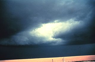
A tornado is a violently rotating column of air that is in contact with both the surface of the Earth and a cumulonimbus cloud or, in rare cases, the base of a cumulus cloud. It is often referred to as a twister, whirlwind or cyclone, although the word cyclone is used in meteorology to name a weather system with a low-pressure area in the center around which, from an observer looking down toward the surface of the Earth, winds blow counterclockwise in the Northern Hemisphere and clockwise in the Southern. Tornadoes come in many shapes and sizes, and they are often visible in the form of a condensation funnel originating from the base of a cumulonimbus cloud, with a cloud of rotating debris and dust beneath it. Most tornadoes have wind speeds less than 180 kilometers per hour, are about 80 meters across, and travel several kilometers before dissipating. The most extreme tornadoes can attain wind speeds of more than 480 kilometers per hour (300 mph), are more than 3 kilometers (2 mi) in diameter, and stay on the ground for more than 100 km (62 mi).

Skywarn is a program of the National Weather Service (NWS). Its mission is to collect reports of localized severe weather in the United States. These reports are used to aid forecasters in issuing and verifying severe weather watches and warnings and to improve the forecasting and warning processes and the tools used to collect meteorological data. Reports are also used by local emergency managers and public safety organizations.

A tornado warning is a public warning that is issued by weather forecasting agencies to an area in the direct path of a tornado or a thunderstorm that is capable of producing a tornado. Modern weather surveillance technology such as Doppler weather radar allow for early detection of rotation in a thunderstorm, and for subsequent warnings to be issued before a tornado actually develops. It is nevertheless still not uncommon that warnings are issued based on reported visual sighting of a tornado, funnel cloud, or wall cloud, typically from weather spotters or the public, but also law enforcement or local emergency management. In particular, a tornado can develop in a gap of radar coverage, of which there are several known in the United States.

A tornado watch is a severe weather watch product of the National Weather Service that is issued by national weather forecasting agencies when meteorological conditions are favorable for the development of severe thunderstorms capable of producing tornadoes. In addition to the potential for tornado development, thunderstorms that develop within the watch area may contain large hail, straight-line winds, intense rainfall and/or flooding that pose a similar damage risk as the attendant tornado threat. A tornado watch does not mean a tornado is active or will appear, just that favorable conditions increases the likelihood of such happening. A watch must not be confused with a tornado warning.

A severe thunderstorm warning is a type of public warning for severe weather that is issued by weather forecasting agencies worldwide when one or more severe thunderstorms have been detected by Doppler weather radar, observed by weather spotters, or reported by an emergency management agency, law enforcement, or the general public. Unlike a watch, a warning is issued to areas in the direct path of active severe thunderstorms, that are expecting a direct impact typically within an hour. Severe thunderstorms can cause property damage and injury due to large hail, high winds, and flooding due to torrential rainfall. The exact criteria to issue a warning varies from country to country.

The National Weather Service (NWS) is an agency of the United States federal government that is tasked with providing weather forecasts, warnings of hazardous weather, and other weather-related products to organizations and the public for the purposes of protection, safety, and general information. It is a part of the National Oceanic and Atmospheric Administration (NOAA) branch of the Department of Commerce, and is headquartered in Silver Spring, Maryland, within the Washington metropolitan area. The agency was known as the United States Weather Bureau from 1890 until it adopted its current name in 1970.

Storm chasing is broadly defined as the deliberate pursuit of any severe weather phenomenon, regardless of motive, but most commonly for curiosity, adventure, scientific investigation, or for news or media coverage. A person who chases storms is known as a storm chaser or simply a chaser.
This article describes severe weather terminology used by the National Weather Service (NWS) in the United States. The NWS, a government agency operating as an arm of the National Oceanic and Atmospheric Administration (NOAA) branch of the United States Department of Commerce (DoC), defines precise meanings for nearly all of its weather terms.
Weather spotting is observing weather for the purpose of reporting to a larger group or organization. Examples include National Weather Service (NWS) co-op observers and Skywarn storm spotters.
A Local Storm Report (LSR) is transmitted by the National Weather Service (NWS) when it receives significant information from storm spotters, such as amateur radio operators, storm chasers, law enforcement officials, civil defense personnel, firefighters, EMTs or public citizens, about severe weather conditions in their warning responsibility area. Those reports are received by local National Weather Service offices (WFOs), and they can be used to issue Severe Thunderstorm Warnings, Tornado Warnings, and other weather warnings/bulletins, in addition to the LSR.
A tornado emergency is an enhanced version of a tornado warning, which is used by the National Weather Service (NWS) in the United States during imminent, significant tornado occurrences in highly populated areas. Although it is not a new warning type from the NWS, issued instead within a severe weather statement or in the initial tornado warning, a tornado emergency generally means that significant, widespread damage is expected to occur and a high likelihood of numerous fatalities is expected with a large, strong to violent tornado.
A significant weather advisory was a hazardous weather statement issued by certain Weather Forecast Offices (WFO) of the National Weather Service (NWS) in the United States to alert the public of thunderstorm activity that is below designated severe criteria for and/or is not expected to produce severe weather. The title assigned to the advisory — alternately titled "significant weather alert" or referenced by its originating product, "special weather statement" — varied by the issuing WFO.
Convective storm detection is the meteorological observation, and short-term prediction, of deep moist convection (DMC). DMC describes atmospheric conditions producing single or clusters of large vertical extension clouds ranging from cumulus congestus to cumulonimbus, the latter producing thunderstorms associated with lightning and thunder. Those two types of clouds can produce severe weather at the surface and aloft.
Storm spotting is a form of weather spotting in which observers watch for the approach of severe weather, monitor its development and progression, and actively relay their findings to local authorities.

From April 13 to 16, 2012, a major tornado outbreak occurred across a large portion of the Great Plains. The storms resulted in six tornado-related fatalities, all of which occurred as a result of a nighttime EF3 tornado that caused major damage in and around Woodward, Oklahoma. Numerous other tornadoes occurred, including a violent EF4 tornado that passed near Marquette, Kansas, and an EF3 that caused major damage in Wichita.
The Spotter Network (SN) is a system that utilizes storm spotter and chaser reports of location and severe weather in a centralized framework for use by coordinators such as emergency managers, Skywarn and related spotter organizations, and the National Weather Service. It uses GPS to provide accurate and automated position data of storm spotters and chasers for coordination and reporting, which in turn provides ground truth to public servants engaged in the protection of life and property. The network is a combination of locally installed software for position and status reporting and web-based processing, mapping, and reporting.

National Weather Service - Norman, Oklahoma is a Weather Forecast Office (WFO) of the National Weather Service based in Norman, Oklahoma, which is responsible for forecasts and the dissemination of weather warnings and advisories for central and most of western Oklahoma, and western portions of north Texas. It is located in the National Weather Center on the University of Oklahoma campus, where it acts as one of the NOAA Weather Partners, a group of close-together weather-related agencies of the National Oceanic and Atmospheric Administration. NWS Norman is currently overseen by Mark Fox, who serves as the Meteorologist In Charge of the office.
The following is a glossary of tornado terms. It includes scientific as well as selected informal terminology.
A hurricane local statement (HLS) is a weather statement produced for the public by the local Weather Forecast Offices of the National Weather Service in the U.S. for areas affected or forecast to be affected by a tropical storm or hurricane that provides an overview of the storm's local effects, including expected weather conditions, evacuation decisions made by local officials, and precautions necessary to protect life and property. The National Weather Services considers the HLS to be the "flagship product" available to Weather Forecast Offices for outlining tropical cyclone watches and warnings and impacts, and is their most visible product during such events. Descriptions of the affected areas, relevant tropical cyclone watches and warnings, recommendations for precautionary measures, and expected timing and severity of possible threats are typically included in an HLS. The HLS can incorporate projected impacts from pre-written descriptions tailored for different storm intensities; these template descriptions were developed in the 1990s and became widely available to forecasters for use in the HLS by 2001. The bulletin issued by the Weather Forecast Office in Slidell, Louisiana, as Hurricane Katrina approached on August 28, 2005, known as "The Bulletin", was lauded by the National Weather Service as having further encouraged vulnerable individuals to evacuate. Not all forecast offices can issue an HLS.

Alan Roger Moller was an American meteorologist, storm chaser, nature and landscape photographer known for advancing spotter training and bridging operational meteorology with research.


