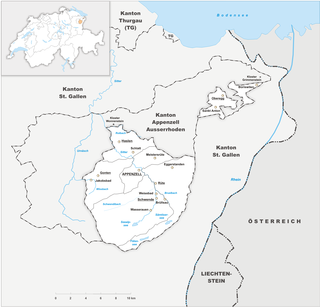
Appenzell Innerrhoden is one of the 26 cantons forming the Swiss Confederation. It is composed of six districts. The seat of the government and parliament is Appenzell. It is traditionally considered a "half-canton", the other half being Appenzell Ausserrhoden.

Appenzell Ausserrhoden is one of the 26 cantons forming the Swiss Confederation. It is composed of twenty municipalities. The seat of the government and parliament is Herisau, and the seat of judicial authorities are in Trogen. It is traditionally considered a "half-canton", the other half being Appenzell Innerrhoden.

Urnäsch is a municipality in the canton of Appenzell Ausserrhoden, Switzerland.
Gais is a village and a municipality in the canton of Appenzell Ausserrhoden in Switzerland. The area of Gais is 21.21 km2 (8.19 sq mi).

Appenzell is a historic canton in the northeast of Switzerland, and entirely surrounded by the canton of St. Gallen.

Appenzell District is a district of the canton of Appenzell Innerrhoden in Switzerland. It has a population of 5,793. The area of Appenzell is 16.88 km2 (7 sq mi). The district of Appenzell consists of a part of the village Appenzell, as well as Rinkenbach, Kau and Meistersrüte.

In glaciology, a roche moutonnée is a rock formation created by the passing of a glacier. The passage of glacial ice over underlying bedrock often results in asymmetric erosional forms as a result of abrasion on the "stoss" (upstream) side of the rock and plucking on the "lee" (downstream) side. These erosional features are seen on scales of less than a metre to several hundred metres.

Ruppen Pass is a high mountain pass between the cantons of St. Gallen and Appenzell Ausserrhoden in Switzerland.
Schwägalp Pass is a high mountain pass in the Alps between the cantons of St. Gallen and Appenzell Ausserrhoden in Switzerland.

St. Anton Pass is a high mountain pass in the Alps between the cantons of Appenzell Innerrhoden and St. Gallen in Switzerland.

The Hoher Kasten is a mountain in the Appenzell Alps, overlooking the Rhine in Eastern Switzerland. It is located on the border between the cantons of Appenzell Innerrhoden and St. Gallen.
The Appenzell Wars were a series of conflicts that lasted from 1401 until 1429 in the Appenzell region of Switzerland. The wars were a successful uprising of cooperative groups, such as the farmers of Appenzell or the craftsmen of the city of St. Gallen, against the traditional medieval power structure represented by the House of Habsburg and the Prince-Abbot of the Abbey of St. Gall.

Vogtei Rheintal was a condominium of the Old Swiss Confederacy from the 15th century until 1798. Its territory corresponded to the left banks of the Alpine Rhine between Hoher Kasten and Lake Constance, including the towns of Altstätten and Rheineck.
The Grenzchopf is a mountain of the Appenzell Alps, overlooking the Schwägalp Pass on the border between the Swiss cantons of Appenzell Ausserrhoden and St. Gallen.

The Hundwiler Höhi is a mountain of the Appenzell Alps, located on the border between the Swiss cantons of Appenzell Ausserrhoden and Appenzell Innerrhoden. It is situated between Hundwil and Gonten.

The Schwyz Alps are a mountain range in Switzerland. They form part of the North-Eastern Swiss Alps and are bordered by the Glarus Alps to the east, the Appenzell Alps to the north-east, the Emmental Alps in the west, and the Uri Alps to the south-west. The Klausen Pass is the highest point between the Schwyz Alps and the Glarus Alps.

The Appenzell–St. Gallen–Trogen railway, also known as the Durchmesserlinie, is a metre gauge overland tramway in the Swiss cantons of Appenzell Innerrhoden and Ausserrhoden and the city of St. Gallen. It is the steepest adhesion railway in Switzerland with a gradient of up to 8.0% and forms part of the network of the Appenzell Railways (AB) and the St. Gallen S-Bahn. The line's two branches were completed in sections between 1889 and 1904 by the St. Gallen-Gais-Appenzell-Altstätten Railway and the Trogen Railway. The two lines were connected by the AB with a cross-city route in 2018.

The Altstätten–Gais railway is a metre-gauge in Switzerland. The 7.65 kilometre-long line was opened in 1911 by the Altstätten-Gais-Bahn (AG) and has been operated by the Appenzell Railways. Three sections of the line are equipped with rack under the strub system.

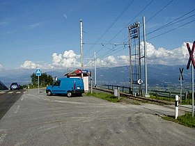
Stoss railway station is a railway station in Gais, in the Swiss canton of Appenzell Ausserrhoden. It is an intermediate stop on the 1,000 mmmetre gauge Altstätten–Gais line and is served by local trains only.