
Strathkelvin Railway Path is rail trail following the route of several dismantled railway lines extending from Gartcosh to Strathblane. It goes for 10 km from one end to another
Strathkelvin Railway Path is rail trail following the route of several dismantled railway lines extending from Gartcosh to Strathblane. It goes for 10 km from one end to another
The northern section follows the route of the Campsie Branch of the Edinburgh and Glasgow Railway which was extended as the Blane Valley Railway line and closed in 1951 (although some parts of the line were still used for freight into the '60s). [1] The southern section follows a branch of the Monkland and Kirkintilloch Railway. Starting in Kirkintilloch it runs south and currently terminates at the northern tip of Gartcosh; just before the original railway junction would have split east to Bedlay Colliery and south to Glenboig.
It has been announced by Sustrans that the path will become part of the National Cycle Network and called route 755. In the future it is planned that the path will be extended to the north further following the route of the dismantled railway to incorporate part of the West Highland Way towards Drymen where it will link to National Cycle Network no. 754 (Forth & Clyde Canal) and National Cycle Network no. 7. To the south there are plans to continue the path to Drumpellier Country Park and then the Monkland Canal where it will link to National Cycle Network no. 75 in Coatbridge. [2]

The National Cycle Network (NCN) was established to encourage cycling and walking throughout the United Kingdom, as well as for the purposes of bicycle touring. It was created by the charity Sustrans who were aided by a £42.5 million National Lottery grant. However Sustrans themselves only own around 2% of the paths on the network, the rest being made of existing public highways and rights of way, and permissive paths negotiated by Sustrans with private landowners.

The Caledonian Railway (CR) was a major Scottish railway company. It was formed in the early 19th century with the objective of forming a link between English railways and Glasgow. It progressively extended its network and reached Edinburgh and Aberdeen, with a dense network of branch lines in the area surrounding Glasgow. It was absorbed into the London, Midland and Scottish Railway in 1923. Many of its principal routes are still used, and the original main line between Carlisle and Glasgow is in use as part of the West Coast Main Line railway.

The Monkland Canal was a 12+1⁄4-mile-long (19.7 km) canal designed to bring coal from the mining areas of Monklands to Glasgow in Scotland. In the course of a long and difficult construction process, it was opened progressively as short sections were completed, from 1771. It reached Gartcraig in 1782, and in 1794 it reached its full originally planned extent, from pits at Calderbank to a basin at Townhead in Glasgow; at first this was in two sections with a 96-foot (29 m) vertical interval between them at Blackhill; coal was unloaded and carted to the lower section and loaded onto a fresh barge. Locks were later constructed linking the two sections, and the canal was also connected to the Forth and Clyde Canal, giving additional business potential.
The Edinburgh and Glasgow Railway was authorised by act of Parliament on 4 July 1838. It was opened to passenger traffic on 21 February 1842, between its Glasgow Queen Street railway station and Haymarket railway station in Edinburgh. Construction cost £1,200,000 for 46 miles (74 km). The intermediate stations were at Corstorphine, Gogar, Ratho, Winchburgh, Linlithgow, Polmont, Falkirk, Castlecary, Croy, Kirkintilloch and Bishopbriggs. There was a ticket platform at Cowlairs. The line was extended eastwards from Haymarket to North Bridge in 1846, and a joint station for connection with the North British Railway was opened on what is now Edinburgh Waverley railway station in 1847.

Lenzie railway station is a railway station serving Lenzie and Kirkintilloch in East Dunbartonshire, Scotland. It is located on the Croy Line, 6+1⁄4 miles (10.1 km) northeast of Glasgow Queen Street. Trains on the Glasgow to Edinburgh via Falkirk Line pass Lenzie by. The station is served by ScotRail.
The Edinburgh–Bathgate line is a railway line in East Central Scotland. It is also known as the Bathgate branch and was originally operated by the Edinburgh and Bathgate Railway. Except for the short section at the original Bathgate terminus, the main line is still in use, with a frequent passenger train service operated by ScotRail.

The Forth and Clyde canal pathway runs between the Firth of Forth and the Firth of Clyde and is a 106-kilometre-long (66 mi) footpath and cycleway that runs across Scotland, between Bowling, west of Glasgow, and Lochrin Basin in Edinburgh. The path runs on the towpaths of the Forth & Clyde and Union Canals and is entirely off-road. The path is well maintained and its surface is generally good, although there are some stretches particularly between Falkirk and the outskirts of Edinburgh where wet weather leads to muddy conditions unsuitable for road intended bicycles. It is well used by walkers and cyclists, and designated as one of Scotland's Great Trails by NatureScot. It also forms part of the National Cycle Network, being designated as Route 754. Sustrans advises that the path is best followed from the Clyde to the Forth because the prevailing wind is from the south west. Much of the path is also suitable for experienced horseriders, although in some places low bridges, narrow aqueducts and gates may restrict access for horses.

The Garnkirk and Glasgow Railway was an early railway built primarily to carry coal to Glasgow and other markets from the Monkland coalfields, shortening the journey and bypassing the monopolistic charges of the Monkland Canal; passenger traffic also developed early in the line's existence.
The Ballochney Railway was an early railway built near Airdrie, North Lanarkshire, Scotland. It was intended primarily to carry minerals from coal and ironstone pits, and stone quarries, in the area immediately north and east of Airdrie, to market, predominantly over the adjoining Monkland and Kirkintilloch Railway. Passengers were carried later.
The Slamannan Railway was an early mineral railway between the north-eastern margin of Airdrie and Causewayend on the Union Canal, near Linlithgow, Scotland.
The Monkland and Kirkintilloch Railway was an early mineral railway running from a colliery at Monklands to the Forth and Clyde Canal at Kirkintilloch, Scotland. It was the first railway to use a rail ferry, the first public railway in Scotland, and the first in Scotland to use locomotive power successfully, and it had a great influence on the successful development of the Lanarkshire iron industry. It opened in 1826.
The Wishaw and Coltness Railway was an early Scottish mineral railway. It ran for approximately 11 miles from Chapel Colliery, at Newmains in North Lanarkshire connecting to the Monkland and Kirkintilloch Railway near Whifflet, giving a means of transport for minerals around Newmains to market in Glasgow and Edinburgh.
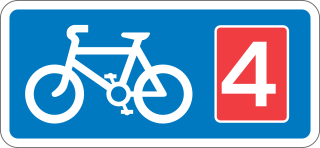
National Cycle Route 4 is a route of the National Cycle Network, running from London to Fishguard, Pembrokeshire. Between these, the route runs through Reading, Bath, Bristol, Newport, Swansea and St David's. Within Wales, sections of the route follow branches of the Celtic Trail cycle route.
National Cycle Route 6 is a route of the National Cycle Network, running from London to the Lake District.
The Monkland Railways was a railway company formed in 1848 by the merger of three "coal railways" that had been built to serve coal and iron pits around Airdrie in Central Scotland, and connect them to canals for onward transport of the minerals. The newly formed company had a network stretching from Kirkintilloch to Causewayend, near Linlithgow. These coal railways had had mixed fortunes; the discovery of blackband ironstone and the development of the iron smelting industry around Coatbridge had led to phenomenal success, but hoped-for mineral discoveries in the moorland around Slamannan had been disappointing. The pioneering nature of the railways left them with a legacy of obsolete track and locomotives, and new, more modern, railways were being built around them.
National Cycle Route 75 runs from Edinburgh to Tarbert on the Kintyre peninsula, via Glasgow. It is often known as the Clyde to Forth cycle route.
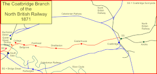
The Coatbridge Branch of the North British Railway was a railway built to connect the important coal and iron industrial districts of Coatbridge and Airdrie directly to Glasgow for the North British Railway.
The Kelvin Valley Railway was an independent railway designed to connect Kilsyth, an important mining town in central Scotland, with the railway network. It connected Kilsyth to Kirkintilloch and thence over other railways to the ironworks of Coatbridge, and to Maryhill, connecting onwards to the Queen's Dock at Stobcross.

National Cycle Network (NCN) Route 69 is a Sustrans National Route that runs from Hest Bank to Cleethorpes. The route is incomplete and consists of one long section in Lancashire, and seven short sections in West Yorkshire. The open sections are signed in both directions.