Strud

Last updated
Strud
Strud - Village - JPG1.jpg
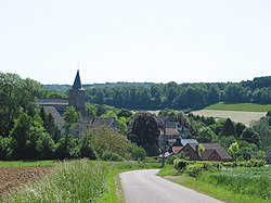
Strud with its medieval church
Belgium location map.svg
Red pog.svg
Strud
Europe blank laea location map.svg
Red pog.svg
Strud
Coordinates: 50°27′04″N05°03′23″E / 50.45111°N 5.05639°E / 50.45111; 5.05639
CountryFlag of Belgium (civil).svg  Belgium
Region Flag of Wallonia.svg  Wallonia
Province Blason namur prov.svg Namur
Municipality Blason Gesves.svg Gesves

Strud is a hamlet of the village of Haltinne, Wallonia, located in the municipality of Gesves, province of Namur, Belgium.

The village church dates from the 11th century, and has a tower from the 9th century (with a 17th-century spire). It was expanded in 1891 and renovated in 1931. About 1 kilometre (0.62 miles) south of the village centre lies a manor (manoir de Labas) known since 1343, subsequently destroyed and rebuilt during the 17th century. [1]

A Devonian lagerstätte is known from the area, containing fossils of fairy shrimp, notostracans [2] and possible insects. [3]

References

  1. Menne, Gilbert, ed. (2014). Le grand guide de Wallonie et de Bruxelles. Brussels: Racine. p. 485. ISBN   978 94 014 1418 0.
  2. Gueriau, Pierre; Rabet, Nicolas; Clément, Gaël; Lagebro, Linda; Vannier, Jean; Briggs, Derek E.G.; Charbonnier, Sylvain; Olive, Sébastien; Béthoux, Olivier (February 2016). "A 365-Million-Year-Old Freshwater Community Reveals Morphological and Ecological Stasis in Branchiopod Crustaceans". Current Biology. 26 (3): 383–390. doi:10.1016/j.cub.2015.12.039.
  3. Garrouste, Romain; Clément, Gaël; Nel, Patricia; Engel, Michael S.; Grandcolas, Philippe; D’Haese, Cyrille; Lagebro, Linda; Denayer, Julien; Gueriau, Pierre; Lafaite, Patrick; Olive, Sébastien; Prestianni, Cyrille; Nel, André (2 August 2012). "A complete insect from the Late Devonian period". Nature. 488 (7409): 82–85. doi:10.1038/nature11281.