Gmina Nawojowa is a rural gmina in Nowy Sącz County, Lesser Poland Voivodeship, in southern Poland. Its seat is the village of Nawojowa, which lies approximately 8 kilometres (5 mi) south-east of Nowy Sącz and 81 km (50 mi) south-east of the regional capital Kraków.
Gmina Piwniczna-Zdrój is an urban-rural gmina in Nowy Sącz County, Lesser Poland Voivodeship, in southern Poland, on the Slovak border. Its seat is the town of Piwniczna-Zdrój, which lies approximately 21 kilometres (13 mi) south of Nowy Sącz and 89 km (55 mi) south-east of the regional capital Kraków.
Gmina Stary Sącz is an urban-rural gmina in Nowy Sącz County, Lesser Poland Voivodeship, in southern Poland. Its seat is the town of Stary Sącz, which lies approximately 9 kilometres (6 mi) south-west of Nowy Sącz and 75 km (47 mi) south-east of the regional capital Kraków.

Januszowa is a village in the administrative district of Gmina Chełmiec, within Nowy Sącz County, Lesser Poland Voivodeship, in southern Poland. It lies approximately 6 kilometres (4 mi) east of Chełmiec, 4 km (2 mi) north-east of Nowy Sącz, and 74 km (46 mi) south-east of the regional capital Kraków.
Kunów is a village in the administrative district of Gmina Chełmiec, within Nowy Sącz County, Lesser Poland Voivodeship, in southern Poland. It lies approximately 8 kilometres (5 mi) south-east of Chełmiec, 6 km (4 mi) south-east of Nowy Sącz, and 79 km (49 mi) south-east of the regional capital Kraków.
Naściszowa is a village in the administrative district of Gmina Chełmiec, within Nowy Sącz County, Lesser Poland Voivodeship, in southern Poland. It lies approximately 5 kilometres (3 mi) north-east of Chełmiec, 4 km (2 mi) north-east of Nowy Sącz, and 73 km (45 mi) south-east of the regional capital Kraków.
Paszyn is a village in the administrative district of Gmina Chełmiec, within Nowy Sącz County, Lesser Poland Voivodeship, in southern Poland. It lies approximately 9 kilometres (6 mi) east of Chełmiec, 7 km (4 mi) east of Nowy Sącz, and 78 km (48 mi) south-east of the regional capital Kraków.
Wielopole is a village in the administrative district of Gmina Chełmiec, within Nowy Sącz County, Lesser Poland Voivodeship, in southern Poland. It lies approximately 5 kilometres (3 mi) north-east of Chełmiec, 5 km (3 mi) north of Nowy Sącz, and 71 km (44 mi) south-east of the regional capital Kraków.
Czyrna is a village in the administrative district of Gmina Krynica-Zdrój, within Nowy Sącz County, Lesser Poland Voivodeship, in southern Poland, close to the border with Slovakia. It lies approximately 10 kilometres (6 mi) north-east of Krynica-Zdrój, 29 km (18 mi) south-east of Nowy Sącz, and 102 km (63 mi) south-east of the regional capital Kraków.

Piorunka is a village in the administrative district of Gmina Krynica-Zdrój, within Nowy Sącz County, Lesser Poland Voivodeship, in southern Poland, close to the border with Slovakia. It lies approximately 9 kilometres (6 mi) north of Krynica-Zdrój, 27 km (17 mi) south-east of Nowy Sącz, and 100 km (62 mi) south-east of the regional capital Kraków.
Uhryń is a village in the administrative district of Gmina Łabowa, within Nowy Sącz County, Lesser Poland Voivodeship, in southern Poland. It lies approximately 6 kilometres (4 mi) south of Łabowa, 20 km (12 mi) south-east of Nowy Sącz, and 93 km (58 mi) south-east of the regional capital Kraków.
Białawoda is a village in the administrative district of Gmina Łososina Dolna, within Nowy Sącz County, Lesser Poland Voivodeship, in southern Poland. It lies approximately 8 kilometres (5 mi) south of Łososina Dolna, 9 km (6 mi) north-west of Nowy Sącz, and 66 km (41 mi) south-east of the regional capital Kraków.
Młodów is a village in the administrative district of Gmina Piwniczna-Zdrój, within Nowy Sącz County, Lesser Poland Voivodeship, in southern Poland, close to the border with Slovakia. It lies approximately 5 kilometres (3 mi) north-west of Piwniczna-Zdrój, 18 km (11 mi) south of Nowy Sącz, and 85 km (53 mi) south-east of the regional capital Kraków.
Obłazy Ryterskie is a village in the administrative district of Gmina Rytro, within Nowy Sącz County, Lesser Poland Voivodeship, in southern Poland. It lies approximately 2 kilometres (1 mi) south of Rytro, 17 km (11 mi) south of Nowy Sącz, and 84 km (52 mi) south-east of the regional capital Kraków.

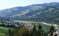
Rytro is a village in Nowy Sącz County, Lesser Poland Voivodeship, in southern Poland. It is the seat of the gmina called Gmina Rytro. It lies approximately 16 kilometres (10 mi) south of Nowy Sącz and 83 km (52 mi) south-east of the regional capital Kraków.
Gaboń is a village in the administrative district of Gmina Stary Sącz, within Nowy Sącz County, Lesser Poland Voivodeship, in southern Poland. It lies approximately 7 kilometres (4 mi) south-west of Stary Sącz, 15 km (9 mi) south-west of Nowy Sącz, and 74 km (46 mi) south-east of the regional capital Kraków.

Łazy Biegonickie is a village in the administrative district of Gmina Stary Sącz, within Nowy Sącz County, Lesser Poland Voivodeship, in southern Poland. It lies approximately 4 kilometres (2 mi) east of Stary Sącz, 7 km (4 mi) south of Nowy Sącz, and 77 km (48 mi) south-east of the regional capital Kraków.
Mostki is a village in the administrative district of Gmina Stary Sącz, within Nowy Sącz County, Lesser Poland Voivodeship, in southern Poland. It lies approximately 4 kilometres (2 mi) west of Stary Sącz, 11 km (7 mi) south-west of Nowy Sącz, and 74 km (46 mi) south-east of the regional capital Kraków.
Myślec is a village in the administrative district of Gmina Stary Sącz, within Nowy Sącz County, Lesser Poland Voivodeship, in southern Poland. It lies approximately 3 kilometres (2 mi) south-east of Stary Sącz, 9 km (6 mi) south of Nowy Sącz, and 78 km (48 mi) south-east of the regional capital Kraków.
Popowice is a village in the administrative district of Gmina Stary Sącz, within Nowy Sącz County, Lesser Poland Voivodeship, in southern Poland. It lies approximately 4 kilometres (2 mi) south-east of Stary Sącz, 10 km (6 mi) south of Nowy Sącz, and 78 km (48 mi) south-east of the regional capital Kraków.