
The Orange River is a river in Southern Africa. It is the longest river in South Africa. With a total length of 2,432 km (1,511 mi), the Orange River Basin extends from Lesotho into South Africa and Namibia to the north. It rises in the Drakensberg mountains in Lesotho, flowing westwards through South Africa to the Atlantic Ocean. The river forms part of the international borders between South Africa and Lesotho and between South Africa and Namibia, as well as several provincial borders within South Africa. Except for Upington, it does not pass through any major cities. The Orange River plays an important role in the South African economy by providing water for irrigation and hydroelectric power. The river was named the Orange River in honour of the Dutch ruling family, the House of Orange, by the Dutch explorer Robert Jacob Gordon. Other names include simply the word for river, in Khoekhoegowab orthography written as !Garib, which is rendered in Afrikaans as Gariep River with the intrusion of a velar fricative in place of the alveolar click, Groote River or Senqu River, derived from ǂNū "Black". It is known in isiZulu as isAngqu.

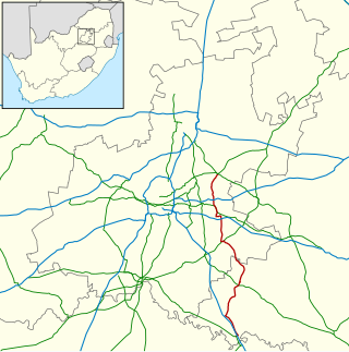
The Vaal River is the largest tributary of the Orange River in South Africa. The river has its source near Breyten in Mpumalanga province, east of Johannesburg and about 30 kilometres (19 mi) north of Ermelo and only about 240 kilometres (150 mi) from the Indian Ocean. It then flows westwards to its confluence with the Orange River southwest of Kimberley in the Northern Cape. It is 1,458 kilometres (906 mi) long, and forms the border between Mpumalanga, Gauteng and North West Province on its north bank, and the Free State on its south.

The Vaal Dam in South Africa was constructed in 1938 and lies 77 km south of OR Tambo International Airport, Johannesburg. The lake behind the dam wall has a surface area of about 320 square kilometres (120 sq mi) and is 47 meters deep. The Vaal Dam lies on the Vaal River, which is one of South Africa's strongest-flowing rivers. Other rivers flowing into the dam are the Wilge River, Molspruit and Grootspruit. It has over 800 kilometres (500 mi) of shoreline and is South Africa's second biggest dam by area and the fourth largest by volume.

Vereeniging is a city located in the south of Gauteng province, South Africa, situated where the Klip River empties into the northern loop of the Vaal River. It is also one of the constituent parts of the Vaal Triangle region and was formerly situated in the Transvaal province. The name Vereeniging is the Dutch word meaning "association", although the spelling has since changed to vereniging, with a single e.

Suikerbosrand Nature Reserve is a protected area which encompasses most of the Suikerbosrand Range, South Africa. It is one of Gauteng’s most frequented ecotourism locations, located approximately 50 kilometres south-east of Johannesburg, just west of the town of Heidelberg in the upper catchment of the Klip and Suikerbosrand rivers. The altitude varies between 1,545 and 1,917 m above sea level.

The Highveld is the portion of the South African inland plateau which has an altitude above roughly 1,500 m (4,900 ft), but below 2,100 m (6,900 ft), thus excluding the Lesotho mountain regions to the south-east of the Highveld. It is home to some of the country's most important commercial farming areas, as well as its largest concentration of metropolitan centres, especially the Gauteng conurbation, which accommodates one-third of South Africa's population.

The R23 is a provincial route in South Africa that links Benoni with Volksrust via Brakpan, Heidelberg and Standerton.

The R42 is a provincial route in South Africa that connects Vanderbijlpark with Bronkhorstspruit via Vereeniging, Heidelberg, Nigel and Delmas.
The R51 is a provincial route in South Africa that connects Bapsfontein with the N3 north of Villiers, via Springs, Nigel and Balfour.

The R54 is a provincial route in South Africa that connects Potchefstroom with Villiers via Vereeniging.

The Sedibeng District Municipality is one of the districts of the Gauteng province of South Africa. The administrative seat of the district is Vereeniging. As of 2011, the most widely spoken language among its 794,605 inhabitants was Sesotho.

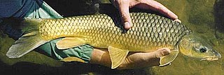
The largemouth yellowfish or Vaal-Orange largemouth yellowfish is a ray-finned fish species in the family Cyprinidae. This large freshwater barb is found in southern Africa.

Marievale Bird Sanctuary is a protected area in Gauteng, South Africa. It is about 15 km2 in size, and situated on the East Rand on the southern half of the Blesbokspruit wetland, a Ramsar site. The Blesbokspruit is a major perennial river in Gauteng which is flanked by extensive floodplains on either side. Nearby is the Suikerbosrand Nature Reserve.
The smallmouth yellowfish is a species of ray-finned fish in the genus Labeobarbus. It has become an invasive species in rivers of the Eastern Cape, South Africa, such as the Mbhashe River.
The Blesbokspruit is a river in Gauteng, South Africa that originates north of Daveyton, from where it runs south and then west past the towns of Springs, Nigel and Heidelberg before joining the Suikerbosrand River, a tributary of the Vaal River.
The Vaal River Barrage Reservoir is a dam on the Vaal River near Vanderbijlpark, border Gauteng and Free State, South Africa.

The Wilge River is a tributary of the Vaal River in central South Africa. This river is important as part of the Tugela-Vaal Water Transfer Scheme where water is transferred from the Tugela River basin to the Vaal River basin.
The R549 is a Regional Route in South Africa that connects Heidelberg in Gauteng with Deneysville in the Free State.

The Klip River is the main river draining the portion of Johannesburg south of the Witwatersrand, and its basin includes the Johannesburg CBD and Soweto. The mouth of the river is at Vereeniging where it empties into the Vaal River, which is a tributary to the Orange River. Besides Vereeniging, other towns along the river include Henley on Klip, Lenasia and Meyerton.

Rand Water is a South African water utility that supplies potable water to the Gauteng province and other areas of the country and is the largest water utility in Africa. The water is drawn from numerous sources and is purified and supplied to industry, mining and local municipalities and is also involved in sanitation of waste water.

