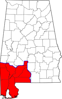
Area code 251 is a telephone numbering plan code covering southwestern Alabama serving Mobile, Baldwin, and Washington counties and parts of six other counties. It was created on June 18, 2001, as a split from area code 334. In order to allow people time to reprogram electronics such as computers, cell phones, pagers and fax machines, use of the 334 area code continued in the 251 areas through January 7, 2002.

The Ulúa River is a river in western Honduras. It rises in the central mountainous area of the country close to La Paz and runs 240 kilometres (150 mi) approximately due northwards to the east end of the Gulf of Honduras at 15°55′N87°43′W. En route, it is joined by the Sulaco River, the Jicatuyo River, the Otoro River and the Chamelecón River. The Ulúa River valley is famed for its ornate calcite vessels that date from the Mayan times. One of them can be found in the British Museum's collection.

San Juan de Flores is a municipality in the Honduran department of Francisco Morazán.
Inguilpata is a district in the Luya Province, Perú. Inguilpata is located in the high mountains, it offers several attractive places for tourists such as the ruins of the Chachapoya culture as well as a large variety of crafts are available.

Petrovany is a village and municipality in Prešov District in the Prešov Region of eastern Slovakia.

Rozsály is a village in Szabolcs-Szatmár-Bereg county, in the Northern Great Plain region of eastern Hungary.
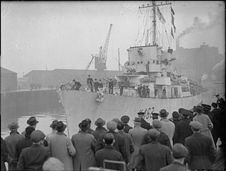
HMS Affleck was a Captain class frigate which served during World War II. The ship was named after Sir Edmund Affleck, commander of HMS Bedford at the Moonlight Battle in 1780 during the American Revolutionary War.
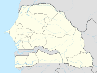
Mpal is a town and commune in Saint-Louis Region in north-western Senegal. It lies on a branch railway of the Senegal Railway system.

Aldeanueva del Camino is a municipality located in the province of Cáceres, Extremadura, Spain. According to the 2006 census (INE), the municipality has a population of 830 inhabitants.
Mecklenburgische Kleinseenplatte is an Amt in the Mecklenburgische Seenplatte district, in Mecklenburg-Vorpommern, Germany. The seat of the Amt is in Mirow.
Meander Glacier is a large meandering tributary to Mariner Glacier in Victoria Land, Antarctica. The glacier emerges in the vicinity of Mount Supernal and Hobbie Ridge and drains generally eastward for 30 nautical miles (56 km) through the Mountaineer Range to join Mariner Glacier just east of Engberg Bluff. The descriptive name was given by the New Zealand Geological Survey Antarctic Expedition, 1962–63.
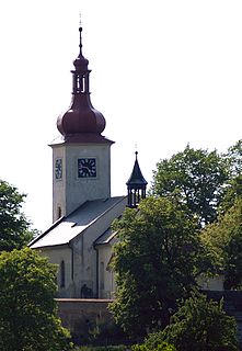
Křesetice is a village and municipality in Kutná Hora District in the Central Bohemian Region of the Czech Republic.
Landri Sales is a municipality in the state of Piauí in the Northeast region of Brazil.
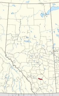
Siksika 146 is a First Nations reserve in southern Alberta, Canada. It has a land area of 696.54 km2, making it the second-largest Indigenous reserve in Canada. It is located 87 kilometres (54 mi) southeast of Calgary and is inhabited by members of the Siksika Nation. It is bordered by Vulcan County, Wheatland County, and the County of Newell, and is located at an elevation of 857 metres (2,812 ft). The Canada 2011 Census reported a population of 2,972 inhabitants. The reserve is home to the Blackfoot Crossing historical park.
Gledatsi is a village in Gabrovo Municipality, in Gabrovo Province, in northern central Bulgaria.
Petsovtsi is a village in Gabrovo Municipality, in Gabrovo Province, in northern central Bulgaria.
Peyovtsi is a village in Gabrovo Municipality, in Gabrovo Province, in northern central Bulgaria.
Karala, Estonia is a village in Saaremaa Parish,(previously Lümanda Parish), Saare County in western Estonia.

Hondón de los Frailes is a municipality and village in the province of Alicante and autonomous community of Valencia, Spain. The municipality covers an area of 12.6 square kilometres (4.9 sq mi) and as of 2011 had a population of 1217 people.
Biriwa Chiefdom is a chiefdom in Bombali District of Sierra Leone. Its capital is Kamabai.