Related Research Articles

The kipunji, also known as the highland mangabey, is a species of Old World monkey that lives in the highland forests of Tanzania. The kipunji has a unique call, described as a 'honk-bark', which distinguishes it from its relatives, the grey-cheeked mangabey and the black crested mangabey, whose calls are described as 'whoop-gobbles'.

Ileje District is a district in Songwe Region, Tanzania. It is bordered to the north by Mbeya Urban and Rungwe districts, to the east by Kyela District, to the northwest by Mbozi District and to the south by Zambia and Malawi.

Rungwe is a District in Mbeya Region, Tanzania. It is bordered to the north by Mbeya Rural District, to the east by Busokelo District, to the southeast by Kyela District, to the southwest by Ileje District and to the west by Mbeya District.

Mount Rungwe is a volcanic mountain in Mbeya Region, in Tanzania's Southern Highlands. At an altitude of 2,981 metres (9,780 ft), it is southern Tanzania's second-highest peak. Rungwe's volcano is currently inactive.

Tukuyu, known as Neu Langenburg during the German colonial rule, is a hillside town that lies about 36 miles (58 km) south of the city of Mbeya, at an elevation of around 5,000 ft (1,500 m) in the highland Rungwe District of southern Tanzania, East Africa. Tukuyu town has a moderate to cool temperature ranging from 10 °C in May and June to mid 20 °C in around November. The town and surrounding areas are green all year round due to the almost year-round convectional rains resulting from Lake Nyasa(Lake Malawi).Tukuyu town is divided into several wards include; Kawetere, Msasani, Bulyaga and Bagamoyo.
Katumba is an administrative ward in the Rungwe District of the Mbeya Region of Tanzania. According to the 2002 census, the ward has a total population of 10,965.
Mpuguso is an administrative ward in the Rungwe district of the Mbeya Region of Tanzania. According to the 2002 census, the ward has a total population of 12,223.
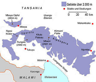
The Poroto Mountains are a mountain range in the Mbeya Region of Tanzania. They are located east of the city of Mbeya. The Poroto Mountains are a northwestward extension of the Kipengere Range, and part of the Southern Highlands. The Poroto mountains are volcanic in origin, part of the geological Rungwe Volcanic Province.

Kiwira River is a river located in Rungwe District and Kyela District of Mbeya Region, Tanzania.

Mbaka River is a river of Mbeya Region, Tanzania. It originates on the south slopes of Mount Rungwe and flows southeast into the north end of Lake Malawi at Mwaya.
Mwatisi is a river of Tanzania. It flows through the Mbeya Region.
The Southern Highlands is a highland region in southwestern Tanzania, at the northern end of Lake Malawi. The highlands include portions of Mbeya, Njombe, Rukwa, Ruvuma, and Songwe regions, bordering Malawi, Mozambique, and Zambia. Mbeya is the largest city in the highlands.
Lupope is an administrative ward in Rungwe District, Mbeya Region, Tanzania. As of 2002, the ward had a total population of 14,284.
Makandana is an administrative ward in Rungwe District, Mbeya Region, Tanzania. As of 2002, the ward had a total population of 14,284.
Masebe is an administrative ward in Rungwe District, Mbeya Region, Tanzania. As of 2002, the ward had a total population of 14,284.
Masoko is an administrative ward in Rungwe District, Mbeya Region, Tanzania. As of 2002, the ward had a total population of 14,284.
Matwebe is an administrative ward in Rungwe District, Mbeya Region, Tanzania. As of 2002, the ward had a total population of 14,284.
Ndato is an administrative ward in Rungwe District, Mbeya Region, Tanzania. As of 2002, the ward had a total population of 14,284.
Swaya is an administrative ward in Rungwe District, Mbeya Region, Tanzania. As of 2002, the ward had a total population of 14,284.
Suma is an administrative ward in Rungwe District, Mbeya Region, Tanzania. As of 2002, the ward had a total population of 11,448.
References
- ↑ "Rungwe Mountain Catchment Reserve". Utalii Travel & Safaris. Retrieved 4 June 2017.
9°17′10″S33°43′05″E / 9.28601°S 33.71794°E