
Guam is an organized, unincorporated territory of the United States in Micronesia in the western Pacific Ocean. It is the westernmost point and territory of the United States. The capital city of Guam is Hagåtña, and the most populous city is Dededo. Guam has been a member of the Pacific Community since 1983. The inhabitants of Guam are American citizens by birth. The indigenous Guamanians are the Chamorros, who are related to other Austronesian peoples of Indonesia, the Philippines, Taiwan, Micronesia, and Polynesia.

Antonio Borja Won Pat was a Guamanian politician and member of the Democratic Party of Guam. He served the first Delegate from Guam to the United States House of Representatives from 1973 to 1985.

Apra Harbor, also called Port Apra, is a deep-water port on the western side of the United States territory of Guam. The harbor is formed by Orote Peninsula in the south and Cabras Island in the north. To the south, the harbor narrows and then widens again to form an inner harbor. The southern end of the harbor is the location of Naval Base Guam. The northern end is the commercial port, which handles about 2 million tons of cargo a year. It is considered one of the best natural ports in the Pacific and attracts many tourists.

Sumay-ye Beradust District is a district (bakhsh) in Urmia County, West Azerbaijan Province, Iran. It is west of Lake Urmia, between the city of Urmia and the border with Turkey. Its administrative seat is the town of Serow. At the 2006 census, its population was 39,802, in 6,760 families. The District has one city: Serow. The District has three rural districts (dehestan): Beradust Rural District, Sumay-ye Jonubi Rural District, and Sumay-ye Shomali Rural District.

Santa Rita is a village located on the southwest coast of the United States territory of Guam with hills overlooking Apra Harbor. According to the 2000 census it has a population of 7,500, down from 11,857 in 1990. Santa Rita is the newest village in Guam, having been established after the Second World War.
Juan de los Reyes was a Spanish Catholic priest and evangelist who was among the protomartyrs of Guam.

The First Battle of Guam was an engagement during the Pacific War in World War II, and took place from 8 December to 10 December 1941 on Guam in the Mariana Islands between Japan and the United States. The American garrison was defeated by Japanese forces on 10 December, which resulted in an occupation until the Second Battle of Guam in 1944.

The postage stamps and postal history of Guam is an overview of the postage stamps and postal history of the United States territory of Guam. Its postal service is linked to those of the Philippines during the Spanish Empire and, since 1898, to the United States of America. A peculiarity is that, for a short period in the 1930s, Guam had a local post service.

Naval Base Guam is a strategic U.S. naval base located on Apra Harbor, Guam. In 2009, it was combined with Andersen Air Force Base, to form Joint Region Marianas, which is a Navy-controlled joint base.

Aghsaqal is a village in Sumay-ye Jonubi Rural District, Sumay-ye Beradust District, Urmia County, West Azerbaijan Province, Iran. At the 2006 census, its population was 675, in 104 families.
Sumay-ye Jonubi Rural District is a rural district (dehestan) in Sumay-ye Beradust District, Urmia County, West Azerbaijan Province, Iran. At the 2006 census, its population was 13,915, in 2,258 families. The rural district has 23 villages.
Piranjuq is a village in Sumay-ye Jonubi Rural District, Sumay-ye Beradust District, Urmia County, West Azerbaijan Province, Iran. At the 2006 census, its population was 632, in 107 families.
Soltani is a village in Sumay-ye Jonubi Rural District, Sumay-ye Beradust District, Urmia County, West Azerbaijan Province, Iran. At the 2006 census, its population was 609, in 123 families.
Khanik is a village in Sumay-ye Shomali Rural District, Sumay-ye Beradust District, Urmia County, West Azerbaijan Province, Iran. At the 2006 census, its population was 244, in 47 families.
Quni is a village in Sumay-ye Shomali Rural District, Sumay-ye Beradust District, Urmia County, West Azerbaijan Province, Iran. At the 2006 census, its population was 898, in 140 families.
Judith Teresita Perez Won Pat, also known as Judi Won Pat, is a Guamanian politician, and teacher who served as the speaker of the Guam Legislature from 2009 to 2017. A member of the Democratic Party from Guam, served as the senator of the Guam Legislature from 1994 to 2003 and again from 2005 to 2017. Won Pat was the former sitting chairperson of the Committee on Education, Public Library and Women’s Affairs in the 32nd Guam Legislature.
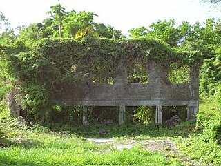
The Guam Cable Station is where the United States territory of Guam was first connected via modern telecommunications to the rest of the world. Reduced to ruins by the fighting of World War II, the ruins of the establishment remain on the grounds of Naval Base Guam on the west side of the island. In 1901, the Commercial Pacific Cable Company offered to lay a cable between the Continental United States and Guam at no cost to the federal government. In 1903 the company began construction of a series of buildings near what was the small village of Sumay. Designed to be proof against typhoons, earthquakes, and other perils, the complex included the main cable station building, several buildings of living quarters, and a self-contained water supply system. The cable connecting Guam to Hawaii was completed in June 1903, marking the complete encirclement of the globe by communications cables. This station became a major communications hub, eventually also housing cables to China and the island of Yap, and becoming an early-warning center for typhoons. Operation of the cable was interrupted by the Japanese capture of Guam in 1941. It resumed with the liberation of Guam in 1944, but continued only until 1951, when the cable between Guam and Hawaii was broken. Since then the remains of the cable station have been succumbing to the elements. Its remains were listed on the National Register of Historic Places in 1979.

The Sumay Cemetery is a historic cemetery at the junction of Sumay Drive and Guam Highway 1 on the grounds of Naval Base Guam, located on the west side of the United States territory of Guam. It is a roughly square cemetery taking up about 0.7 acres (0.28 ha), and is surrounded by a decorative wall with gate. The cemetery was probably established in the late 19th century; its oldest legible marker bears the date 1911. It is the oldest known historic-era cemetery on the island, and is the only tangible reminder of the village of Sumay, which effectively ceased to exist when the naval base took over the area and its citizens were relocated to the village of Santa Rita.
