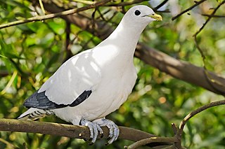
The Brook Islands National Park is a national park in Cassowary Coast Region, Queensland, Australia, 1246 km northwest of Brisbane, with an area of 0.9 km2. It was established in 1994 and comprises three islands which lie off the coast 7 km north-east of Cape Richards on Hinchinbrook Island and 30 km east of the nearest mainland town of Cardwell. The fourth island of the Brooks group, South Island, is not part of the national park but is protected by the Great Barrier Reef Marine Park Authority. Public access to the three islands in the national park is prohibited in order to protect breeding birds, especially the Torresian imperial-pigeon. The islands have no roads, walking tracks or other facilities. Popular activities in the waters around the islands are boating, snorkelling and fishing. The islands are managed by the Queensland Parks and Wildlife Service. The Park's IUCN category is II.

Goold Island is a national park in Queensland, Australia, 1,250 km (780 mi) northwest of Brisbane. The island is close to the northern tip of Hinchinbrook Island off the coast from Cardwell in Rockingham Bay and is part of the Great Barrier Reef World Heritage Area.

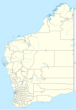
The Montebello Islands, also rendered as the Monte Bello Islands, are an archipelago of around 174 small islands lying 20 km (12 mi) north of Barrow Island and 130 km (81 mi) off the Pilbara coast of north-western Australia. The islands form a marine conservation reserve of 58,331 ha administered by the Western Australian Department of Environment and Conservation. The islands were the site of three British atmospheric nuclear weapons tests in 1952 and 1956.

The bush stone-curlew or bush thick-knee, also known as the Iben bird is a large, ground-dwelling bird endemic to Australia. Its favoured habitat is open plains and woodlands, where it stalks slowly at night in search of invertebrates such as insects. Its grey-brown coloration is distinguished by dark streaks, its eyes are large and legs are long. It is capable of flight, but relies on the camouflage of its plumage to evade detection during the day; the bush curlew adopts a rigid posture when it becomes aware of an observer. Both sexes care for two eggs laid on the bare ground, usually sited near bush in a shaded position or next to a fallen branch.

The Kimberley is the northernmost of the nine regions of Western Australia. It is bordered on the west by the Indian Ocean, on the north by the Timor Sea, on the south by the Great Sandy and Tanami deserts in the region of the Pilbara, and on the east by the Northern Territory.

Eighty Mile Beach, also spelled Eighty-mile Beach or 80-mile Beach, lies along the north-west coast of Western Australia about half-way between the towns of Broome and Port Hedland. It is a beach some 220 kilometres (140 mi) in length, forming the coastline where the Great Sandy Desert approaches the Indian Ocean. It is one of the most important sites for migratory shorebirds, or waders, in Australia, and is recognised as a wetland of international importance under the Ramsar Convention on Wetlands.
Cape Leveque is at the northernmost tip of the Dampier Peninsula in the Kimberley region of Western Australia. Cape Leveque is 240 kilometres (150 mi) north of Broome, and is remote with few facilities. Nevertheless, the Cape's sandy beaches are attracting an increasing number of visitors.

King Sound is a large gulf in northern Western Australia. It expands from the mouth of the Fitzroy River, one of Australia's largest watercourses, and opens to the Indian Ocean. It is about 120 kilometres (75 mi) long, and averages about 50 kilometres (31 mi) in width. The port town of Derby lies near the mouth of the Fitzroy River on the eastern shore of King Sound. King Sound has the highest tides in Australia, and amongst the highest in the world, reaching a maximum tidal range of 11.8 metres (39 ft) at Derby. The tidal range and water dynamic were researched in 1997–1998.

The Swan Bay is a shallow, 30-square-kilometre (12 sq mi) marine embayment at the eastern end of the Bellarine Peninsula in Port Phillip, Victoria, Australia. The township of Queenscliff lies at its southern end, and St Leonards at its northern. It is partly separated from Port Phillip by Swan Island, Duck Island and Edwards Point. Most of the area is included in the Port Phillip Heads Marine National Park as well as being listed as a wetland of international importance under the Ramsar Convention as part of the Port Phillip Bay and Bellarine Peninsula Ramsar Site. The bay is part of the Swan Bay and Port Phillip Bay Islands Important Bird Area, identified as such by BirdLife International because of its importance for orange-bellied parrots, waders and seabirds.

The Lacepede Islands, sometimes referred to simply as the Lacepedes, are a group of four islands lying off the Kimberley coast of Western Australia, about 120 kilometres north of Broome.

The Northwest Shelf Province, also known as Exmouth to Broome, is a biogeographic region of Australia's continental shelf.

The Northwest Shelf Transition, also known as Bonaparte Coast, is a biogeographic region of Australia's continental shelf. It adjoins the Kimberley region of Western Australia and the adjacent coast of the Northern Territory.
Robbins Island is a 9,900-hectare (24,000-acre) island located in Bass Strait, lying off the northwest coast of Tasmania, Australia. The island, separated from the Tasmanian mainland by a highly tidal area known as Robbins Passage, lies south to the adjacent Walker Island.

The Low Rocks and Sterna Island Important Bird Area comprises two islets lying about 14 km apart and with a collective area of 14 ha, in the Montesquieu group of islands, in the mouth of Admiralty Gulf in the Kimberley region of Western Australia.
Mudaliarkuppam Boat House, also known as Raindrop Boat House, is a water sport facility located on the East Coast Road, 36 km to the south of Mamallapuram and 92 km from Chennai in India. It was developed by the Tamil Nadu Tourism Development Corporation on the Odiyur lake back waters. It has rowing, cruising, speed boating, water scooting and kayaking facilities.
Tumby Island is a low bedrock island located 500 m east of the southern tip of Tumby Bay in Spencer Gulf, South Australia. The island is a conservation park comprising 35 hectares. The island can be accessed on foot at low tide by traversing shallow water-covered rock flats and curving sand. Visitors should request access permission from DEWNR before visiting and be mindful of the presence of Death adders.
Champagny Island, known to the Traditional Owners as Nimenba, is an island off the coast of the Kimberley region in Western Australia.
Busby Islet is an islet in the Australian state of South Australia located in Nepean Bay on the north coast of Kangaroo Island about 2 kilometres north of the municipal seat of Kingscote. The islet and adjoining areas are notable as habitat for bird life. The islet has enjoyed protected area status since 1909 and since at least 1972, have been part of the Busby Islet Conservation Park.
Rabbit Island is a rarely visited 32 hectares island located in Louth Bay, Spencer Gulf, South Australia. It also bears the historic French name of Ile Raynal. Unlike the larger, privately owned Louth Island which sits 3 kilometres to the north-west, Rabbit Island is public land and part of the Lincoln National Park. A diversity of native flora and fauna species have been recorded on the island.

The Bardi people, also spelt Baada or Baardi and other variations, are an Aboriginal Australian people, living north of Broome and inhabiting parts of the Dampier Peninsula in the Kimberley region of Western Australia. They are ethnically close to the Jawi people, and several organisations refer to the Bardi Jawi grouping, such as the Bardi Jawi Niimidiman Aboriginal Corporation Registered Native Title Body (RNTBC) and the Bardi Jawi Rangers.