Related Research Articles

The Orange River is a river in Southern Africa. It is the longest river in South Africa. With a total length of 2,432 km (1,511 mi), the Orange River Basin extends from Lesotho into South Africa and Namibia to the north. It rises in the Drakensberg mountains in Lesotho, flowing westwards through South Africa to the Atlantic Ocean. The river forms part of the international borders between South Africa and Lesotho and between South Africa and Namibia, as well as several provincial borders within South Africa. Except for Upington, it does not pass through any major cities. The Orange River plays an important role in the South African economy by providing water for irrigation and hydroelectric power. The river was named the Orange River in honour of the Dutch ruling family, the House of Orange, by the Dutch explorer Robert Jacob Gordon. Other names include simply the word for river, in Khoekhoegowab orthography written as !Garib, which is rendered in Afrikaans as Gariep River with the intrusion of a velar fricative in place of the alveolar click, Groote River or Senqu River, derived from ǂNū "Black". It is known in isiZulu as isAngqu.

The Bow River is a river in Alberta, Canada. It begins within the Canadian Rocky Mountains and winds through the Alberta foothills onto the prairies, where it meets the Oldman River, the two then forming the South Saskatchewan River. These waters ultimately flow through the Nelson River into Hudson Bay. The Bow River runs through the city of Calgary, taking in the Elbow River at the historic site of Fort Calgary near downtown. The Bow River pathway, developed along the river's banks, is considered a part of Calgary's self-image.
White River is a small holiday and farming town situated just north of Mbombela in Mpumalanga, South Africa. The farms in the region produce tropical fruits, macadamia nuts, vegetables, flowers and timber. As of 2011, White River had a population of 16,639.

Benue State is one of the North Central states in Nigeria with a population of about 4,253,641 in the 2006 census. The state was created in 1976 and was among the seven states created at that time. The state derives its name from the Benue River which is the second largest river in Nigeria after the River Niger. The state borders Nasarawa State to the North; Taraba State to the East; Kogi State to the West; Enugu State to the South-West; Ebonyi and Cross-Rivers State to the South; and has an international border with Cameroon to the South-East. It is inhabited predominantly by the Tiv, Idoma, and Igede people. Minority ethnic groups in Benue are Etulo, Igbo, and Jukun people, etc. Its capital is Makurdi. Benue is a rich agricultural region; common crops include oranges, mangoes, sweet potatoes, cassava, soya bean, guinea corn, flax, yams, sesame, rice, groundnuts, and palm trees.

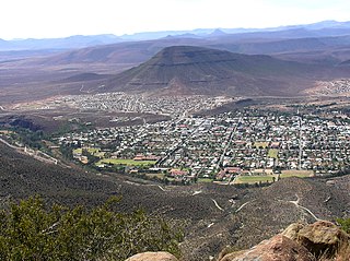
Oudtshoorn is a town in the Western Cape province of South Africa, located between the Swartberg mountains to the north and the Outeniqua Mountains to the south. Dubbed the "ostrich capital of the world", Oudtshoorn is known for its ostrich-feather booms, during 1865–1870 and 1900–1914. With approximately 60,000 inhabitants, it is the largest town in the Little Karoo region. The town's economy is primarily reliant on the ostrich farming and tourism industries. Oudtshoorn is home to the world's largest ostrich population, with a number of specialised ostrich breeding farms, such as the Safari Show Farm and the Highgate Ostrich Show Farm, as told by Mnr. Pierre D. Toit.

Gqeberha, previously named Port Elizabeth, and colloquially referred to as P.E., is a major seaport and the most populous city in the Eastern Cape province of South Africa. It is the seat of the Nelson Mandela Bay Metropolitan Municipality, South Africa's second-smallest metropolitan municipality by area. It is the sixth-most populous city in South Africa and is the cultural, economic and financial hub of the Eastern Cape.

Addo Elephant National Park is a diverse wildlife conservation park situated close to Gqeberha in South Africa and is one of the country's 20 national parks. It currently ranks third in size after Kruger National Park and the Kgalagadi Transfrontier Park.
The !Khukaǁgamma or Sundays River is a river in the Eastern Cape Province of South Africa. It is said to be the fastest flowing river in the country. The Inqua Khoi people, who historically were the wealthiest group in Southern Africa, originally named this river !Khukaǁgamma, 'the waters with the spirit of abundance' because the river's banks are always green and grassy despite the arid terrain that it runs through.
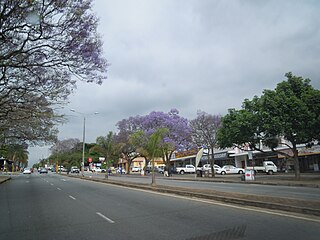
Kirkwood, officially Nqweba is a town in the Eastern Cape Province of South Africa. It is situated on the banks of the Sundays River in the eponymously named Sundays River Valley, which forms part of the Sundays River Valley Municipality in the Sarah Baartman District Municipality of the Eastern Cape.

The Renmark Paringa Council is a local government area located adjacent to the Victorian border, in the Riverland, South Australia. The area is known for its various fruit production, and is heavily dependent on the River Murray as a water source. The council seat is at Renmark.

Although agriculture is the second-largest sector in the economy, Libya depends on imports in most foods. Climatic conditions and poor soils limit farm output, and domestic food production meets about 25% of demand. Domestic conditions limit output, while income and population growth have increased food consumption. Because of low rainfall, agricultural projects like the Kufra Oasis rely on underground water sources. Libya's primary agricultural water source remains the Great Man-made River (GMMR), but significant resources are being invested in desalinization research to meet growing demand. Libyan agricultural projects and policies are overseen by a General Inspector; there is no Ministry of Agriculture, per se.

uPhongolo Municipality is a local municipality within the northern area of the Zululand District Municipality, in the KwaZulu-Natal province of South Africa.

Sundays River Valley Municipality is a local municipality within Sarah Baartman District Municipality, in the Eastern Cape province of South Africa. It has a total population of nearly 70,000 people. The municipality is one of the key production areas for citrus in South Africa. It also encompasses the Addo Elephant National Park and other significant areas of nature conservation.
Hirkan is a village and municipality in the Lankaran Rayon of Azerbaijan. It has a population of 1,781.

Kouga Municipality is a local municipality in the Eastern Cape of South Africa, approximately 80 km west of Gqebera. It forms part of the Sarah Baartman District Municipality. Its territory includes the coastal zone between the Van Stadens River in the east and the Tsitsikamma River in the west, and stretches inland towards the Baviaanskloof Mountains in the north.

Darlington Dam, also referred to as Lake Mentz, is a gravity type dam situated in the Addo Elephant National Park confining the Sundays River, near Kirkwood, in the Eastern Cape, South Africa.

Cheyyeru river is a river in the southern Indian state of Andhra Pradesh that is a tributary of the Pennar river.
The Mahaweli Development program is known as the largest multipurpose national development program in the history of Sri Lanka and is also considered the keystone of the government's development program that was initiated in 1961.

Lankaran-Astara Economic Region is one of the 14 economic regions of Azerbaijan. It borders Iran to the south and west, Caspian Sea to the east and Shirvan-Salyan Economic Region to the north. The region consists of the districts of Jalilabad, Astara, Lerik, Lankaran, Masally and Yardimli. It has an area of 6,070 square kilometres (2,340 sq mi). Its population was estimated to be at 953.6 thousand people in January 2021.
The Addo Elephant National Park Marine Protected Area is a marine conservation area in Algoa Bay, adjacent to the Nelson Mandela Bay Metropolitan Municipality, near Gqeberha, previously Port Elizabeth.
References
- 1 2 Integrated Development Plan 2009/2010. Sundays River Valley Municipality. Retrieved on Oct 14, 2009.
- 1 2 South African Panorama 1977-09: Vol 22 Iss 9. Information Service of South Africa. September 1977.
33°24′S25°26′E / 33.400°S 25.433°E
| | This Eastern Cape location article is a stub. You can help Wikipedia by expanding it. |