Solukhumbu District (Nepali: सोलुखुम्बु जिल्लाlisten , Sherpa: ཤར་ཁུམ་བུ་རྫོང་ཁ།, Kirat Rai language Wylie: shar khum bu dzong kha) is one of 14 districts of Kirat Province of eastern Nepal. As the name suggests, it consists of the subregions Solu and Khumbu.

Triyuga is an urban municipality out of 4 urban municipalities located in the Udayapur district of the Province No. 1 of Nepal. Gaighat is the headquarter of the municipality. According to the 1991 Nepal census, it had a population of 55,291. According to the 2011 Nepal census, Triyuga had 87,557 inhabitants. It is divided into 16 wards. Triyuga Municipality was established on B.S. Chaitra 13, 2053. It was named after Triyuga River. A river which flows through the town. Triyuga is the 3rd largest municipality in Nepal and 1st largest in Province No. 1 in term of size (area). The total area of the municipality is 547.43 square kilometres (211.36 sq mi)

Baksila is a village and Village Development Committee in Khotang District in the Sagarmatha Zone of eastern Nepal. At the time of the 1991 Nepal census it had a population of 3,996 persons living in 796 individual households. Baksila is located at five hours walk from Diktel, headquarters of Khotang District. Surrounded by Baspani, Sungdel, Dipsung, Rakha Saptewor and Kharmi, this village split into nine wards geographically
Baspani is a village and Village Development Committee in Khotang District in the Sagarmatha Zone of eastern Nepal. At the time of the 1991 Nepal census it had a population of 2,019 people living in 410 individual households.
Buipaबुइपा is a village and Village Development Committee in Khotang District in the Sagarmatha Zone of eastern Nepal. At the time of the 1991 Nepal census it had a population of 5,195 persons living in 980 individual households.
Chyasmitar is a town and Village Development Committee in Khotang District in the Sagarmatha Zone of eastern Nepal. At the time of the 1991 Nepal census it had a population of 2,167 persons living in 412 individual households. The Tilung language is spoken in Chyasmitar.
Dipsung is a village and Village Development Committee in Khotang District in the Sagarmatha Zone of eastern Nepal. At the time of the 1991 Nepal census, it had a population of 950 living in 205 individual households.
Jalapa is a village and also the Village Development Committee of Khotang District in the Sagarmatha Zone of eastern Nepal is located here. At the time of the 1991 Nepal census, it had a population of 2,351 persons living in 448 individual households.
Kharmi is a town and Village Development Committee in Khotang District in the Sagarmatha Zone of eastern Nepal. At the time of the 1991 Nepal census it had a population of 3,807 persons living in 723 individual households.
Khidima is a village and Village Development Committee in Khotang District in the Sagarmatha Zone of eastern Nepal. At the time of the 1991 Nepal census it had a population of 2,349 people living in 415 individual households.
Khotang Bazar is a village and Village Development Committee in Khotang District in Province No. 1 in eastern Nepal. At the time of the 1991 Nepal census, it had a population of 2,433 persons living in 458 individual households.....
Kohi is a Sino-Tibetan language belonging to the Kiranti languages spoken in the Khotang district of Nepal. Like other Kiranti languages, it displays a fairly complex system of person-marking and stem alternations. No full description of this language exists, but Lahaussois provides some grammatical information, and stories have been archived at the Lacito Archive.

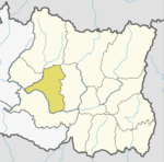
Khotehang is a rural municipality (gaunpalika) out of eight rural municipality located in Khotang District of Province No. 1 of Nepal. There are a total of 10 municipalities in Khotang in which 2 are urban and 8 are rural.
Diprung is a rural municipality (gaunpalika) out of eight rural municipality located in Khotang District of Province No. 1 of Nepal. There are a total of 10 municipalities in Khotang in which 2 are urban and 8 are rural.
Aiselukharka is a rural municipality (gaunpalika) out of eight rural municipality located in Khotang District of Province No. 1 of Nepal. There are a total of 10 municipalities in Khotang in which 2 are urban and 8 are rural.
Jantedhunga is a rural municipality (gaunpalika) out of eight rural municipality located in Khotang District of Province No. 1 of Nepal. There are a total of 10 municipalities in Khotang in which 2 are urban and 8 are rural.
Kepilasgadhi is a rural municipality (gaunpalika) out of eight rural municipality located in Khotang District of Province No. 1 of Nepal. There are a total of 10 municipalities in Khotang in which 2 are urban and 8 are rural.
Barahapokhari is a rural municipality (gaunpalika) out of eight rural municipality located in Khotang District of Province No. 1 of Nepal. There are a total of 10 municipalities in Khotang in which 2 are urban and 8 are rural.
Lamidanda is a rural municipality (gaunpalika) out of eight rural municipality located in Khotang District of Province No. 1 of Nepal. There are a total of 10 municipalities in Khotang in which 2 are urban and 8 are rural.