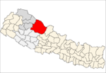
Dunai is a village and former Village Development Committee that is now part of Thuli Bheri Municipality in Nepal. Dunai is also the district headquarters of Dolpa District. The town on the banks of the Thuli Bheri River resides at about 2,000 metres (6,562 ft) elevation.

Juphalis a village and former Village Development Committee that is now part of Thuli Bheri Municipality in Nepal. The 1991 Nepal census counted 1,513 persons in 300 households.
Kaigaun is a village development committee in Dolpa District in the Karnali Zone of north-western Nepal. At the time of the 1991 Nepal census it had a population of 717 persons living in 135 individual households.

Tripurakot is a village development committee in Dolpa District in the Karnali Zone of north-western Nepal. At the time of the 1991 Nepal census it had a population of 1717 persons living in 362 individual households.
Kalika is a village development committee in Dolpa District in the Karnali Zone of north-western Nepal. At the time of the 1991 Nepal census it had a population of 902 persons living in 157 individual households.
Lawan is a village development committee in Dolpa District in the Karnali Zone of north-western Nepal. At the time of the 1991 Nepal census it had a population of 1270 persons living in 279 individual households.
Likhu is a village development committee in Dolpa District in the Karnali Zone of north-western Nepal. At the time of the 1991 Nepal census it had a population of 1465 persons living in 262 individual households.
Mazfal is a village development committee in Dolpa District in the Karnali Zone of north-western Nepal. At the time of the 1991 Nepal census it had a population of 1436 persons living in 274 individual households.
Narku is a village development committee in Dolpa District in the Karnali Zone of north-western Nepal. At the time of the 1991 Nepal census it had a population of 1025 persons living in 194 individual households.
Pahada is a village development committee in Dolpa District in the Karnali Zone of north-western Nepal. At the time of the 1991 Nepal census it had a population of 1413 persons living in 237 individual households.
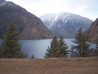
Phoksundo is a village development committee located at the village of Ringmo in the Dolpa District in the Karnali Zone of north-western Nepal. At the time of the 1991 Nepal census it had a population of 457 persons living in 94 individual households.
Raha is a village development committee and municipality in Dolpa District in the Karnali Zone of north-western Nepal. At the time of the 1991 Nepal census it had a population of 511 persons living in 110 individual households.
Rimi is a village development committee in Dolpa District in the Karnali Zone of north-western Nepal. At the time of the 1991 Nepal census, it had a population of 970 persons living in 174 individual households.
Sahartara is a village development committee in Dolpa District in the Karnali Zone of north-western Nepal. At the time of the 1991 Nepal census it had a population of 1511 persons living in 339 individual households.
Saldang is a village development committee in Dolpa District in the Karnali Zone of north-western Nepal. Saldang lies in Nankhang Valley, the most populous of the sparsely populated valleys making up the culturally Tibetan region of Dolpo. At the time of the 1991 Nepal census Saldang had a population of 1,714 in 386 individual households.
Sarmi is a village development committee in Dolpa District in the Karnali Zone of north-western Nepal. At the time of the 1991 Nepal census it had a population of 1,396 people in 279 households.
Lali is a village and municipality in Humla District in the Karnali Zone of north-western Nepal. At the time of the 1991 Nepal census it had a population of 1051 persons residing in 185 individual households.
Saya is a village and municipality in Humla District in the Karnali Zone of north-western Nepal. At the time of the 1991 Nepal census it had a population of 1422 persons living in 268 individual households.
Mahadeva is a village development committee in Saptari District in the Sagarmatha Zone of south-eastern Nepal. At the time of the 2011 Nepal census it had a population of 5,187 people living in 1,135 individual households.