Mount Rainier National Park is a national park of the United States located in southeast Pierce County and northeast Lewis County in Washington state. The park was established on March 2, 1899, as the fourth national park in the United States, preserving 236,381 acres including all of Mount Rainier, a 14,410-foot (4,390 m) stratovolcano. The mountain rises abruptly from the surrounding land with elevations in the park ranging from 1,600 feet to over 14,000 feet (490–4,300 m). The highest point in the Cascade Range, Mount Rainier is surrounded by valleys, waterfalls, subalpine meadows, and 91,000 acres of old-growth forest. More than 25 glaciers descend the flanks of the volcano, which is often shrouded in clouds that dump enormous amounts of rain and snow.
A National Parkway is a designation for a protected area in the United States given to scenic roadways with a protected corridor of surrounding parkland. National Parkways often connect cultural or historic sites. The U.S. National Park Service manages the parkways.

The Merritt Parkway is a controlled-access parkway in Fairfield County, Connecticut, with a small section at the northern end in New Haven County. Designed for Connecticut's Gold Coast, the parkway is known for its scenic layout, its uniquely styled signage, and the architecturally elaborate overpasses along the route. As one of the first, oldest parkways in the United States, it is designated as a National Scenic Byway and is also listed in the National Register of Historic Places. Signed as part of Route 15, it runs from the New York state line in Greenwich, where it serves to continue the Hutchinson River Parkway, to Exit 54 in Milford, where the Wilbur Cross Parkway begins. Facing bitter opposition, the project took six years to build in three different sections, with the Connecticut Department of Transportation constantly requiring additional funding due to the area's high property value. The parkway was named for U.S. Congressman Schuyler Merritt. In 2010, the National Trust for Historic Preservation called the Merritt Parkway one of "America's 11 Most Endangered Historic Places".

U.S. Route 97 (US 97) is a major north–south route of the United States Numbered Highway System in the Pacific Northwest region. It runs for approximately 670 miles (1,078 km) through the states of California, Oregon, and Washington, primarily serving interior areas on the east side of the Cascade Mountains. The highway terminates to the south at a junction with Interstate 5 (I-5) in Weed, California, and to the north at the Canadian border near Osoyoos, British Columbia, where it becomes British Columbia Highway 97. Major cities on the US 97 corridor include Klamath Falls, Bend, and Redmond in Oregon; and Yakima, Ellensburg, and Wenatchee in Washington. A portion of the highway in California and Oregon is part of the Volcanic Legacy Scenic Byway.

Chinook Pass is a pass through the Cascade Range in the state of Washington.

Stephen Tyng Mather was an American industrialist and conservationist who was the first director of the National Park Service. As president and owner of Thorkildsen-Mather Borax Company he became a millionaire. With his friend the journalist Robert Sterling Yard, Mather led a publicity campaign to promote the creation of a unified federal agency to oversee National Parks administration, which was established in 1916. In 1917, Mather was appointed to lead the NPS, the new agency created within the Department of the Interior. He served until 1929, during which time Mather created a professional civil service organization, increased the numbers of parks and national monuments, and established systematic criteria for adding new properties to the federal system.

The George Washington Memorial Parkway, colloquially the G.W. Parkway, is a 25-mile-long (40 km) limited-access parkway that runs along the south bank of the Potomac River from Mount Vernon, Virginia, northwest to McLean, Virginia, and is maintained by the National Park Service (NPS). It is located almost entirely in Northern Virginia, except for a short portion of the parkway northwest of the Arlington Memorial Bridge that passes over Columbia Island in Washington, D.C.

State Route 410 is a 107.44-mile (172.91 km) long state highway that traverses Pierce, King, and Yakima counties in the US state of Washington. It begins at an interchange with SR 167 in Sumner and travels southeast across the Cascade Range to a junction with U.S. Route 12 (US 12) in Naches. While the western part of SR 410 is a freeway that serves built-up, urban areas, the remainder of the route is a surface road that traverses mostly rural areas as it passes through the mountains.

New York State Route 27 (NY 27) is a 120.58-mile (194.05 km) long state highway that runs east–west from Interstate 278 (I-278) in the New York City borough of Brooklyn to Montauk Point State Park on Long Island, New York. Its two most prominent components are Sunrise Highway and Montauk Highway, the latter of which includes the Montauk Point State Parkway. NY 27 acts as the primary east–west highway on southern Long Island east of the interchange with the Heckscher State Parkway in Islip Terrace. The entire route in Suffolk, Nassau, and Queens counties were designated by the New York State Senate as the POW/MIA Memorial Highway. The highway gives access to every town on the South Shore. NY 27 is the easternmost state route in the state of New York, as well as the longest highway on Long Island.

State Route 168 (SR 168) is a legislated, but not constructed, state highway located in Washington, United States. The highway is meant to serve as an alternate crossing through the Cascade Range at Naches Pass, supplementing the seasonal Chinook Pass on SR 410. Proposals were first drawn in the 1930s, and the highway has been codified in law under its current designation since 1970, but no construction has occurred.
The National Park-to-Park Highway was an auto trail in the United States in the 1910s and 1920s, plotted by A. L. Westgard. It followed a large loop through the West, connecting twelve national parks:

Mission 66 was a United States National Park Service ten-year program that was intended to dramatically expand Park Service visitor services by 1966, in time for the 50th anniversary of the establishment of the Park Service.

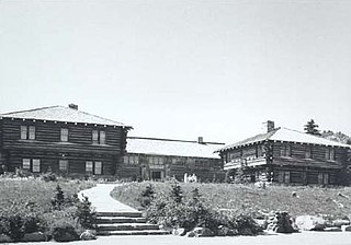
The Yakima Park Stockade Group, also known as North and South Blockhouses and Stockade at Sunrise, is a building complex consisting of four log buildings at the Sunrise Visitors Center area in the northeast part of Mount Rainier National Park. The complex is architecturally significant as a particularly fine example of rustic frontier log architecture. The first of the blockhouses and the stockade were built in 1930, while the second blockhouse followed in 1943. It was declared a National Historic Landmark in 1987. It is in turn part of the Mount Rainier National Historic Landmark District, which encompasses the entire park and which recognizes the park's inventory of Park Service-designed rustic architecture.

U.S. Route 12 is a major east–west U.S. Highway, running from Aberdeen, Washington, to Detroit, Michigan. It spans 430.5 miles (692.8 km) across the state of Washington, making it the second longest highway in the state. It is also the only numbered highway to span the entire state from west to east, starting near the Pacific Ocean, and crossing the Idaho state line near Clarkston. It crosses the Cascade Range over White Pass, south of Mount Rainier National Park. Portions of it are concurrent with Interstate 5 (I-5) and Interstate 82 (I-82), although the majority of the route does not parallel any interstate highway.

The Sunrise Comfort Station (S-310) is a comfort station in Mount Rainier National Park, Washington, USA. Built around 1930, the building was designed by Thomas Chalmers Vint of the National Park Service in association with landscape architect E.A. Davidson. The structure was part of a planned ensemble at what was then called Yakima Park, high on the northern flank of Mount Rainier. Similar structures may be found at the Ohanapecosh, Longmire and White River campgrounds in the park. The low building is framed in peeled logs on a stone foundation, set into a hillside and surrounded by native landscaping.

The Sunrise Historic District, also known as the community of Sunrise, Washington, is located at approximately 6,400 feet (2,000 m) on a ridge overlooking the northeast side of Mount Rainier in Mount Rainier National Park. The district comprises seven individual structures designed in accordance with the principles of the National Park Service Rustic style. The area is inhabited and open to the public only during a brief period in the summer season.

The White River Entrance to Mount Rainier National Park is a complex of buildings built between 1929 and 1931 to accommodate visitors arriving on the Yakima Park Highway, in the northeastern portion of the park. Like most of the structures in Mount Rainier, the buildings are designed in the National Park Service Rustic style, using natural stone and log materials. The historic district includes the 1933 Men's Mess Hall and Dormitory, believed to be the only surviving camp structure built by the Civilian Conservation Corps in the park.

The Chinook Pass Entrance Arch marks the east entrance to Mount Rainier National Park. The rectangular log entry arch is one of several placed at the entrances to the park. It was designed in 1933 by the National Park Service Branch of Plans and Designs, and was built in 1936 by the Civilian Conservation Corps. The arch consists of two stone abutments carrying horizontal logs over the road. The arch functions as a bridge, carrying a horse trail, which is now part of the Pacific Crest Trail.

The White River Bridge was built in 1929 in Mount Rainier National Park as part of the Yakima Park Road project. The new road was planned to open up access to the northeastern portion of the park. The bridge, spanning the White River, was built by contractor John D. Tobin of Portland, Oregon, who had previously built the Narada Falls Bridge and the Christine Falls Bridges, both listed on the National Register of Historic Places. Plans for the bridge were drawn by the National Park Service Branch of Plans and Designs in the National Park Service Rustic style, with construction supervision by NPS landscape architect Ernest A. Davidson. The three-centred arch spans 60 feet (18 m), with a stone-faced concrete structure.
Architects of the National Park Service are the architects and landscape architects who were employed by the National Park Service (NPS) starting in 1918 to design buildings, structures, roads, trails and other features in the United States National Parks. Many of their works are listed on the National Register of Historic Places, and a number have also been designated as National Historic Landmarks.


