
The Yamuna is the second-largest tributary river of the Ganges by discharge and the longest tributary in India. Originating from the Yamunotri Glacier at a height of about 4,500 m (14,800 ft) on the southwestern slopes of Bandarpunch peaks of the Lower Himalaya in Uttarakhand, it travels a total length of 1,376 kilometres (855 mi) and has a drainage system of 366,223 square kilometres (141,399 sq mi), 40.2% of the entire Ganges Basin. It merges with the Ganges at Triveni Sangam, Prayagraj, which is a site of the Kumbh Mela, a Hindu festival held every 12 years.

The Tarim River, known in Sanskrit as the Śītā, is an endorheic river in Xinjiang, China. It is the principal river of the Tarim Basin, a desert region of Central Asia between the Tian Shan and Kunlun Mountains. The river historically terminated at Lop Nur, but today reaches no further than Taitema Lake before drying out.

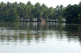
Chaliyar River is the fourth longest river in Kerala at 169 km in length. The Chaliyar is also known as Chulika River, Nilambur River or Beypore River as it nears the sea. Pothukal, Chungathara, Nilambur, Mampad, Edavanna, Kavanoor, Perakamanna, Areekode, Kizhuparamba, Elamaram, Cheekkode, Vazhakkad, Vazhayur, Cheruvadi, Edavannappara, Mavoor, Peruvayal, Feroke and Beypore are some of the towns/villages situated along the banks of Chaliyar. It mainly flows through Malappuram district. Its tributaries flow through both the districts of Malappuram and Kozhikode. The bank of river Chaliyar at Nilambur region is also known for natural Gold fields. Explorations done at the valley of the river Chaliyar in Nilambur has shown reserves of the order of 2.5 million cubic meters of placers with 0.1 gram per cubic meter of gold. It originates at Ilambaleri hills of Nilgiri Mountains in Nilgiris district, which is also near Wayanad-Malappuram district border. It flows mainly through the erstwhile region of Eranad, and finally empties into the Arabian Sea at Beypore port, opposite to Chaliyam harbour.

The Kali Sindh, is a river in Madhya Pradesh and Rajasthan in northern India. It is a tributary of the Chambal River in the Ganges Basin. The main tributaries of the Kali Sindh are the Parwan, Niwaj and Ahu rivers. The Kali Sindh River drains a major portion of the Malwa region, and is the biggest river flowing in the Malwa region of Madhya Pradesh.
Karamana is a river flowing through the city of Thiruvananthapuram in Kerala, India. The river starts near the southern tip of the Western Ghats(Sahyadri Mountains) at Agastyar Koodam. The river flows 66 km westward and merges with the Arabian sea at Panathura near Kovalam. The river gets its name from Karamana, a suburb of Thiruvananthapuram city, through which it flows.
The Gambhir River, which is also known as the Utangan River, is an ephemeral (seasonal) river in India which originates in Rajasthan state and confluences with Yamuna in Uttar Pradesh state. Important tributaries of the Gambhir are Banganga, Sesa, Kher, Churaho and Parbati.

Dausa District is a district of Rajasthan state in India within Jaipur division. The city of Dausa is the district headquarters. It has an area of 3432 km² and a population of 1,634,409 in 2011 census. It is surrounded by Alwar District in the north, Bharatpur district in the northeast, Karauli district in the southeast, Sawai Madhopur district in the south, and Jaipur district in the west. The Sawa and Banganga rivers run through the district. It is situated on the National Highway 21 from Jaipur to Agra. It is 55 km to the east of Jaipur and 103 km from Sawai Madhopur.

The Ćehotina, also known as the Ćeotina, Ćotina or Čehotina, is a 125 kilometres (78 mi) long river in Montenegro and Bosnia and Herzegovina. It is a right bank tributary of the Drina river.

The Piva is a river in Montenegro and Bosnia and Herzegovina. The river runs through Montenegro for the most of its course length, and in its last three kilometres represents the border between the two countries.

The Tamnava is a river in western Serbia. It is a 90 km (56 mi)-long left tributary of the Kolubara River and also gives the name to the surrounding region of Tamnava.

Dihing or Burhi Dihing is a large tributary, about 380 kilometres (240 mi) long, of the Brahmaputra River in Upper Assam in northeastern India. The river originates at 2,375 metres (7,792 ft) above sea level in the Eastern Himalayas in Arunachal Pradesh and flows through Tinsukia (Tinicukeeya) and Dibrugarh Districts in Assam to its confluence with the Brahmaputra at Dihingmukh. Its watershed covers about 6,000 square kilometres (2,300 sq mi). The Dihing has created number of oxbow lakes in the area.

Himachal Pradesh provides water to both the Indus and Ganges basins. The drainage systems of the region are the Chenab, the Ravi, the Beas, the Satluj and the Yamuna. These rivers are perennial and are fed by snow and rainfall. They are protected by an extensive cover of natural vegetation.
The Arvari River, which originates in Aravalli range, is a small river flowing through the Alwar District of Rajasthan, India. It has a total length of 45 km (28 mi) and a total basin area of 492 km2 (190 sq mi). Downstream of the Sainthal Sagar dam on Arvari, the Arvari river meets Sarsa River to become the Sanwan River. The Sanwan meets the Tildah and Banganga rivers to converge with the Gambhir. Gambhir then converges with the Yamuna in Mainpuri district of Uttar Pradesh, Yamuna converges with Ganges at Triveni Sangam in Prayagraj.
The Kiul River is a tributary of Ganges. It originates in Giridih of Jharkhand and flows through Lakhisarai, Sheikhpura and Jamui districts of the Indian state of Bihar and joins Harohar river in the Diara region.
The Mogral River is a west-flowing river in the Kasaragod district in the Indian state of Kerala. It is named after Mogral, a coastal village on its northern banks. The river empties into the Arabian Sea at Mogral Puthur. It has a length of 34 kilometers and a drainage area of 132 square kilometers.
The Morel River originates in the hills near Dharla and Chainpura villages in Bassi Tehsil of Jaipur District, second branch makes by receiving water from the catchment area of foothills of Paplaj Mataji mountains, district Dausa, Rajasthan.

The Sahibi river, also called the Sabi River, is an ephemeral, rain-fed river flowing through Rajasthan, Haryana and Delhi states in India. It originates in the eastern slopes of the Saiwar Protected Forest (PF) hills in Sikar District, enters Jaipur district near the foot of these hills, and after initially flowing southeast and east turns northeastwards near Shahpura and continues further till it exits Rajasthan to enter Haryana and further drains into Yamuna in Delhi, where its channeled course is also called the Najafgarh drain, which also serves as Najafgarh drain bird sanctuary. It flows for 300 km of which 157 km is in Rajasthan 100 km is in Haryana and 40 km in Delhi.
The Krishnavati river, also called Kasaunti, is a rain-fed river originates from Aravalli Range near Dariba copper mines in Rajsamand district of Rajasthan, and flows through Patan in Dausa district and Mothooka in Alwar district and then disappears in Mahendragarh district in Haryana where it use to be a tributary of Sahibi River, which in turn still is a tributary of Yamuna. Several Ochre Coloured Pottery culture sites have been found along the banks of Krishnavati, Sahibi river, Dohan river and Sota River. The drainage pattern for all these rivers is dendritic.
The Dohan river, is a rain-fed river that originates at Mandholi village near Neem Ka Thana in Sikar district of Rajasthan and then disappears in Mahendragarh district in Haryana where it used to be a tributary of Sahibi River, which in turn is a still flowing tributary of Yamuna. Its canalised portion in one of its paleochannel in Haryana is called the "Outfall Drain No 8".

Banganga River, an 240 km long tributary of Gambhir river in India, originates from the hills of Aransar and Bairath in Jaipur region of Rajasthan state and converges with Yamuna near Fatehabad in Agra district of Uttar Pradesh state. Its main tributaries are Gumti Nalla and Suri River on right bank, and Sanwan and Palasan Rivers on left bank. Banganga's tributary Sanwan after converging with Tildah river then converges with Banganga river which in turn then converges with the Gambhir river which in turn converges with the Yamuna in Mainpuri district of Uttar Pradesh. Finally, Yamuna converges with Ganges at Triveni Sangam in Prayagraj.