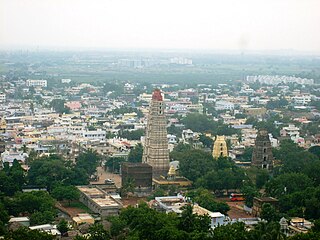
Mangalagiri is one of the two corporations in Guntur District and a major residential and IT hub in Andhra Pradesh Capital Region. The city of Mangalagiri Tadepalli Municipal Corporation is a part of Tenali revenue division. Mangalagiri is important to the overall Guntur's financial and cultural profile by its textile, agricultural and spiritual contributions. The railway station of Mangalagiri is part of Guntur Railway Division. It is situated on National Highway 16 and North of District Headquarter Guntur.

Krishna district is a district in the Coastal Andhra region in Indian state of Andhra Pradesh, with Machilipatnam as its administrative headquarters. It is surrounded on the East by Bay of Bengal, West by Guntur, Bapatla and North by Eluru and NTR districts and South again by Bay of Bengal.
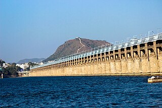
Vijayawada, also known by its colonial name Bezawada, is the second largest city and commercial hub in the Indian state of Andhra Pradesh. The city is part of the Andhra Pradesh Capital Region and is located on the banks of the Krishna River surrounded by the hills of the Eastern Ghats, known as the Indrakeeladri Hills. The city is home to the important Hindu shrine of Kanaka Durga Temple. It geographically lies on the center spot of Andhra Pradesh. The city has been described as the commercial, political, cultural and educational capital of Andhra Pradesh. It is the administrative headquarters of NTR district. The Prakasam Barrage across the Krishna River connects the NTR and Guntur districts.

Machilipatnam, also known as Masulipatnam and Bandar, is a city in Krishna district of the Indian state of Andhra Pradesh. It is a municipal corporation and the administrative headquarters of Krishna district. It is also the mandal headquarters of Machilipatnam mandal in Machilipatnam revenue division of the district. The ancient port town served as the settlement of European traders from the 16th century, and it was a major trading port for the Portuguese, British, Dutch and French in the 17th century.
The Jalaput Dam is a hydroelectric dam built on the Machkund River, a tributary of the Godavari River in India which rises in the Mudugal hills of Alluri Sitharama Raju district and near Ondra Gadda it becomes the boundary between Andhra Pradesh and Odisha. This Dam is the most ignored one in India, and currently it is in dilapidated condition.
Bapatla is a town and district headquarters of Bapatla district in the Indian state of Andhra Pradesh. It is a municipality and the mandal headquarters of Bapatla mandal of Bapatla revenue division. The nearest towns and cities to Bapatla are Chirala, Ponnur, Tenali and Guntur of 17 km, 22 km, 50 km and 53 km respectively.

Anakapalli is a residential neighborhood in the city of Visakhapatnam, also the headquarters of Anakapalli district of Andhra Pradesh. In 2015 Anakapalli municipality was merged with the Greater Visakhapatnam Municipal Corporation. It falls under zone 7 of GVMC. It contains India's second largest jaggery market.

Gunupur is a Municipality and one of the sub-divisional headquarters of Rayagada district in the Indian state of Odisha. It is the second biggest town in Rayagada district.

Ichchapuram is a town in the Srikakulam district of the Indian state of Andhra Pradesh. The town is located nearly 142 km from the district capital, Srikakulam. It is located on the border of Odisha and Andhra Pradesh. Ichchapuram municipality is the largest urban local body in the Srikakulam district. It had a population of 36,493 as of 2011.
Vuyyuru is a town in Krishna district of the Indian state of Andhra Pradesh. It is a Nagar panchayat and the headquarters of Vuyyuru Mandal. It is emerging as neighbourhood of Vijayawada, India situated 30 km away.

The River Nagavali also known as Langulya is one of the main rivers of Southern Odisha and Andhra States in India, between Rushikulya and Godavari basins.

Avanigadda is a town in Krishna district of the Indian state of Andhra Pradesh. It is the mandal headquarters of Avanigadda mandal in Machilipatnam revenue division.

Narasannapeta is a census town in Srikakulam district of the Indian state of Andhra Pradesh. It is the mandal headquarters of Narasannapeta mandal in Srikakulam revenue division. 43 villages are there under the administrative division of Narasannapeta.

Kalingapatnam is a village in Srikakulam district of the Indian state of Andhra Pradesh. It is located in Gara mandal of Srikakulam revenue division. It has one of the major beach sand deposits of the state. In medieval era it was famous for the ancient port city of Kalinga. Kalingapatnam is located at a distance of 26 km from the district headquarters and 17 km from Singupuram.
Mukhalingam, also known as Srimukhalingam or Mukhalinga, is a village panchayat in Jalumuru mandal of Srikakulam district in the Indian state of Andhra Pradesh. Historically known as Kalinganagari, Mukhalingam served as the capital of Eastern Ganga Dynasty from 6th century AD to 12th century AD. Emperor Sri Ananthavarma Chodaganga Devara conquered Utkala in 1122 AD and shifted the capital from Kalinganagari to Caudwara kataka

Andhra Pradesh is a state in India. Andhra Pradesh Tourism Development Corporation (APTDC) is a state government agency which promotes tourism in Andhra Pradesh, describing the state as the Koh-i-Noor of India. Andhra Pradesh has a variety of tourist attractions including beaches, hills, caves, wildlife, forests and temples.
Chilakaluripet is a city in Palnadu district of the Indian state of Andhra Pradesh. It is the Mandal headquarters of Chilakaluripet Mandal in Narasaraopet Revenue Division.
Kantragada is a village in Palasa mandal, Srikakulam district in the state of Andhra Pradesh, India. It is located 1.5 km from the state Orissa. The village was established on Varahalagadda Stream in the mid-19th century during the British colonial period when people migrated from nearby village Goppili. Kantragada was part of the Tharlakota kingdom under Kalingas.
Badagam is a small village in the Rayagada Block and Parlakhemundi municipality in Gajapati district in the Indian state of Odisha. The major languages spoken in this place are Kui and Oriya.

Tourism in India is economically significant and projected to continue a pattern of growth. The World Travel & Tourism Council calculated that tourism generated ₹14.02 lakh crore (US$160 billion) or 9.6% of the nation's GDP in 2016 and supported 40.343 million jobs, 9.3% of its total employment. The sector is predicted to grow at an annual rate of 6.8% to ₹28.49 lakh crore (US$330 billion) by 2027.

