The Hochtaunuskreis is a Kreis (district) in the middle of Hesse, Germany and is part of the Frankfurt/Rhine-Main Metropolitan Region. Neighbouring districts are Lahn-Dill, Wetteraukreis, district-free Frankfurt, Main-Taunus, Rheingau-Taunus, Limburg-Weilburg.
Main-Taunus is a Kreis (district) in the middle of Hessen, Germany and is part of the Frankfurt/Rhine-Main Metropolitan Region as well as the Frankfurt urban area. Neighboring districts are Hochtaunuskreis, district-free Frankfurt, Groß-Gerau, district-free Wiesbaden, Rheingau-Taunus. It is the second most densely populated rural district in Germany.
Rheingau-Taunus is a Kreis (district) in the west of Hesse, Germany. Rheingau-Taunus-Kreis is part of the Darmstadt region; its main administrative seat is Bad Schwalbach. Outposted sections of the local administration are located in Idstein and Rüdesheim am Rhein.
Limburg-Weilburg is a Kreis (district) in the west of Hesse, Germany. Neighboring districts are Lahn-Dill, Hochtaunuskreis, Rheingau-Taunus, Rhein-Lahn, Westerwaldkreis.

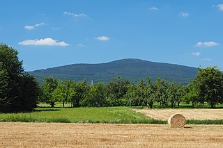
The Großer Feldberg is, at a height of 879.5 metres, the highest elevation of the Taunus mountains, and of the entire Rhenish Massif. It is situated in the Hochtaunuskreis district in Hesse, Germany.

Selters (Taunus) is a municipality with 8,000 inhabitants north of Bad Camberg in Limburg-Weilburg district in Hesse, Germany.

Bad Camberg is, with 14,500 inhabitants, the second largest town in Limburg-Weilburg district in Hesse, Germany, as well as the southernmost town in the Regierungsbezirk of Gießen. It is located in the eastern Taunus in the Goldener Grund some 30 km north of Wiesbaden, 18 km southeast of Limburg an der Lahn, and 44 km northwest of Frankfurt, as well as on the German Timber-Frame Road. Bad Camberg is the central community of the Goldener Grund with good infrastructure, and a lower centre partly with a middle centre's function.
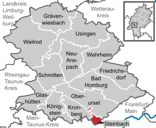
Steinbach is a town in the Hochtaunuskreis that borders Frankfurt am Main to the east. Other neighbouring towns are Oberursel, Kronberg im Taunus and Eschborn. It is in the German state of Hesse.

The Rhine Taunus Nature Park, located in the Rheingau-Taunus-Kreis and Wiesbaden district of Hesse, Germany was founded in 1968. It includes the western part of the Taunus and extends over the Idsteiner Becken to the Rhine. It is characterized by a roughly 60 percent forested low mountain landscape, which falls away steeply toward the Rhine Gorge.
The Altkönig is the third highest mountain of the Taunus range in Hesse, Germany, reaching a height of 798.2 m above sea level (NHN).

The Atzelberg is a mountain of the Taunus near Eppenhain, constituent community of Kelkheim, Hesse, Germany. Its silhouette is remarkable for a Typenturm radio tower. It is part of the natural region High Taunus although being part of the Main-Taunus-Kreis as well.

The Hallgarter Zange is a hill in the Taunus mountains of Hesse, Germany.
Koberg is a hill of Hesse, Germany.

Pferdskopf is a 662.6 meter high mountain of Hesse, Germany.

Rossert is a mountain of the Taunus, part of the Anterior Taunus, in Hesse, Germany. The mountain consists of a few hilltops, two of them giving the name the Naturschutzgebiet Rossert - Hainkopf - Dachsbau. Between them lies Eppenhain, a constituent community of Kelkheim. The name Rossert originates from an Old High German word for cobblestones.

Stückelberg is a mountain in the Taunus range. It is located in the Taunus Nature Park in Hesse, Germany.
Hohe Warte is a mountain of Landkreis Waldeck-Frankenberg, Hesse, Germany.

The Erbacher Kopf is a hill in the Taunus range in Hesse, Germany.
