Related Research Articles

Oscar II Land is the land area between Isfjorden and Kongsfjorden on Spitsbergen, Svalbard. The 30 km (19 mi) long glacier Sveabreen divides Oscar II Land from James I Land.
James I Land is a land area on the northwestern part of Spitsbergen, Svalbard. It is named after King James I of England and Scotland. The 30 kilometer long glacier Sveabreen divides James I Land from Oscar II Land.
Barentsjøkulen is a glacier on Barentsøya, Svalbard. The glacier covers an area of about 571 km2 (220 sq mi). It is named after the Barents Island, which again is named after Dutch explorer Willem Barentsz. Barents Island is on the Barents Sea.

Hornbreen lies between Torell Land and Sørkapp Land on Spitsbergen, Svalbard. The glacier debouches into Hornsund. Former names of the glacier include Ramme Gletscher and Horn Glacier. Hornbreen has a length of about 15 km, and width of 8 km.
Hellefonna is a glaciated area in Sabine Land at Spitsbergen, Svalbard. It is located between Kjellströmdalen and Sassendalen, and comprises several smaller glaciers, including Jinnbreen, Innerbreen, Marmorbreen, Skruisbreen and Sveigbreen. The area is named after topographer Sigurd Gunnarson Helle.
St. Jonsfjorden is a fjord in Oscar II Land at Spitsbergen, Svalbard. It has a length of 21 kilometer, and opens westwards into the strait of Forlandsundet. Several glaciers debouche into the fjord, including Gaffelbreen and Konowbreen from the north, a merge of Osbornebreen, Devikbreen, Vintervegen, Paulbreen and Bukkebreen at the bottom, and Vegardbreen, Charlesbreen and Bullbreen from the south.
Osbornebreen is a glacier in Oscar II Land at Spitsbergen, Svalbard, Norway. It has a length of 21 kilometers, merges with the glaciers Devikbreen, Klampebreen and Vintervegen, and debouches into St. Jonsfjorden. The mountain ridge Goldschmidtfjella forms a six kilometer long nunatak in the glacier.
Vintervegen is a glacier in Oscar II Land at Spitsbergen, Svalbard. It has a length of about 7.5 kilometers (4.7 mi). The glacier borders to the mountain of Klampen, merges with Osbornebreen and other glaciers, and the merged glacier stream debouches into the head of St. Jonsfjorden.
Agardhdalen is a valley between Sabine Land and Heer Land at Spitsbergen, Svalbard. It forms a continuation of the bay Agardhbukta, at the western side of Storfjorden. The valley is named after botanist Jacob Georg Agardh. The river Agardhelva flows from Sveigbreen and Elfenbeinbreen, through Agardhdalen, with outlet into Agardhbukta.
Agardhelva is a river forming the border between Sabine Land and Heer Land at Spitsbergen, Svalbard. It flows through the valley of Agardhdalen, from the glaciers Elfenbeinbreen and Sveigbreen, ending into the bay Agardhbukta at the western side of Storfjorden. The river is named after botanist Jacob Georg Agardh.
Elfenbeinbreen is a glacier stream in Sabine Land at Spitsbergen, Svalbard. It has a length of about twelve kilometers, and extends from the southern part of the ice cap Nordmannsfonna. The glacier is one of the two main sources to the river Agardhelva, which flows through Agardhdalen towards Agardhbukta.
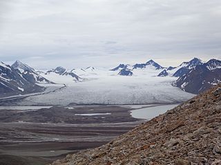
Sefströmbreen is a glacier in James I Land at Spitsbergen, Svalbard. It is debouching into Ekmanfjorden at the northern side of Isfjorden. The glacier is named after Nils Gabriel Sefström. During a surge in 1896 the glacier deposited large moraine ridges in the inner part of the fjord, and these can be seen at the islands of Coraholmen and Flintholmen. Sefströmbreen is included in the Nordre Isfjorden National Park.
Coraholmen is an island in Ekmanfjorden in James I Land at Spitsbergen, Svalbard, at the northern side of Isfjorden. It has a length of 3.3 kilometers, and a width of 1.8 kilometers. The island is named after the fossil species Productus cora, which is common on the island. Part of the island is dominated by moraine ridges deposited by the glacier Sefströmbreen during a surge in 1896. Coraholmen is included in the Nordre Isfjorden National Park.
Kropotkinfjellet is a mountain in Sabine Land at Spitsbergen, Svalbard. It has an extension of about seven kilometers, with two glaciated peaks, and is located between the glaciers of Sveigbreen and Skruisbreen. The mountain is named after Russian prince and scientist Peter Kropotkin.
Freemanbreen is a glacier on Barentsøya, Svalbard. It is an offshoot of Barentsjøkulen, reaching down to the sea in the southern direction, into Freeman Strait. The glacier is named after British Alderman Ralph Freeman. The mountain of Buklerimen separates Freemanbreen from the glacier of Hübnerbreen.
Uvêrsbreen is a glacier in Oscar II Land at Spitsbergen, Svalbard. It has a length of about 25 kilometers. The glacier debouches into Engelskbukta, after merging with Comfortlessbreen.
Comfortlessbreen is a glacier in Oscar II Land at Spitsbergen, Svalbard. It has a length of about fourteen kilometers, and a maximum width of three kilometers. The glacier debouches into Engelskbukta, after a merge with Uvêrsbreen. Comfortlessbreen is separated from Uvêrsbreen by the mountain range of Trondheimfjella.
Aavatsmarkbreen is a glacier in Oscar II Land at Spitsbergen, Svalbard. It is named after politician and military officer Ivar Aavatsmark. The glacier debouches into Forlandsundet, in the bay of Hornbækbukta. At the southern side of the glacier, between Aavatsmarkbreen and Kaffiøyra, is the mountain range of Prins Heinrichfjella.
Petuniabukta is a bay in Dickson Land at Spitsbergen, Svalbard. It constitutes the northern branch of Billefjorden. The bay is named after the Scottish vessel SS Petunia. Northwest of the bay is the valley of Hørbyedalen and the glacier of Hørbyebreen.
References
- ↑ "Sveigbreen (Svalbard)". Norwegian Polar Institute . Retrieved 8 July 2013.
- ↑ "Agardhelva (Svalbard)". Norwegian Polar Institute . Retrieved 8 July 2013.
78°06′36″N17°42′00″E / 78.11000°N 17.70000°E
| | This article about a glacier in Spitsbergen is a stub. You can help Wikipedia by expanding it. |