Sunnhordland is a traditional district in the Vestlandet region of Norway. The district consists of the southern coastal regions of Hordaland county. In includes the areas that surround the mouth of the Hardangerfjorden and the surrounding islands. The municipalities of Sveio, Etne, Stord, Bømlo, Fitjar, Kvinnherad, and Tysnes make up the district of Sunnhordaland. The regional centre of this district is the town of Leirvik in Stord.

Rosendal is the administrative centre of the municipality of Kvinnherad in Hordaland county, Norway. The village is located on the southern shore of the Hardangerfjorden, about 4 kilometres (2.5 mi) north of the village of Dimmelsvik and about 10 kilometres (6.2 mi) straight west of the vast Folgefonna glacier which sits inside the nearby Folgefonna National Park. The village is especially known for the Barony Rosendal, a historic estate located in the village. Kvinnherad Church is also located in this village.

Norheimsund is the administrative centre of the municipality of Kvam in Hordaland county, Norway. The village is located on the northern side of the Hardangerfjord, about 80 kilometres (50 mi) from the city of Bergen. The village of Øystese lies about 4 kilometres (2.5 mi) to the northeast and the village of Vikøy lies about 3 kilometres (1.9 mi) southeast of Norheimsund. The village of Steine is a suburb, immediately to the west of Norheimsund. The 2.5-square-kilometre (620-acre) village has a population (2012) of 2,224; giving the village a population density of 890 inhabitants per square kilometre (2,300/sq mi), the largest settlement in the whole municipality.

Røldal is a village in the municipality of Odda in Hordaland county, Norway. The village lies in the Røldal valley along the Storelva river on the north end of the lake Røldalsvatnet. Røldal is located about 35 kilometres (22 mi) southeast of the town of Odda. Røldal was formerly part of the independent municipality of Røldal from 1838 until 1964 when it became a part of Odda municipality. The 13th-century Røldal Stave Church is located here.
Valestrand is a former municipality in Hordaland county, Norway. The 59-square-kilometre (23 sq mi) municipality was located on a peninsula on the southern shore of the Bømlafjorden inside the present-day municipality of Sveio. The administrative centre of Valestrand was the village of Valevåg. The two churches in Valestrand were Valen Chapel and Valestrand Church.

Etnesjøen or Etne is the administrative centre of Etne municipality in Hordaland county, Norway. The village is located at the inner end of the Etnefjorden, along the European route E134 highway, about 8 kilometres (5.0 mi) south of the village of Skånevik and about 10 kilometres (6.2 mi) northeast of the village of Ølensjøen.
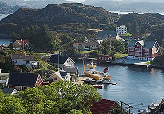
Langevåg is a village in Bømlo municipality in Hordaland county, Norway. It is located on the southern tip of the island of Bømlo, along the Bømlafjorden. It lies in the far southern part of the municipality, about 12 kilometres (7.5 mi) south of the village of Lykling. The 1.15-square-kilometre (280-acre) village has a population (2013) of 796, giving the village a population density of 692 inhabitants per square kilometre (1,790/sq mi). This makes it the fourth largest village in the municipality.

Osøyro is the administrative centre of Os municipality in Hordaland county, Norway. The village lies on the southwestern part of the Bergen Peninsula, along the western shore of the Fusafjorden, about 25 kilometres (16 mi) south of the city centre of Bergen. The European route E39 highway runs through the village on its way to Bergen. There is a car ferry from the east side of Osøyro to the village of Fusa, across the Fusafjorden. Os Church is located in the village.
Auklandshamn or Økland is a village in Sveio municipality in Hordaland county, Norway. The village is located in the northern part of the traditional district of Haugaland, along the southern shore of the Bømlafjorden. Historically, the area was part of the municipality of Finnås, but it was transferred to the municipality of Valestrand in 1870. In 1964, it was transferred to the municipality of Sveio.
Eikelandsosen is the administrative center of the municipality of Fusa in Hordaland county, Norway. It is located at the end of the Eikelandsfjorden, a small arm off the main Fusafjorden. The village sits to the southeast of the village of Holmefjord, west of the village of Holdhus, and northeast of the village of Fusa. The 0.7-square-kilometre (170-acre) village has a population (2013) of 477, giving the village a population density of 681 inhabitants per square kilometre (1,760/sq mi).
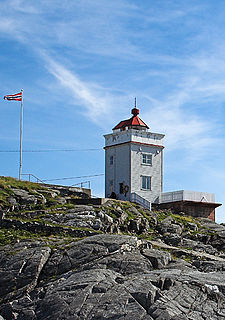
Ryvarden Lighthouse is a coastal lighthouse on the western coast of the municipality of Sveio in Hordaland county, Norway. The lighthouse was established in 1849 to mark the southern shore of the entrance to the Bømlafjorden from the sea. It is located about 8 kilometres (5.0 mi) southwest of the municipal centre of Sveio. In 1984, the lighthouse was automated and it no longer needed a live-in lighthouse keeper on the site. In 2005, the municipality bought the building and the buildings are now used as a regional cultural centre/museum.
Uskedal or Uskedalen is a village in Kvinnherad municipality in Hordaland county, Norway. The village is located in a small valley along the southern shore of the Hardangerfjorden, about 7 kilometres (4.3 mi) southwest of the village of Dimmelsvik and about 4 kilometres (2.5 mi) east of the village of Herøysund.

Hatlestrand is a village in Kvinnherad municipality in Hordaland county, Norway. The village is located along the Hardangerfjorden, northeast of the villages of Husa and Ølve. The village has a ferry port called Gjermundshamn, which has regular ferry connections to the island of Varaldsøy and to Årsnes on the opposite side of the fjord. Hatlestrand Church is located in the village.

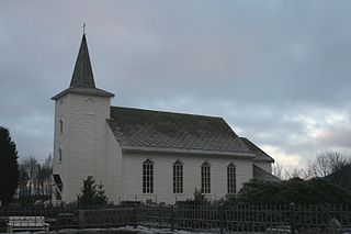
Vikebygd is a former municipality in Hordaland county, Norway. The municipality was located along the eastern and western shores of the Ålfjorden, a small branch off the main Hardangerfjorden. The 102-square-kilometre (39 sq mi) municipality is located in the present-day municipalities of Sveio and in Vindafjord. The administrative centre of the municipality was the village of Vikebygd, where Vikebygd Church is located.
Haga is a village in Samnanger municipality in Hordaland county, Norway. The village is located the northeastern end of the Samnangerfjorden. It is located east of the village of Årland, across the fjord. The municipal centre of Tysse lies immediately south of Haga, and it is considered part of the "urban area" of Haga. The 0.89-square-kilometre (220-acre) village area of Haga is the largest in the municipality and it has a population (2013) of 1083, giving it a population density of 1,217 inhabitants per square kilometre (3,150/sq mi). Haga Church was built in the centre of the village in 1995.
Valevåg is a village in Sveio municipality in Hordaland county, Norway. The village is located on the northern end of the Sveio peninsula, along the southern shore of the Hardangerfjorden. Historically, Valevåg was the administrative centre of the old municipality of Valestrand until it was merged into Sveio in 1964. Valen Chapel is in the village of Valevåg, and just outside the village to the south is the much larger Valestrand Church.

Sæbøvik is a village in Kvinnherad municipality in Hordaland county, Norway. The village is located on the narrow, western part of the island of Halsnøya, about 6 kilometres (3.7 mi) west of the village of Høylandsbygd and immediately east of the village of Eidsvik. The village is located at the southern end of the Halsnøy Tunnel.

Skjold is a former municipality in Rogaland county, Norway. The 172-square-kilometre (66 sq mi) municipality encompassed all the area surrounding the Grindafjorden and Skjoldafjorden. The area is located in the present-day municipalities of Vindafjord and Tysvær. The administrative centre of the municipality was the village of Skjold where the Skjold Church is located.
Vestavind is a local Norwegian newspaper published in Sveio in Hordaland county.


